Hayfield to Edale Circular Walk
View Photos
Hayfield to Edale Circular Walk
Difficulty Rating:
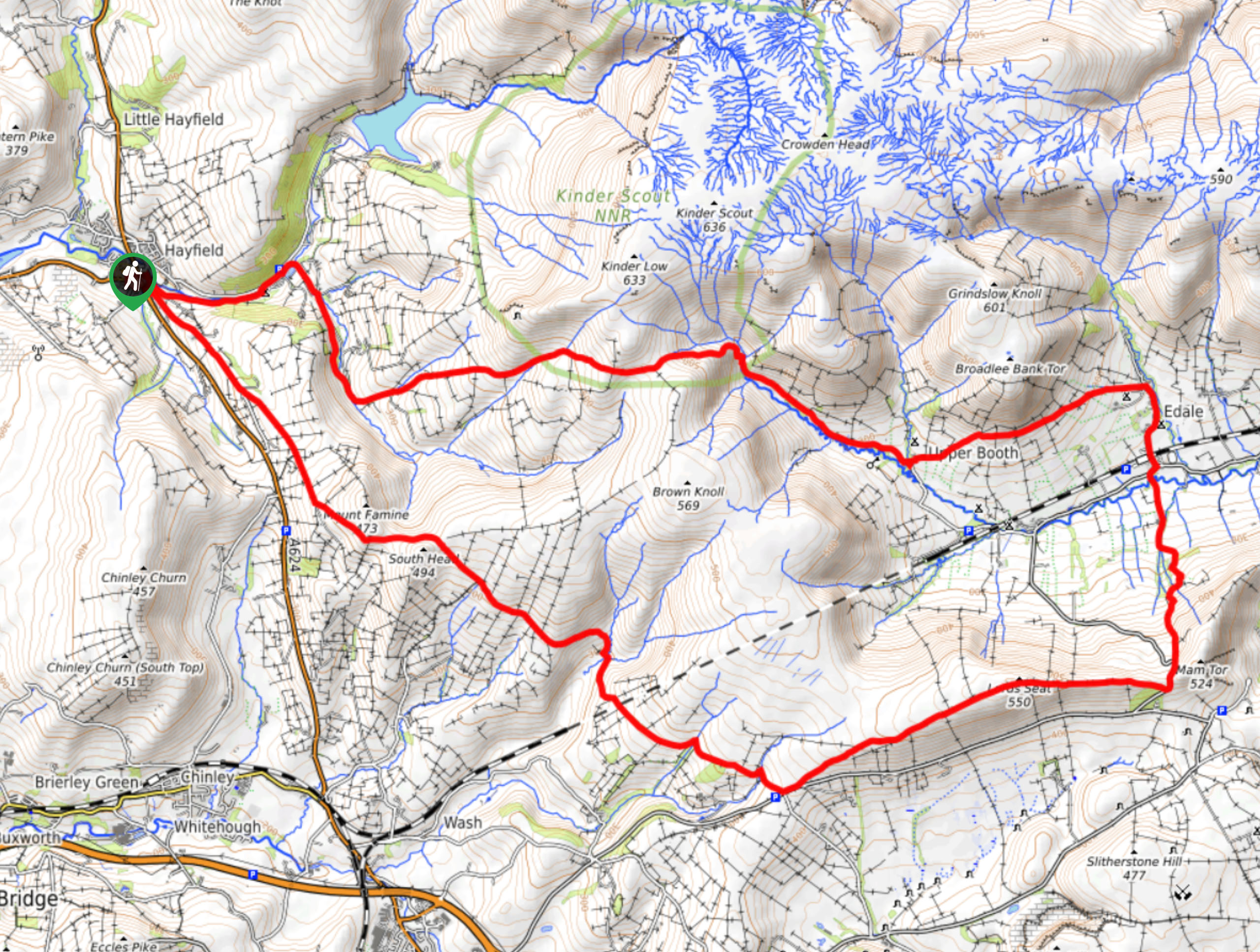
The Hayfield to Edale Circular is a 15.8mi long-distance walking route that will take you from the charming village of Hayfield to experience amazing views that sweep across the Edale Valley. While out on the trail you will traverse some rugged moorland terrain and rocky ridgelines before climbing uphill along the winding Banks of the River Noe on the return portion of the walk. The stunning views over the dramatic Peak District terrain and the longer overall distance make this walk perfect for seasoned walkers and those looking to test themselves on a longer route.
Getting there
To reach the car park for the Hayfield to Edale Circular from Glossop, drive south on Victoria Street/A624 for 4.8mi and turn right onto New Mills Road. After 225ft, turn right onto Station Road and follow it a further 225ft to find the car park on the left.

About
| When to do | March-October |
| Backcountry Campsites | Fieldhead Campsite, Cooper’s Camp, Upper Booth |
| Pets allowed | Yes - On Leash |
| Family friendly | No |
| Route Signage | Average |
| Crowd Levels | Moderate |
| Route Type | Circuit |
Hayfield to Edale Circular Walk
Elevation Graph
Weather
Hayfield to Edale Circular Trail Description
Walking the Hayfield to Edale Circular is a lengthy journey across the picturesque Derbyshire countryside that will expose you to some of the best sights that the Peak District has to offer. The trail sets out from the village of Hayfield in a southeastern direction, traversing the hilly countryside and summiting South Head before turning more to the east to cross the moor on the approach of The Great Ridge.
After crossing the scenic plateau known as the Lord’s Seat, continue making your way east to stop just short of Mam Tor. Instead of climbing up the ridge, follow the path north to descend the hillside and cross the Edale Valley below. After passing through the village and reaching a junction at The Old Nags Head pub, head left along the Pennine Way to climb uphill along the flowing waters of the River Noe and enter Kinder Scout National Nature Reserve. After traversing the rugged and hilly terrain of the moor, continue west to descend the hillside and return to the charming village where you began.
Other amazing walks in Peak District National Park
Check out our guides to Kinder Scout, Mam Tor, Stanage Edge, Dovedale, and Padley Gorge. Or see all of our Peak District walks on 10Adventures.
Similar hikes to the Hayfield to Edale Circular Walk hike

Valehouse Reservoir Circular
The Valehouse Reservoir Circular is a 3.1mi lollipop trail near Glossop that travels around the edge of the…

Three Edges Walk
The Three Edges Walk is a challenging circuit in Derbyshire that will take you along three escarpments that offer some…

Edale Rocky Ridges Walk
The Edale Rocky Ridges Walk is just that - an adventurous walk along a rugged ridgeline. While out on the…
Comments