Agden & Dale Dike Reservoirs Circular Walk
View Photos
Agden & Dale Dike Reservoirs Circular Walk
Difficulty Rating:
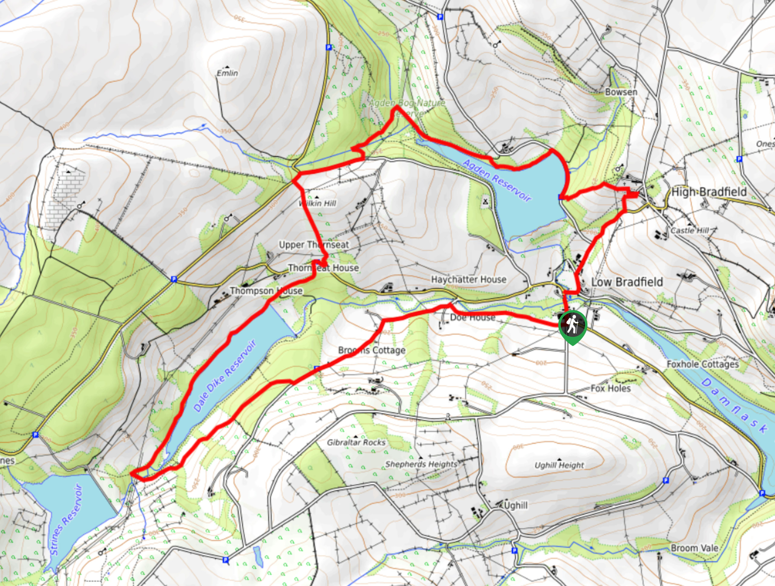
The Agden & Dale Dike Reservoirs Circular Walk is a 6.6mi circuit that will take you from the village of Low Bradfield to traverse the terrain along the shores of these two scenic bodies of water. While out on the trail, you will experience views of some of the beautiful landscapes that the Peak District is known for and enjoy the relaxing atmosphere along the water’s edge. With scenic views over the water and the opportunity to end your journey at The Plough for some post-walk drinks, this is an excellent weekend adventure for casual and experienced walkers alike.
Getting there
To reach the trailhead from Loxley, head west on Loxley Road for 2.4mi and make a slight left on Trouble Wood Lane. After 0.2mi, continue onto Lamb Hill and follow it for 0.7mi. Turn left onto Smithy Bridge Road and after 320ft, turn left to arrive at the trailhead.

About
| When to do | March-November |
| Backcountry Campsites | Cotton Star Camping |
| Pets allowed | Yes - On Leash |
| Family friendly | Older Children only |
| Route Signage | Average |
| Crowd Levels | Moderate |
| Route Type | Circuit |
Agden & Dale Dike Reservoirs Circular Walk
Elevation Graph
Weather
Agden & Dale Dike Reservoirs Circular Walk Description
While the terrain isn’t overly challenging, the Agden & Dale Dike Reservoirs Circular Walk does feature several sections of trail that can become fairly wet and boggy, particularly after a good rainfall. The paths are well-maintained and signposted, but you will need some decent walking footwear in order to traverse the terrain. For those looking to enjoy some post-walk refreshments, try heading to The Plough or The Schoolrooms in the village.
Setting out from the trailhead in the heart of Low Bradfield, make your way north along the road and head right to skirt around the edge of the cricket pitch and cross over Kirk Bridge. Continue to the northeast into the village of High Bradfield, where you will make your way around the Church of St. Nicholas and turn to the west to eventually meet up with the Agden Reservoir. Take some time to relax and enjoy the views across the water as you walk along the northern edge of the reservoir towards the Agden Bog.
After passing through the boggy terrain and crossing over the Hobson Moss and Emlin dikes, continue to the southwest to reach the edge of the Dale Dike Reservoir. Enjoy the views across the calm water and surrounding farmland as you walk along the partially forested edge of the reservoir. After making your way through Andrew Wood, follow the trail as it passes through the farmland terrain and eventually arrives back in the village. From here, walkers can either pop into the pub for a couple of pints or head back to their vehicle for the journey home.
Other amazing walks in Peak District National Park
Check out our guides to Kinder Scout, Mam Tor, Stanage Edge, Dovedale, and Padley Gorge. Or see all of our Peak District walks on 10Adventures.
Similar hikes to the Agden & Dale Dike Reservoirs Circular Walk hike

Valehouse Reservoir Circular
The Valehouse Reservoir Circular is a 3.1mi lollipop trail near Glossop that travels around the edge of the…

Three Edges Walk
The Three Edges Walk is a challenging circuit in Derbyshire that will take you along three escarpments that offer some…

Edale Rocky Ridges Walk
The Edale Rocky Ridges Walk is just that - an adventurous walk along a rugged ridgeline. While out on the…
Comments