
West to East Woodburn Circular Walk
View Photos
West to East Woodburn Circular Walk
Difficulty Rating:
The West to East Woodburn Circular Walk is an easy-going trail in Northumberland that features laid back country terrain and a riverside setting. While out walking the trail, you will explore the open fields between the villages of West Woodburn and East Woodburn, while also taking in the scenery along the winding banks of the River Rede. This is an excellent route that the entire family will enjoy.
Getting there
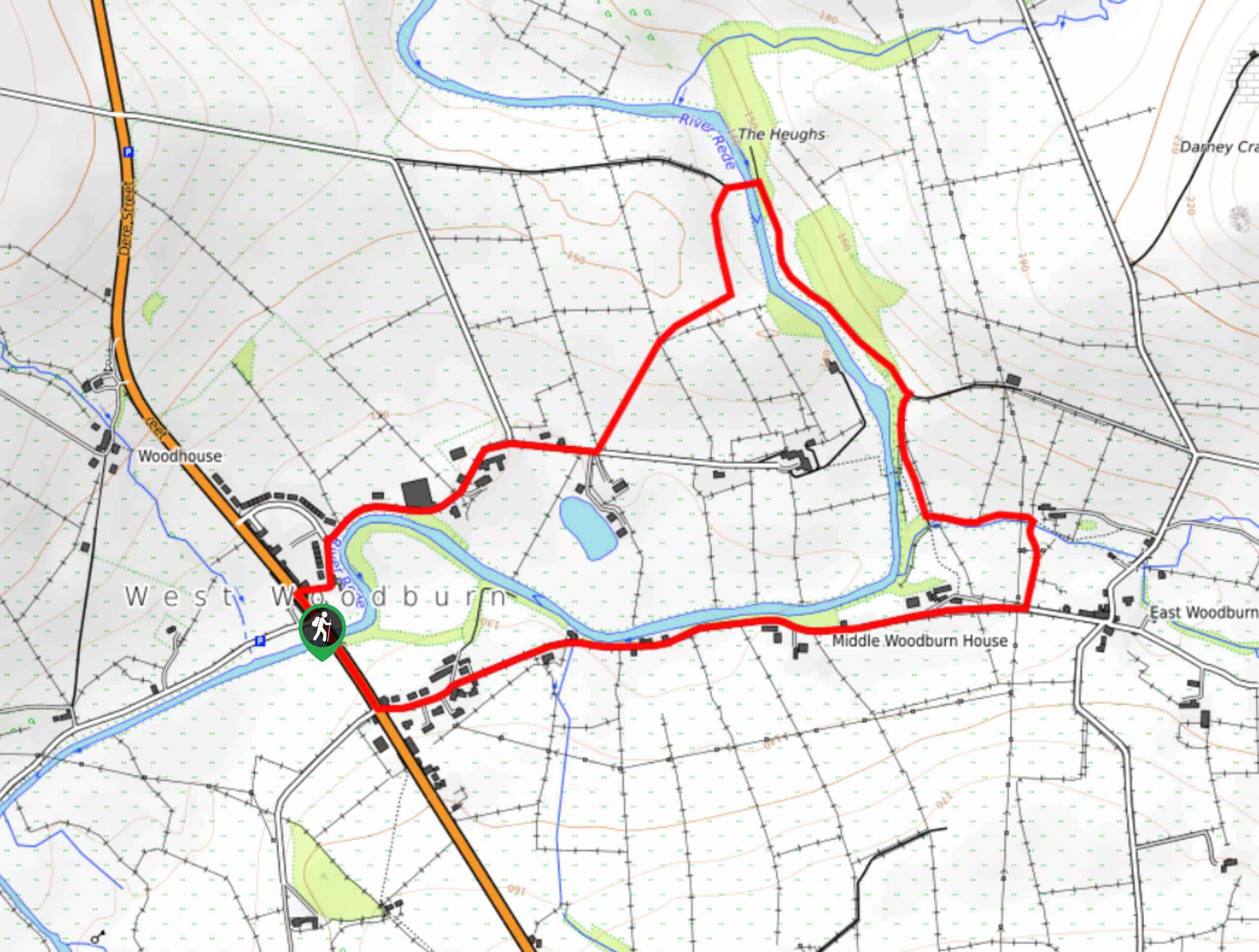
The trailhead for the West to East Woodburn Circular Walk can be found in West Woodburn next to the Bay Horse Inn.

About
| Backcountry Campground | No |
| When to do | Year-Round |
| Pets allowed | Yes - On Leash |
| Family friendly | Yes |
| Route Signage | Average |
| Crowd Levels | Moderate |
| Route Type | Circuit |
West to East Woodburn Circular Walk
Elevation Graph
Weather
West to East Woodburn Circular Walk Description
Featuring a peaceful riverside setting and the picturesque farmlands of Northumberland, the West to East Woodburn Circular Walk is a great route if you are looking to get outside and appreciate the natural beauty of the countryside.
Setting out from the trailhead in West Woodburn, you will initially head south along the A68, before breaking off to the east to traverse a quiet road that cuts across the surrounding farm field. Here, you will walk alongside the River Rede, eventually arriving in the village of East Woodburn.
Turning to the north here, you will make your way along the forested riverbank with a small hill on your right, eventually turning right in order to cross over the East Woodburn Bridge. From here, you will head to the southwest across the countryside, before arriving back in the village where you started the walk.
Similar hikes to the West to East Woodburn Circular Walk hike

Hadrian’s Wall: Steel Rigg to Lanercost
Walking Hadrian’s Wall: Steel Rigg to lanercost is a fantastic - albeit lengthy - adventure that will lead you across…

Hadrian’s Wall: Wallsend to Heddon on the Wall
Hadrian’s Wall: Wallsend to Heddon on the Wall is the first section of the long distance Hadrian’s Wall Path walking…

Scotch Gill Woods Walk
The Scotch Gill Woods Walk is a short and easy-going adventure in Morpeth, Northumberland that will take you through a…
Comments