
Plessey Woods Walk
View Photos
Plessey Woods Walk
Difficulty Rating:
The Plessey Woods Walk is a fantastic family-friendly adventure in Northumberland that will take you through a charming forest setting. While out walking the trail, you will explore the forests within the Plessey Woods Country Park, before following along the winding banks of the River Blythe. This is an excellent route that will allow you to relax and reconnect with the natural world without straying too far from the city.
Getting there
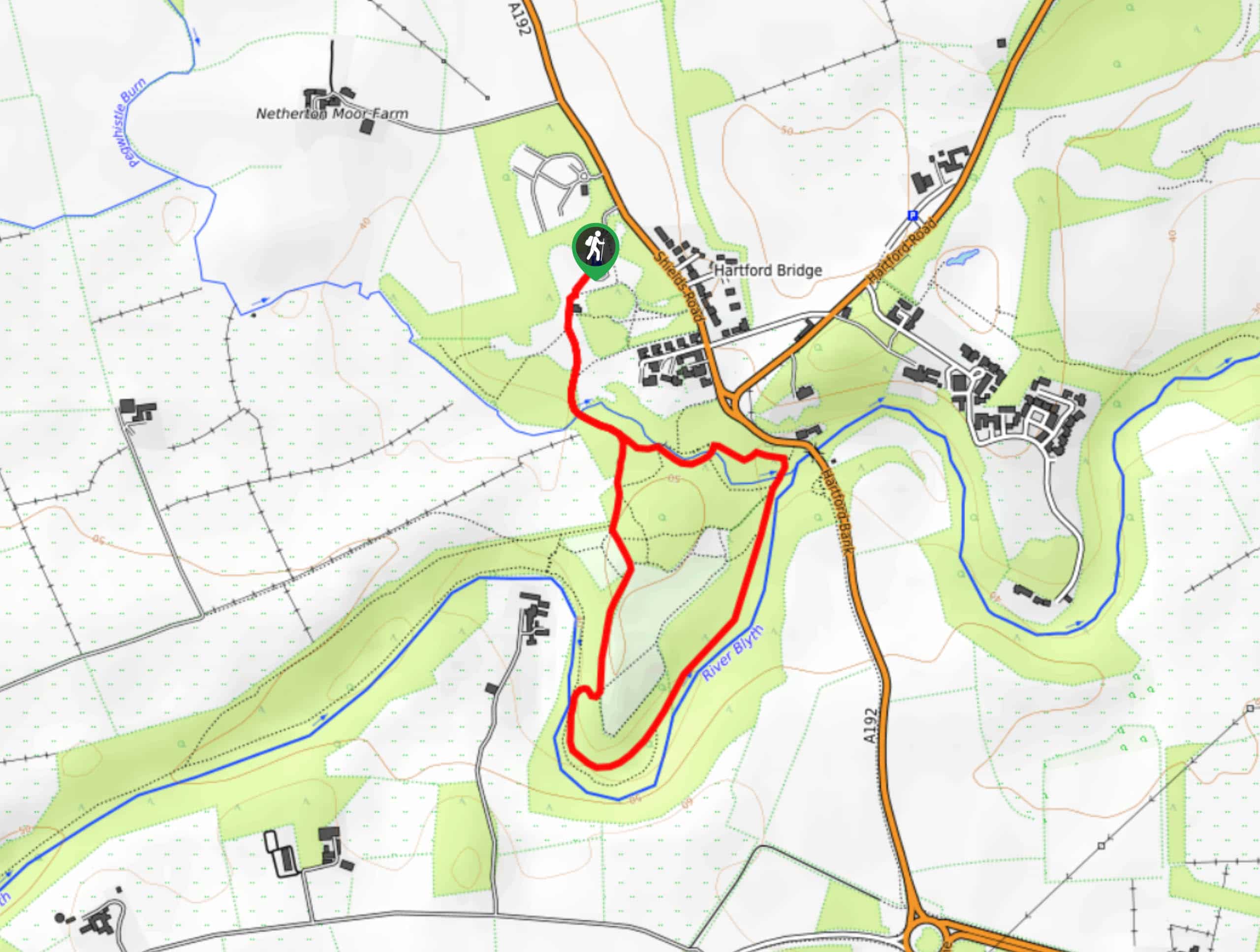
The trailhead for the Plessey Woods Walk can be found at the Plessey Woods Country Car Park off A192.

About
| Backcountry Campground | No |
| When to do | Year-Round |
| Pets allowed | Yes - On Leash |
| Family friendly | Yes |
| Route Signage | Average |
| Crowd Levels | High |
| Route Type | Lollipop |
Plessey Woods Walk
Elevation Graph
Weather
Plessey Woods Walk Description
Although the Plessey Woods Walk is a short and easy-going adventure, the forested paths can often become quite wet and muddy, particularly during the winter/spring seasons. Be sure to wear waterproof walking shoes if you are planning to undertake this walk during these periods. Additionally, this walk can become quite busy, so you will definitely want to arrive early to secure parking.
Even though this route sees a fair amount of foot traffic, the serene stretches of forest and charming riverside settings are still removed enough that you will feel as though you are truly connecting with nature. The paths here are easy to navigate and there are plenty of options for explorations, making this an ideal place to take the family or dogs for a fun outdoor excursion.
Setting out from the trailhead, you will pick up the trail in the southeast corner of the car park and follow it south, passing by the visitor centre, toilets, and children’s play area. From here, you will keep straight along the trail and follow it into the woods, where you will quickly cross over Pegwhistle Burn.
Here, the trail will bend to the southeast and bring you to a fork, at which point you will take the path on the right. Keeping to the right, you will make your way south through the peaceful forested expanse of Half Farm Wood to eventually pass by The Paddock and The Meadow greenspaces.
Continuing along the trail as it runs parallel to the River Blythe, you will loop around to the northeast and continue through the tranquil forest, traversing Valley Wood before arriving at the point where Pegwhistle Burn joins the River Blythe. After crossing over the stream, you will keep left along the trail through Quarry Wood, once again crossing over Pegwhistle Burn to meet back up with your original path.
At this point, you can either take to your own and explore the forest at your own pace, or follow your initial trail back past the visitor centre and towards the car park, having completed your adventure along the Plessey Woods Walk.
Frequently Asked Questions
Do you have to pay for parking at Plessey Woods?
While the first hour of parking at Plessey Woods is free, staying for up to two hours will cost £1.60 and any time over that will be £3.
Are dogs allowed at Plessey Woods?
Yes, dogs are permitted on the trails in the Plessey Woods Country Park, although they should be kept under control at all times.
Insider Hints
Wear comfortable walking shoes that are preferably waterproof, as the trail can become quite muddy.
Be sure to keep your dog on a lead.
Arrive early to secure parking, as this is a busy route.
Toilet facilities can be found at the visitor centre.
Similar hikes to the Plessey Woods Walk hike

Hadrian’s Wall: Steel Rigg to Lanercost
Walking Hadrian’s Wall: Steel Rigg to lanercost is a fantastic - albeit lengthy - adventure that will lead you across…

Hadrian’s Wall: Wallsend to Heddon on the Wall
Hadrian’s Wall: Wallsend to Heddon on the Wall is the first section of the long distance Hadrian’s Wall Path walking…

Scotch Gill Woods Walk
The Scotch Gill Woods Walk is a short and easy-going adventure in Morpeth, Northumberland that will take you through a…
Comments