
Eltringham Bridleway Walk
View Photos
Eltringham Bridleway Walk
Difficulty Rating:
The Eltringham Bridleway Walk is a wonderful woodland adventure in Prudhoe, Northumberland that will take you along the banks of the River Tyne. While out walking the trail, you will traverse a series of pleasant forest pathways, making several small climbs alongside the river before looping around through the park. Walkers should be sure to wear proper footwear, as sections of the trail can become quite wet and muddy after periods of heavy rainfall.
Getting there
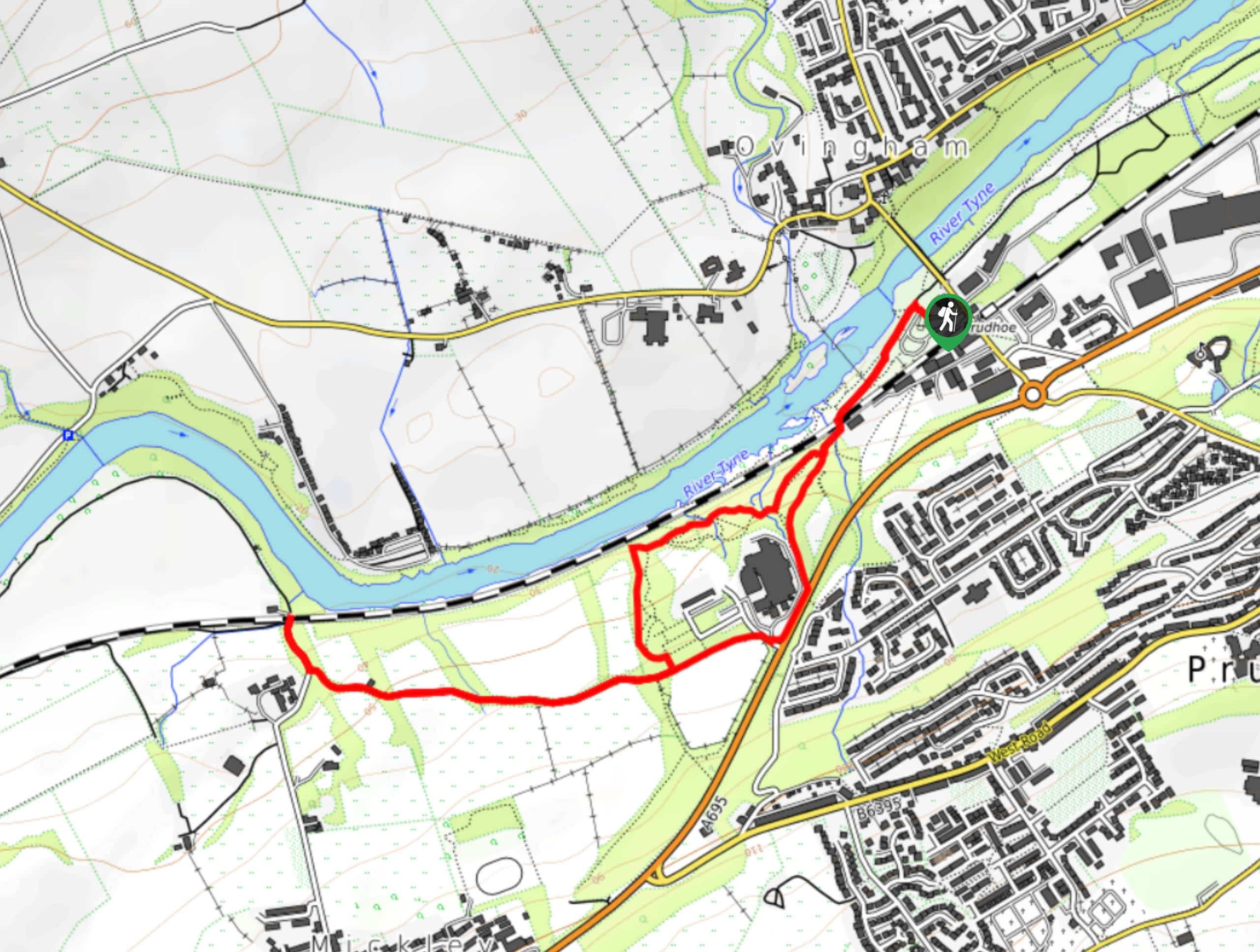
The trailhead for the Eltringham Bridleway Walk can be found at the car park in the Prudhoe Riverside Park.

About
| Backcountry Campground | No |
| When to do | Year-Round |
| Pets allowed | Yes - On Leash |
| Family friendly | Yes |
| Route Signage | Average |
| Crowd Levels | Moderate |
| Route Type | Lollipop |
Eltringham Bridleway Walk
Elevation Graph
Weather
Eltringham Bridleway Walk Description
Featuring a relaxing woodland atmosphere right in the heart of Prudhoe, the Eltringham Bridleway Walk is a perfect route for those times when you need to get outside and reconnect with nature, without actually having to leave the city.
Setting out from the trailhead, you will make your way to the southwest through the lovely landscape of Prudhoe Riverside Park, before crossing over a railway line. Here, you will enter into the dense cover of Eltringham Wood and keep right along the banks of the River Tyne, before turning to the south to skirt around a few buildings.
Continuing along the trail leading west, you will follow the treeline and enjoy views across the beautiful fields surrounding you, eventually arriving at the end point of the route near to where Station Bank Road meets the railway line. At this point, you will turn back along the trail and follow it east, skirting around the right side of the buildings to re-enter Eltringham Wood. Continuing to the northeast, you will once again cross over the railway line and pass through Prudhoe Riverside Park on the return to the car park.
Similar hikes to the Eltringham Bridleway Walk hike

Hadrian’s Wall: Steel Rigg to Lanercost
Walking Hadrian’s Wall: Steel Rigg to lanercost is a fantastic - albeit lengthy - adventure that will lead you across…

Hadrian’s Wall: Wallsend to Heddon on the Wall
Hadrian’s Wall: Wallsend to Heddon on the Wall is the first section of the long distance Hadrian’s Wall Path walking…

Scotch Gill Woods Walk
The Scotch Gill Woods Walk is a short and easy-going adventure in Morpeth, Northumberland that will take you through a…
Comments