
Devil’s Water Circular Walk
View Photos
Devil’s Water Circular Walk
Difficulty Rating:
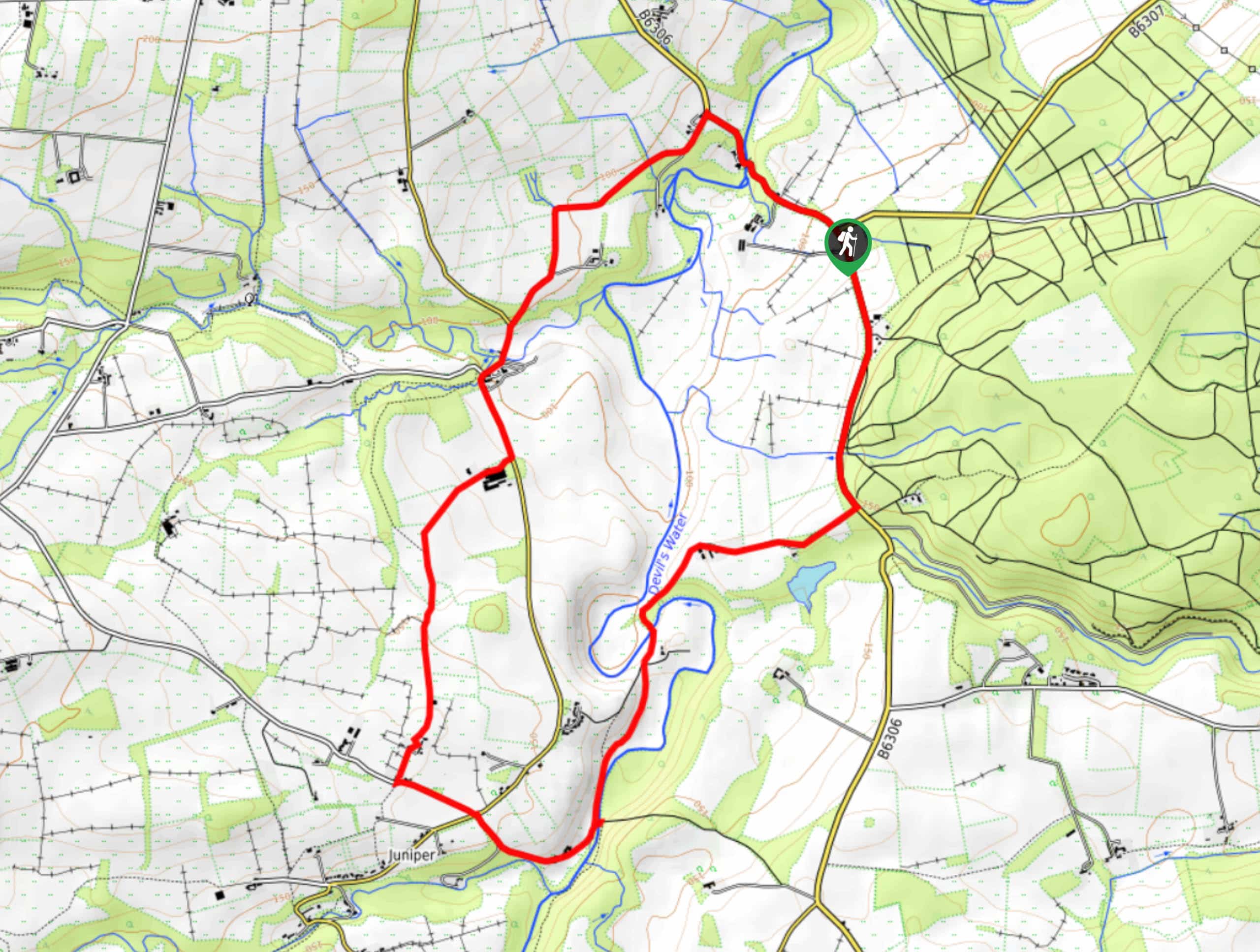
The Devil’s Water Circular Walk is a laidback excursion in Northumberland that will take you through the countryside surrounding a winding river. While out walking the trail you will pass through serene woodlands and open agricultural fields, before making your way across the banks of Devil’s Water at several points. Walkers should take note that part of this route does follow along a fairly busy road, so be sure to exercise caution if travelling with children or dogs.
Getting there
The trailhead for the Devil’s Water Circular Walk can be found 2.3mi southeast of Hexham along B6306.

About
| Backcountry Campground | No |
| When to do | Year-Round |
| Pets allowed | Yes - On Leash |
| Family friendly | Older Children only |
| Route Signage | Average |
| Crowd Levels | Moderate |
| Route Type | Circuit |
Devil’s Water Circular Walk
Elevation Graph
Weather
Devil’s Water Circular Walk Description
If you don’t mind a bit of road walking sprinkled in amongst your adventure through beautiful forests and open fields, then the Devil’s Water Circular Walk is a fun trail for exploring the Northumberland countryside.
Setting out from the trailhead, you will head south along B6306 for a short distance, before breaking off to the southwest through a tranquil stretch of forest. From here, you will pass by several open fields and arrive at the winding banks of Devil’s Water.
After crossing over the beautiful river, you will follow its banks to the south, crossing over the water several more times before climbing uphill and crossing over the road. From here, you will pass through several small forests to the north, eventually turning left along the road to cross over West Dipton burn. Shortly after this, you will break off to the northwest and pass through the forest, crossing over Devil’s Water once more before turning to the southeast along B6306 to return to the trailhead.
Similar hikes to the Devil’s Water Circular Walk hike

Hadrian’s Wall: Steel Rigg to Lanercost
Walking Hadrian’s Wall: Steel Rigg to lanercost is a fantastic - albeit lengthy - adventure that will lead you across…

Hadrian’s Wall: Wallsend to Heddon on the Wall
Hadrian’s Wall: Wallsend to Heddon on the Wall is the first section of the long distance Hadrian’s Wall Path walking…

Scotch Gill Woods Walk
The Scotch Gill Woods Walk is a short and easy-going adventure in Morpeth, Northumberland that will take you through a…
Comments