
Black Walnut and Swayze Falls Loop
View Photos
Black Walnut and Swayze Falls Loop
Difficulty Rating:
Hiking the Black Walnut and Swayze Falls Loop is a fantastic adventure near St. Catherines that will lead you through the beautifully scenic woodland setting of Short Hills Provincial Park. While out hiking the trail, you will loop through serene stretches of forest and experience views overlooking two charming waterfalls. Although there are a few sections with steep terrain, this is a great route for beginner hikers and families that are looking for a fun intermediate length trail.
Getting there
In order to get to the trailhead for the Black Walnut and Swayze Falls Loop from the Brock University Campus in St. Catherines, head south on Merrittville Highway for 0.7mi and turn right onto Decew Road. Continue on for 1.2mi before making a left onto Cataract Road and following it for 1476ft. Turn right onto Wiley Road and you will arrive at the parking lot in 0.7mi.

About
| When to do | Year-Round |
| Backcountry Campsites | No |
| Pets allowed | Yes - On Leash |
| Family friendly | Older Children only |
| Route Signage | Average |
| Crowd Levels | Moderate |
| Route Type | Circuit |
Black Walnut and Swayze Falls Loop
Elevation Graph
Weather
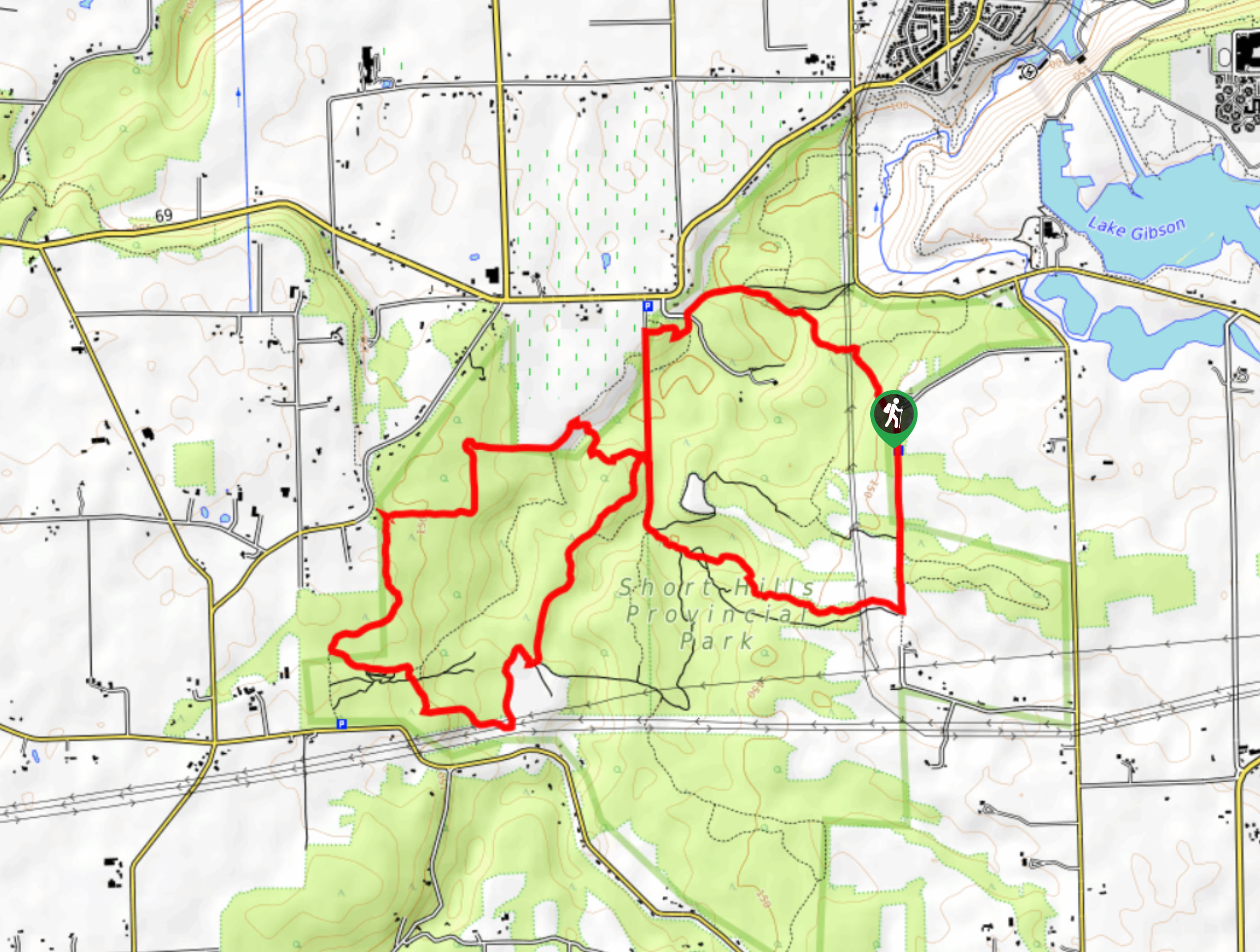
Black Walnut and Swayze Falls Trail Description
As the name suggests, Short Hills Provincial Park features a series of small hills that were formed during the last ice age, meaning that the Black Walnut and Swayze Falls Loop will see you traverse some portions of steep and possibly rugged terrain. These are still manageable for hikers of most skill levels, so make sure to wear proper hiking footwear and take your time in these areas. Additionally, you should try to arrive early for this adventure, as parking at the trailhead may be limited during peak times. After your hike, make sure to check yourself for ticks, as the forest landscape is a prime hiding place for the pesky creatures.
Setting out from the parking lot, head north along Wiley Road and pick up the trail on the left as it breaks away from the road to lead you through the forest. From here, follow the path to the northwest through the undulating forest landscape of the park before it turns to the south along the Black Walnut Trail. After reaching a junction, the trail will break to the west, where you will climb uphill on a forested loop that will bring you to the first waterfall of the hike: Swayze Falls. Take some time to appreciate the beauty of the falls, before following the trail downhill to the northwest. Arriving at the previous junction with the Black Walnut Trail, turn right to climb further uphill and reach another scenic waterfall. From here, continue to the east to reach Wiley Road, following it to the north to return to the parking lot having completed the Black Walnut and Swayze Falls Loop.
Similar hikes to the Black Walnut and Swayze Falls Loop hike
Woodend Conservation Area Loop Hike
The Woodend Conservation Area Loop is a family-friendly hiking route in the Niagara region that will lead you through a…
Niagara River Recreational Trail
Hiking the Niagara River Recreational Trail is a lengthy adventure in Niagara Falls that will take you through the city…
Scarlet Tanager to Hemlock Valley Hike
The Scarlet Tanager to Hemlock Valley Hike is a moderate length route near St. Catherines that will lead you through…
Comments