
Centennial Trail
View Photos
Centennial Trail
Difficulty Rating:
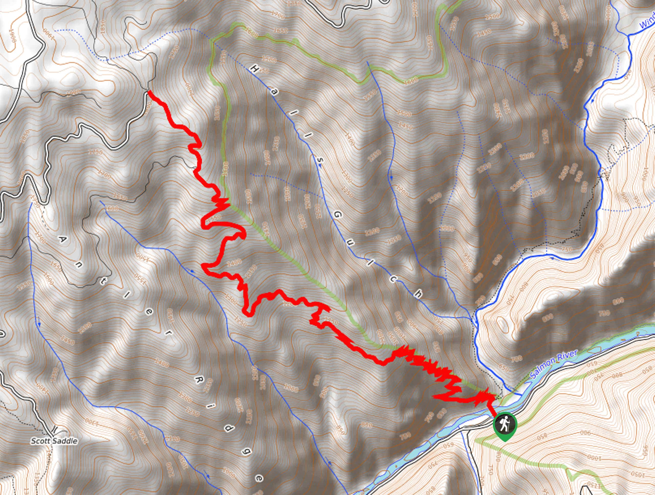
The Centennial Trail is no walk in the park, demanding an arduous up the exposed walls of the Salmon River Canyon. While taxing, this adventure boasts wonderful panoramas of the Salmon River Mountains and that negates the sweat.
Getting there
Access this hike from the Wind River Trailhead off National Forest Development Road 103.

About
| Backcountry Campground | No |
| When to do | March-October |
| Pets allowed | Yes - On Leash |
| Family friendly | No |
| Route Signage | Average |
| Crowd Levels | Moderate |
| Route Type | Out and back |
Centennial Trail
Elevation Graph
Weather
Centennial Trail Description
The Centennial Trail is a long and involved adventure in the Nez Perce National Forest that requires a strong sense of determination and preparation. Beginning in the Salmon River Canyon, this trek travels up into the mountains via countless switchbacks. Due to the vertiginous nature of the path, a sturdy pair of footwear is necessary. Additionally, as the route is exposed to the elements, it is vital you bring enough water for you and your four-legged friend to stay adequately hydrated. Note the are sections of the trail that are quite overgrown, so long pants are recommended.
Setting out from the Wind River Trailhead, you will be guided across the picturesque Salmon River via a footbridge. After crossing the bridge, you will confront an intersection; veer left here onto the Idaho Centennial Trail. Immediately after departing the junction, the pitch will intensify, demanding a sweat. As you navigate the seemingly never-ending set of switchbacks, you will be rewarded with breathtaking views of the valley behind you and the nearby Salmon River Mountains.
Take your time and mind your footing as you maneuver the winding path up the vertiginous slope. Near the end of the route, you will confront an intersection, keep right, and trek up to the trail’s end at Sand Creek Road. Pat yourself on the back for the accomplishment you just achieved, and revel in the grandeur of the dramatic landscape. Retrace your footing back down to the trailhead when you are rested and rehydrated.
Similar hikes to the Centennial Trail hike
Upper Cannon Lake Hike
The Upper Cannon Lake Hike is a long and involved adventure into the Seven Devils Mountains in the Nez Perce…
Johns Creek Loop Hike
Immerse yourself in an old-growth forest along the Johns Creek Loop Hike. While this route is long, the incredible mountainous…
Cupboard Creek Trail
The Cupboard Creek Trail is a beautiful trail that leads intrepid adventurers into the Selway River Canyon. The wild character…
Comments