
Silver Falls Hike
View Photos
Silver Falls Hike
Difficulty Rating:
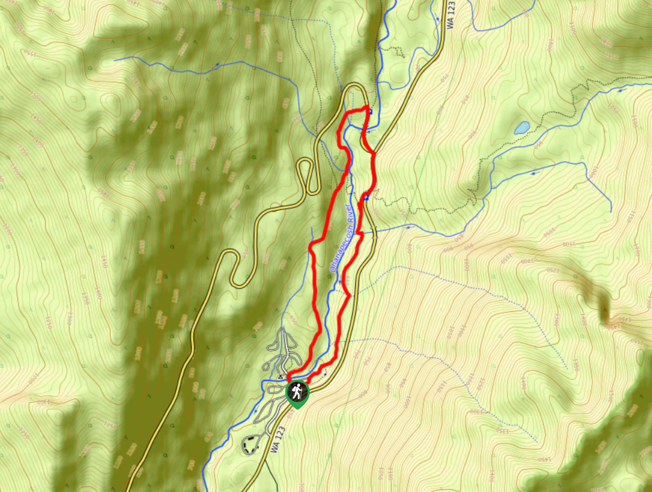
The Silver Falls hike is a 3.0mi family-friendly hike in the southeastern portion of Mount Rainier National Park that takes you to a cascading waterfall and that can be easily linked with the popular Grove of the Patriarchs trail. The hike requires little elevation gain and the trail is wide, making it a nice choice for families.
Years ago, visitors flocked to the waterfalls to soak in the springs, which were believed to have healing properties. You’re not allowed to swim in them anymore, but you can read the collection of interpretive signs along the trail that highlight the history of this spot.
Getting there
To get to the Silver Falls trailhead from Packwood, drive east on Highway 12 for about 8.0mi to the junction with Highway 123. Turn north onto Highway 123, driving 3.5mi to the Ohanapecosh Campground. Turn left into the grounds and follow the signage for the day use area. If the day use area is full, you can stop at the Visitor Center and see if there is open day use parking nearby.

About
| Backcountry Campground | Ohanapecosh |
| When to do | May-September |
| Backcountry Campsites | Ohanapecosh |
| Pets allowed | No |
| Family friendly | Yes |
| Route Signage | Average |
| Crowd Levels | Moderate |
| Route Type | Lollipop |
Silver Falls Hike
Elevation Graph
Weather
Silver Falls Hike Description
The Silver Falls hike is a family-friendly, pretty hike to a waterfall in Mount Rainier National Park. With wide trails, little elevation gain, and signage to follow, it’s an easy, quick outing for visitors to the southeastern portion of the park. The parking for the trail can fill, so we recommend coming earlier in the morning or later in the afternoon.
The Silver Falls hike begins at the northeastern end of Loop B in the Ohanapecosh background, right next to campsite B2. Follow the riverbank and walk into the forest along a wide path. At 0.1mi, the Ohanapecosh Hot Springs Trail splits off to the right, so follow the signage for Silver Falls.
Walking through the forest, you’ll gain gentle elevation to a viewpoint over the river and the falls. Watch the white water cascade over the rocks, the mist nice and refreshing on a hot day. As you switchback down a bridge over the river, you’ll earn a nice view of the waterfall and river below you. Enjoy this portion of the hike before departing the falls area.
Once you’re past the bridge, go left along the trail as it leads through the forest. You’ll walk alongside the river for a bit, then turn away from it. Walk through the trees for a mile and a half to the amphitheater at Ohanapecosh. Here, you’ll join the road and walk back to the parking area where you began.
The nearby Grove of the Patriarchs trail is an easy family-friendly addition to this hike.
Frequently Asked Questions
Are there hot springs on the Silver Falls hike?
The hot springs that used to attract visitors to the park have been allowed to revert back to their natural state. There are no longer soaking pools to use, but you can take a swim in the river if you feel so inclined.
Can I camp near Silver Falls?
The trailhead for the Silver Falls hike is in the Ohanapecosh Campground. You’ll need to book your site ahead of time.
Insider Hints
Although tempting to walk on for little ones, the rocks around the falls are very wet and slippery. Supervise kids closely!
This trail is susceptible to washout in certain parts. Check conditions online before visiting, especially in the spring or after significant rains.
This is a perfect hike to enjoy if you’re staying in the Ohanapecosh Campground.
Similar hikes to the Silver Falls Hike hike
Twin Firs Loop Trail
Twin Firs Loop is a 0.3mi hike in Mount Rainier National Park that is incredibly easy, making it…

Paul Peak Trail
The Paul Peak Trail is a 6.3mi lightly trafficked out and back trail in Mount Rainier National Park…

Narada Falls to Mazama Ridge Loop
The Narada Falls to Mazama Ridge loop is an 7.4mi moderately trafficked route in Mount Rainier National Park…
Comments