
Surprise and Glacier Lakes via Surprise Creek Trail
View Photos
Surprise and Glacier Lakes via Surprise Creek Trail
Difficulty Rating:
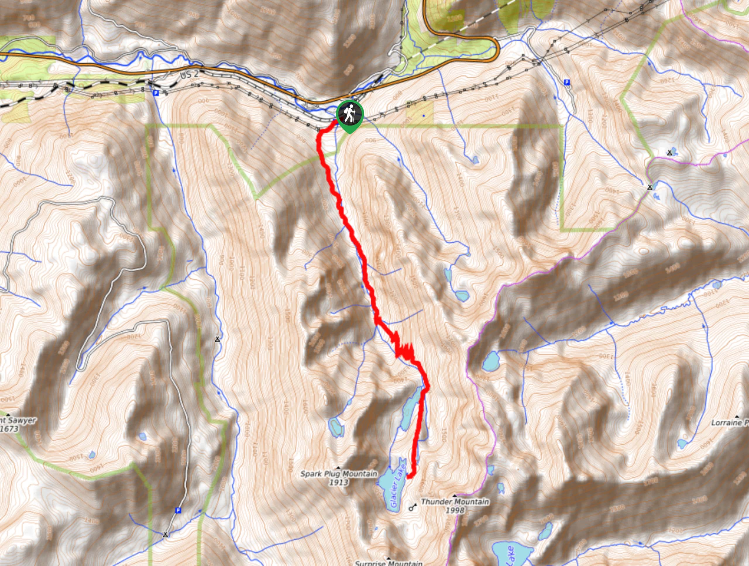
Surprise Lake and Glacier Lakes are reached on Surprise Creek Trail on this hard hike. At 16.1km and with 2963ft of elevation gain, this hike is a solid day’s effort. You’ll enjoy the beauty of two alpine lakes and the mountains that surround them on this trail. You can also use this hike to continue on up Thunder Mountain or Surprise Mountain.
Getting there
The trailhead for the hike to Surprise and Glacier Lakes on Surprise Creek Trail is off Highway 2 on an access road just west of Old Cascade Highway.

About
| Backcountry Campground | No |
| When to do | July-October |
| Pets allowed | Yes - On Leash |
| Family friendly | No |
| Route Signage | Average |
| Crowd Levels | Moderate |
| Route Type | Out and back |
Surprise and Glacier Lakes via Surprise Creek Trail
Elevation Graph
Weather
Surprise and Glacier Lakes via Surprise Creek Trail Description
The hike to Surprise Lake and Glacier Lake on Surprise Creek Trail is a beautiful trek, and it’ll leave you feeling satisfied with a full day’s effort. You can also use this trail to ascend either Thunder or Surprise mountains.
Begin from the end of the road near Scenic Creek, crossing the creek and keeping left at an intersection with a spur trail. You’ll follow alongside Surprise Creek on a trail that is mostly level, to begin with.
You’ll cross the creek just before it forks, then cross back over another arm to hike with the water now on your right. The trail soon begins to ascend, with switchbacking turns leading you up to Surprise Lake. There can sometimes be downed trees here from avalanche damage, so take your time crossing them if they’re present.
There is a fork on the lakeshore with a short trail that leads you more directly along the shore, but this trail doesn’t reconnect to the main trail, so you’ll have to backtrack if you take it.
Continue onto the PCT, keeping right at the next intersection and then left to the lakeshore of Glacier Lake. This is where the trail ends, so you can either retrace your steps or continue exploring.
Similar hikes to the Surprise and Glacier Lakes via Surprise Creek Trail hike

Lakes Dorothy, Bear, Deer, and Snoqualmie Hike
The Lakes Dorothy, Bear, Deer, and Snoqualmie Hike provides access to Lake Dorothy, Bear Lake, Deer Lake, and Snoqualmie Lake.…

Gold Creek Trail to Joe Lake
Gold Creek Trail to Joe Lake is not a hike for the faint of heart. This lightly trafficked trail is…

Basin Lake via Bullion Basin Trail
Basin Lake via Bullion Basin Trail is a 12.2mi hike that, with 2900ft of elevation gain,…
Comments