
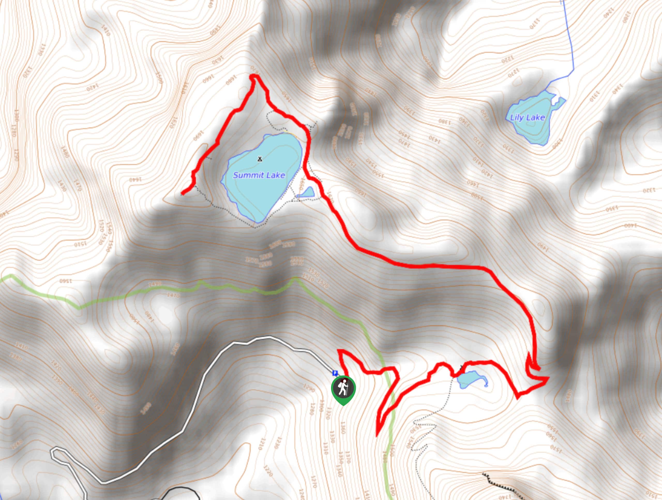
Summit Lake Trail
View Photos
Summit Lake Trail
Difficulty Rating:
The Summit Lake Trail is a 5.7mi heavily trafficked out and back trail in Clearwater Wilderness that is rated as moderate. This pretty trail offers excellent views for relatively little effort, and the numerous camping spots along the way make it an ideal first backpacking trip. You can extend your trip by heading down the nearby Bearhead Mountain Trail, or just stick to Summit Lake for a satisfying day hike. This hike actually features two lakes, but the star of the show is Mount Rainier peaking over Summit Lake.
The road to the trailhead is covered in large potholes and can become overgrown, so we recommend a high-clearance vehicle and a slow approach.
Getting there
The trailhead for the Summit Lake Trail is at the end of FR 7810. It’s about 6.8mi past the left turn off of Cayada Creek Road.

About
| Backcountry Campground | Summit Lake Camping Area, Twin Lake Backcountry Camp |
| When to do | May-October |
| Pets allowed | Yes - On Leash |
| Family friendly | No |
| Route Signage | Average |
| Crowd Levels | High |
| Route Type | Out and back |
Summit Lake Trail
Elevation Graph
Weather
Summit Lake Trail Description
Summit Lake is a local go-to for hikers looking to take their visiting friends and family out, a testament to its accessible but still rewarding nature. With a moderate effort required, you can savour views of Mount Rainier rising over the blue waters of the lake. An endless panorama of peaks surrounds this view, making it a knockout objective. This trail also has lots of camping along the way, making it a great choice for new backpackers or those seeking a quick, simple weekend out.
The road to the trail is in poor condition, with lots of potholes and overgrown branches. Drive with caution and take a higher clearance vehicle if you’re able to.
The hike begins by climbing through a young forest, which slowly gives way to a more mature group of trees. You’ll take wide switchbacks up the side of the mountain that offer a gradual climb.
About 1.0mi, you’ll arrive at a junction with the Carbon River Trail and Twin Lake. You can take the short, unmarked trail to the little lake, but you’ll find that this lake not only is twinless, but doesn’t offer a whole lot in the way of views.
Continue along the main trail, where the elevation gain intensifies a bit. You’ll climb up the ridgeline, entering into a green meadow about 2.5mi into the hike. Summit Lake is nestled into the middle of the meadow, and in wildflower season, the view is even more spectacular. Keep an eye out for wildlife in this meadow. Some locals might be more skittish (like herds of deer), but bears sometimes like to hang out here.
We recommend continuing on where the trail splits into a loop, circling the lake and cresting Summit Lake Peak. The view from here is the best you can find on this hike, but if you’re not feeling up to it, the meadow is still lovely. Note that this trail is a bit rough and steep.
Count more peaks than you can keep track of, then turn around and retrace your steps back to the trailhead.
Hiking Route Highlights
Mount Rainier
The gem of the view from Summit Lake is Mount Rainier, the tallest mountain in Washington and a mighty sight from any angle. This 14,410-foot stratovolcano rises above the shores of the lake surrounded by many other mountains.
Frequently Asked Questions
Can you swim at Summit Lake?
Yes, although the water might be chilly!
Is Summit Lake in Mount Rainier National Park?
The lake is just north of the park, not within its boundaries. This is important to consider when ensuring you have the correct pass to enjoy the hike.
Do I need a pass to hike Summit Lake?
Yes, please have your Northwest Forest Pass ready for this hike.
Insider Hints
This hike is even better when the wildflowers are in bloom, which tends to be mid-July through mid-August.
Try to save this hike for a clear day for the best possible views.
The trail is rooty in parts, so good boots are helpful to have.
Similar hikes to the Summit Lake Trail hike

Lakes Dorothy, Bear, Deer, and Snoqualmie Hike
The Lakes Dorothy, Bear, Deer, and Snoqualmie Hike provides access to Lake Dorothy, Bear Lake, Deer Lake, and Snoqualmie Lake.…

Gold Creek Trail to Joe Lake
Gold Creek Trail to Joe Lake is not a hike for the faint of heart. This lightly trafficked trail is…

Basin Lake via Bullion Basin Trail
Basin Lake via Bullion Basin Trail is a 12.2mi hike that, with 2900ft of elevation gain,…
Comments