
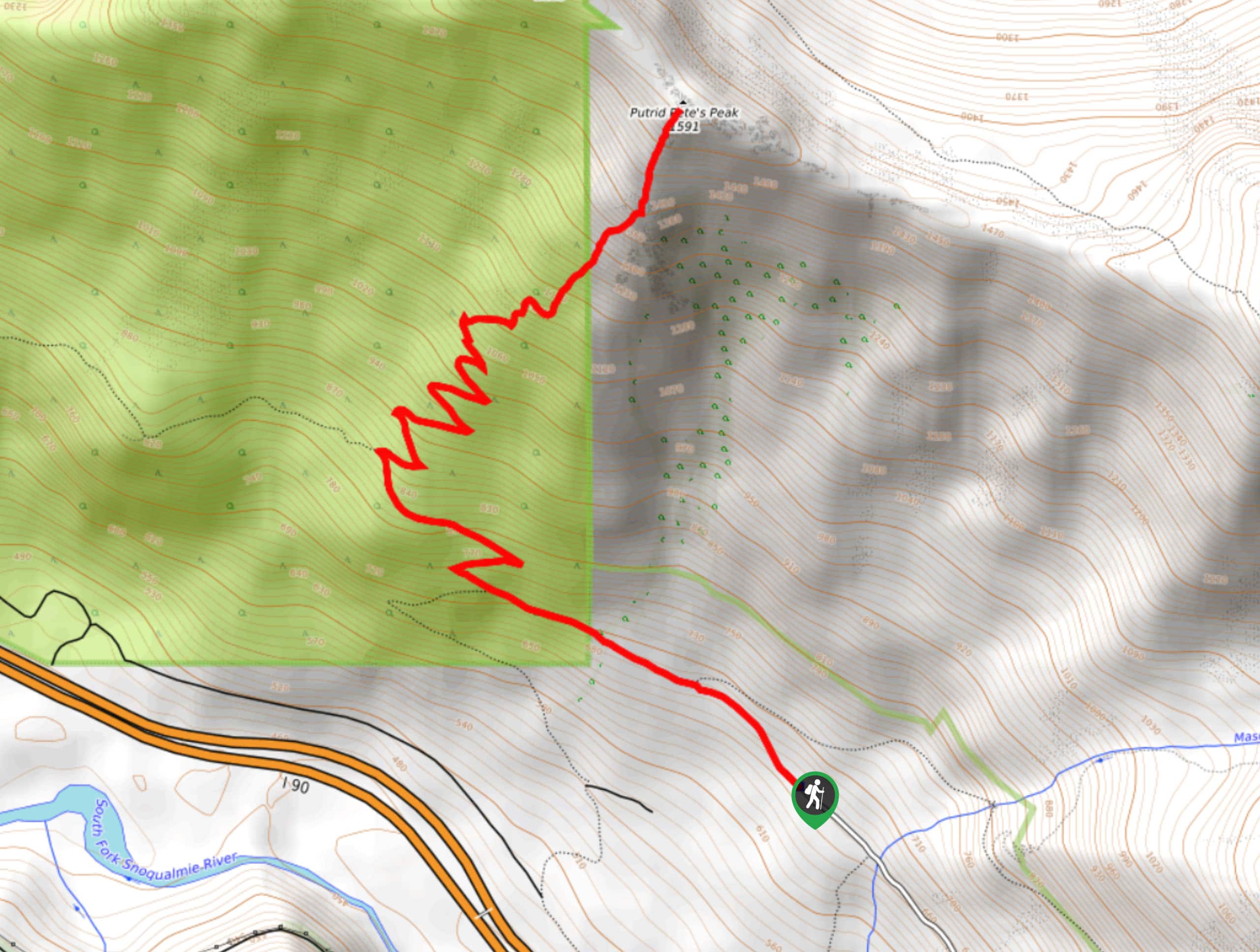
Putrid Pete’s Peak Trail
View Photos
Putrid Pete’s Peak Trail
Difficulty Rating:
Putrid Pete’s Peak Trail (sometimes referred to as P3) is a fun hike in Mount Baker-Snoqualmie National Forest. This hike has a spectacular summit view reached on a steep final ascent. Expect Class !!+ scrambling and some exposure. If you’re not a fan of heights, we’d skip this one. If you love an adventure, we recommend it! The trail also enjoys less traffic than others in the area.
Getting there
The trailhead for Putrid Pete’s Peak is at the Ira Spring trailhead at the end of Mason Lake Road.

About
| Backcountry Campground | No |
| When to do | June-October |
| Pets allowed | Yes - On Leash |
| Family friendly | No |
| Route Signage | Average |
| Crowd Levels | Moderate |
| Route Type | Out and back |
Putrid Pete’s Peak Trail
Elevation Graph
Weather
Putrid Pete’s Peak Trail Description
Putrid Pete’s Peak Trail is a fun hike in Mount Baker-Snoqualmie perfectly suited to the adventurous intermediate hiker. WIth a steep climb and a scramble required to reach the exposed, small peak, it’s a thrilling hike without requiring an all-day commitment.
Begin from the Ira Spring Trailhead. Keep an eye on the map so you don’t miss where P3 splits off from Ira Spring- you’ll be keeping on roughly straight while the other trail takes a sharper right-hand turn.
The first portion of the trail is very gradual and relaxed. Enjoy it while it lasts, because once the switchbacks start, you’ll be huffing and puffing. Stay right at two junctions as you ease into the turns.
Grind through the switchbacks, poking out of the trees to take a ridgewalk over to the summit. The scrambling is a bit exposed but most of it feels safe enough for most hikers. The summit area itself is very small, but you’ll be able to appreciate the views from just below it as well.
Once you’re ready, you’ll retrace your steps back to the trailhead.
Similar hikes to the Putrid Pete’s Peak Trail hike

Lakes Dorothy, Bear, Deer, and Snoqualmie Hike
The Lakes Dorothy, Bear, Deer, and Snoqualmie Hike provides access to Lake Dorothy, Bear Lake, Deer Lake, and Snoqualmie Lake.…

Gold Creek Trail to Joe Lake
Gold Creek Trail to Joe Lake is not a hike for the faint of heart. This lightly trafficked trail is…

Basin Lake via Bullion Basin Trail
Basin Lake via Bullion Basin Trail is a 12.2mi hike that, with 2900ft of elevation gain,…
Comments