
Glacier Basin via Monte Cristo Trail
View Photos
Glacier Basin via Monte Cristo Trail
Difficulty Rating:
Glacier Basin is a stunning spot, and the route to it via Monte Cristo Trail can either be a hard day trip or a backpacking trip with tons of options for campsites. This trail is moderately trafficked and requires some scrambling at the end. Bring plenty of water and come prepared for portions of the trail without shade, although it’s worth doing on a sunny day for the best possible views at the basin.
Getting there
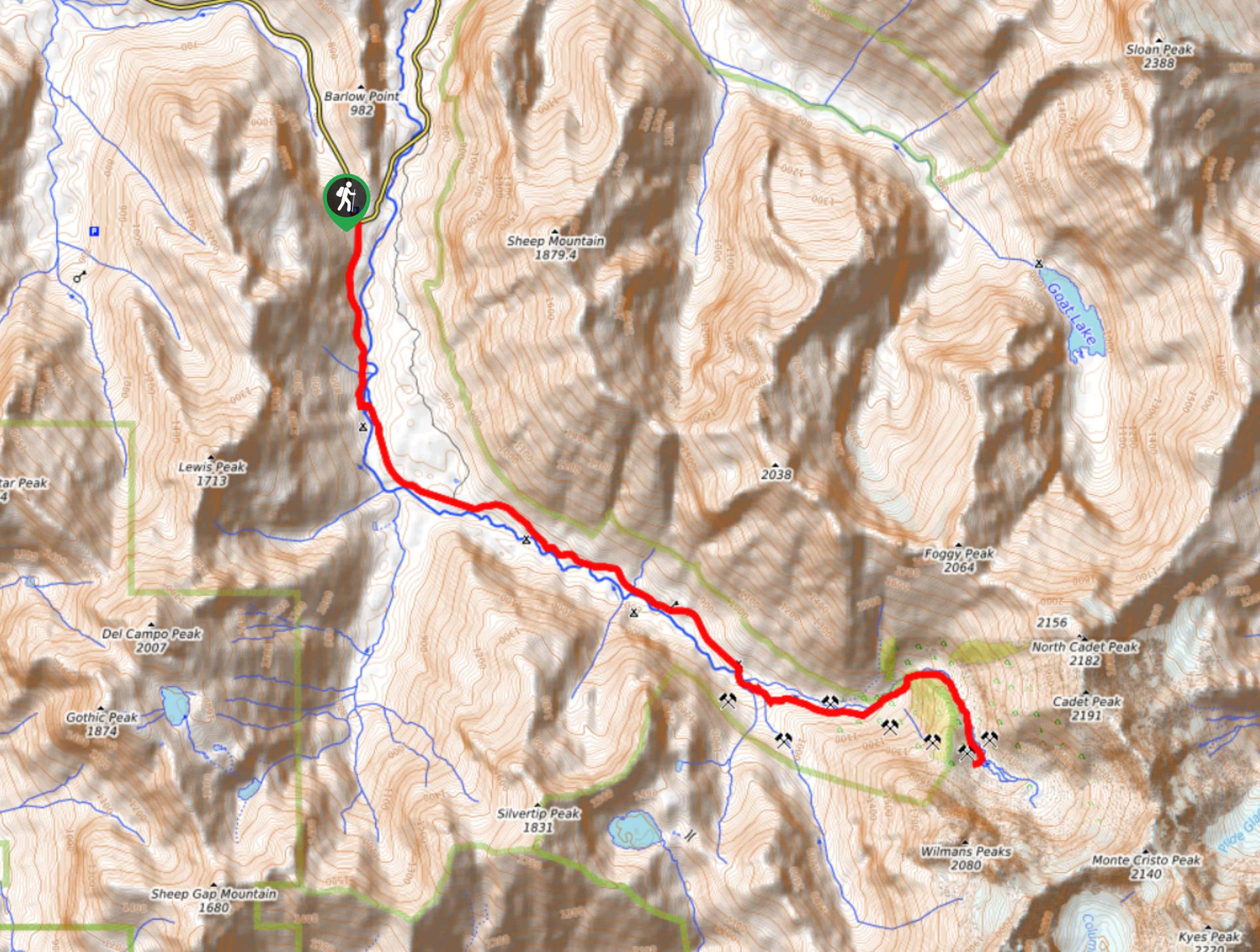
The trailhead for the hike to Glacier Basin on Monte Cristo Trail is at the Barlow Pass Trailhead on Mountain Loop highway just south of Barlow Pass.

About
| Backcountry Campground | Hops Hill, Sauk River, Twin Bridge, Monte Cristo |
| When to do | June-November |
| Pets allowed | Yes - On Leash |
| Family friendly | Yes |
| Route Signage | Average |
| Crowd Levels | High |
| Route Type | Out and back |
Glacier Basin via Monte Cristo Trail
Elevation Graph
Weather
Glacier Basin via Monte Cristo Trail Description
Oh, Glacier Basin. This is a gorgeous destination worth the effort required to reach it on Monte Cristo Trail. This approach is long and requires some scrambling, but a flatter start and the opportunity to break it up into a backpacking trip make it very doable. Some people ride their bikes to Monte Cristo to speed up the hike, which is a good option if you’re wanting to be on foot for less than 13.0mi.
The hike begins from the Barlow Pass trailhead area. Head south to take Monte Cristo Trail as it follows the South Fork Souk River. There are a few junctions- just keep straight. You’ll cross the river a few times on bridges.
Arriving in Monte Cristo, pay attention to the signage to get to Dumas Street Trail, then turn right onto Glacier Basin Trail. As you hike to the end of Glacier Creek and beyond, it gets harder and steeper, climbing 2000ft or in 2.0mi.
There is a scramble approaching the basin that has had a rope present to assist previously, but don’t count on the rope always being there (it may wear away eventually and may or may not be replaced). Take your time, especially if it’s slick.
Enjoy the basin before retracing your steps through Monte Cristo to the trailhead. Thankfully, the downclimb on the scramble generally isn’t too challenging.
Similar hikes to the Glacier Basin via Monte Cristo Trail hike

Lakes Dorothy, Bear, Deer, and Snoqualmie Hike
The Lakes Dorothy, Bear, Deer, and Snoqualmie Hike provides access to Lake Dorothy, Bear Lake, Deer Lake, and Snoqualmie Lake.…

Gold Creek Trail to Joe Lake
Gold Creek Trail to Joe Lake is not a hike for the faint of heart. This lightly trafficked trail is…

Basin Lake via Bullion Basin Trail
Basin Lake via Bullion Basin Trail is a 12.2mi hike that, with 2900ft of elevation gain,…
Comments