
Change Creek Trail
View Photos
Change Creek Trail
Difficulty Rating:
The Change Creek Trail is a lightly trafficked out-and-back route in Mount Baker-Snoqualmie National Forest that is rated as hard. This trail earns its rating partly for a steep first half of the hike and partly because the second half of the trail is very overgrown. While routefinding shouldn’t be too much of a challenge, you will need to bushwhack to reach the calm pond at the end of this trail. Also, you’ll likely have the place to yourself!
Getting there
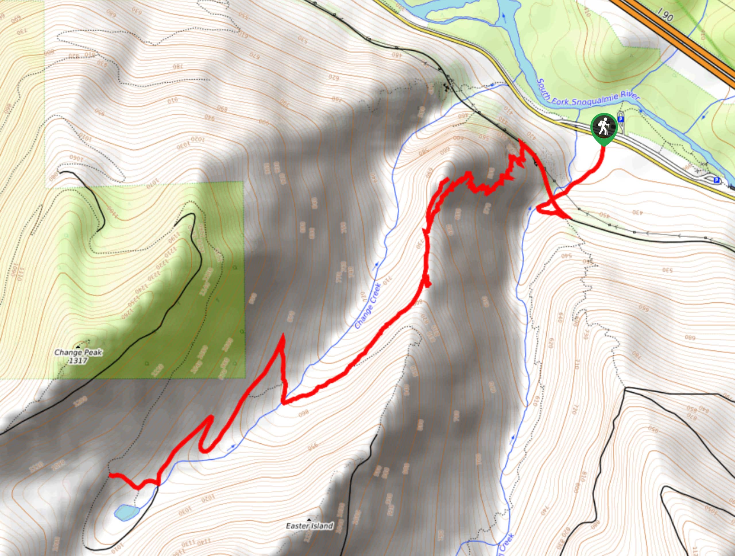
The trailhead for the Change Creek Trail is across from the Olallie State Park South Fork Picnic Area on SE Homestead Valley Road.

About
| Backcountry Campground | No |
| When to do | May-October |
| Pets allowed | Yes - On Leash |
| Family friendly | Older Children only |
| Route Signage | Average |
| Crowd Levels | Low |
| Route Type | Out and back |
Change Creek Trail
Elevation Graph
Weather
Change Creek Trail Description
Change Creek Trail is one for the hiker who wants to get away from the crowds and is okay taking on a wilder trail to do it. This hike tends to be quiet, and it’s very pretty and a nice mid-distance. However, the challenge comes on the second half of the hike, when you’ll be dealing with a severely overgrown trail very overdue for a good pair of clippers. Wear long pants and long sleeves if you can.
The first half of the trail is steep, beginning with a short walk up from the road with a nice view of the Change Creek Bridge. Climb up to the bridge and go left (west) to find the trailhead at the end of the next bridge. Head up, taking one of the short spur trails for a view of the valley if you please.
After you reach Hall Point, turn onto an old forest road. This is where the overgrowth begins. While the trail remains easy enough to follow, you’ll get a spider web in the face if you’re not very careful. Make it through, turning off the road at the signage for the pond. At the pond, retrace your steps back to the trailhead.
Similar hikes to the Change Creek Trail hike

Lakes Dorothy, Bear, Deer, and Snoqualmie Hike
The Lakes Dorothy, Bear, Deer, and Snoqualmie Hike provides access to Lake Dorothy, Bear Lake, Deer Lake, and Snoqualmie Lake.…

Gold Creek Trail to Joe Lake
Gold Creek Trail to Joe Lake is not a hike for the faint of heart. This lightly trafficked trail is…

Basin Lake via Bullion Basin Trail
Basin Lake via Bullion Basin Trail is a 12.2mi hike that, with 2900ft of elevation gain,…
Comments