
Bear Gap to Bullion Basin Hike
View Photos
Bear Gap to Bullion Basin Hike
Difficulty Rating:
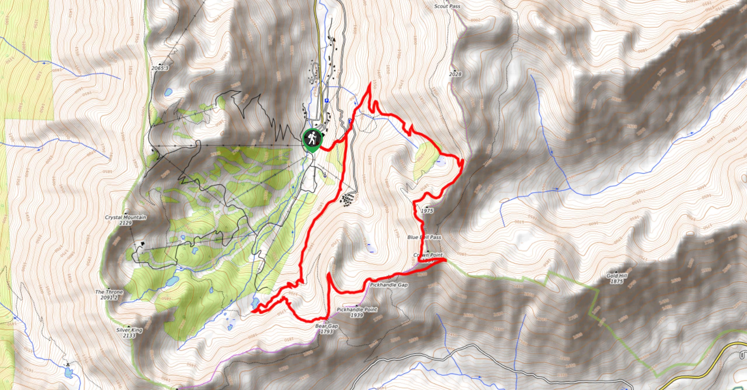
Bear Gap to Bullion Basin is a 7.6mi hike that, with 2185ft of elevation gain, is considered moderate. This hike takes the better part of the day but isn’t too challenging, and the lack of foot traffic allows you more solitude than most trails. With an abandoned mine shaft to check out and ever-changing views, this loop is worth doing if you’re in the Crystal Mountain area.
Getting there
The trailhead for the Bear Gap to Bullion Basin loop is just north of the chapel in Crystal Mountain.

About
| Backcountry Campground | No |
| When to do | June-September |
| Pets allowed | Yes - On Leash |
| Family friendly | No |
| Route Signage | Average |
| Crowd Levels | Low |
| Route Type | Loop |
Bear Gap to Bullion Basin Hike
Elevation Graph
Weather
Bear Gap to Bullion Basin Hike Description
Bear Gap to Bullion Basin is a good mid-difficulty hike that is easily accessible from Crystal Mountain. The views change along the way, getting better and better, and you won’t be fighting for space with anyone on this quiet trail. Most hikers go counterclockwise.
The hike begins from the road beside the chapel, heading out back on the Gold Hill Road East. The first 14 minutes or so are very straightforward. You’ll go straight through a 5-way junction, then take Silver Creek Trail south at the next junction. Stop into the abandoned mine shaft, then keep going to a T-junction, where you’ll stay right. Stay left at the next, passing through a meadow to Henskin Lake.
Take a sharp left past the lake, hiking to Bear Gap. Here, hop on the PCT going northeast to Crown Point. At the junction with Bullion Basin trail, keep left to get off the PCT. Stay on this trail until you’re back at the junction with Gold Hill Road East, which you’ll take back to the trailhead.
Similar hikes to the Bear Gap to Bullion Basin Hike hike

Lakes Dorothy, Bear, Deer, and Snoqualmie Hike
The Lakes Dorothy, Bear, Deer, and Snoqualmie Hike provides access to Lake Dorothy, Bear Lake, Deer Lake, and Snoqualmie Lake.…

Gold Creek Trail to Joe Lake
Gold Creek Trail to Joe Lake is not a hike for the faint of heart. This lightly trafficked trail is…

Basin Lake via Bullion Basin Trail
Basin Lake via Bullion Basin Trail is a 12.2mi hike that, with 2900ft of elevation gain,…
Comments