Annette Lake Trail
View Photos
Annette Lake Trail
Difficulty Rating:
Annette Lake Trail is a 7.8mi heavily trafficked out and back trail in Mount Baker-Snoqualmie National Forest that is rated as moderate. This trail is very beautiful, with a variety of scenery to enjoy year-round (though best experienced in the summertime). You’ll see waterfalls, shady forest, alpine lakes, and mountains in all their glory. This hike is an excellent moderate outing, making it suitable for older children and beginner-intermediate hikers, or more experienced adventurers seeking a more relaxed adventure. This is also a popular trail with backpackers hiking in to camp at the lake.
Bring bug spray for this trail.
Getting there
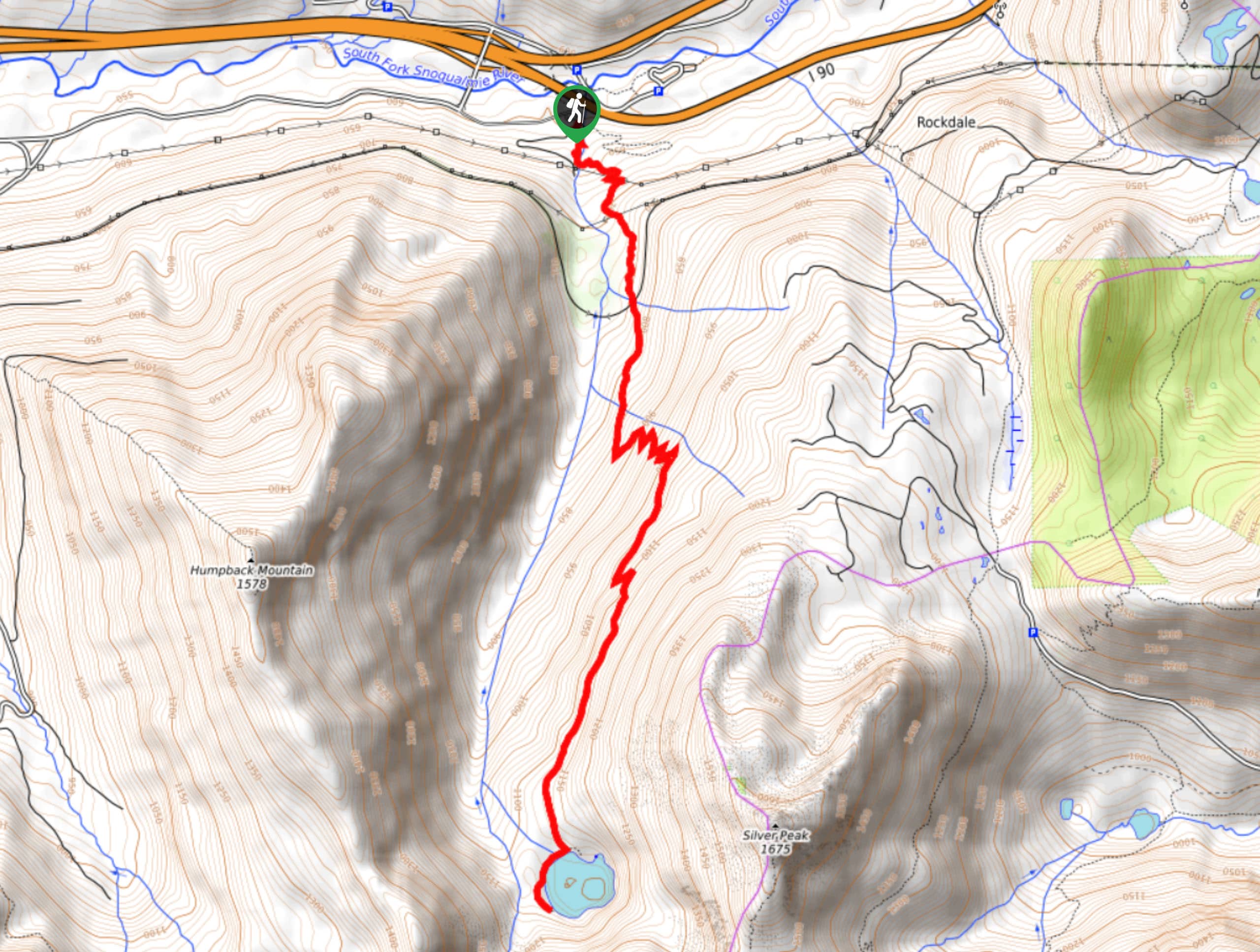
The trailhead for Lake Annette Trail is on FR 5590 0.3mi from the exit off the highway. Watch for the signed parking area.

About
| Backcountry Campground | No |
| When to do | June-October |
| Pets allowed | Yes - On Leash |
| Family friendly | Older Children only |
| Route Signage | Good |
| Crowd Levels | High |
| Route Type | Out and back |
Annette Lake Trail
Elevation Graph
Weather
Lake Annette Trail Description
The hike to Lake Annette packs plenty of natural beauty into a mid-distance trail, offering a quintessential Snoqualmie experience suitable for a variety of skill levels. Beginner backpackers can hike in to stay at the lake, and day-trippers can enjoy a splash in the impossibly clear waters. The trail does get quite busy on weekends, so we recommend a midweek or early morning trip if you can swing it.
Bring bug spray for this hike, and watch for bees and wasps. Some hikers report being stung on this trail.
The hike begins from the parking area, just right of the information kiosk. Make sure you don’t take the Asahel Curtis Nature Trail by accident. The forest wraps you up, with towering cedars, hemlock, and Douglas fir all around.
In 0.2mi, you’ll cross Humpback Creek. This creek has one of the best tumbling waterfalls in the state, so take a moment to enjoy the cascading water.
Continuing on from the falls, the trail leads through the forest a while longer before breaking into an open area. Your route crosses the Iron Horse Trail at 1.2mi. From here on, a moderate but consistent elevation gain begins.
You’ll cross the occasional small creek, but none of the crossings are difficult or too deep. As you gain elevation, appreciate the wildflowers that line the trail, particularly near the streams.
Your view expands as you cross talus slopes, and you’ll be able to spot Granite Mountain and Humpback Mountain. You’ll re-enter the forest at the end of the final talus slope. This final section of trail evens out nicely.
Approaching the northern shore of Annette Lake, Abiel Peak and Silver Peak rise over the water. A waterfall flows into the lake on the eastern shore, adding to the ambiance. You can pick a spot to settle in for a while, or head east to the camping sites.
When you’re ready, retrace your steps back to the trailhead.
Hiking Route Highlights
Annette Lake
Annette Lake is a gorgeous glacier-fed lake that is used for camping, hiking, and swimming. The lake freezes over in the winter and thaws to glassy-clear in the summer, making it a wonderful destination to explore throughout the year.
Frequently Asked Questions
Can you swim in Annette Lake?
Yes, you can swim in Annette Lake, but as it’s glacier-fed, so it will likely be chilly!
What pass do I need for Annette Lake Trail?
Please have your Northwest Forest Pass ready for this hike.
Insider Hints
Get here early in the morning or later in the afternoon for a quieter trail.
The road to the trailhead is potholed, so a high-clearance vehicle is recommended.
Bring microspikes and poles if hiking here in the wintertime.
Similar hikes to the Annette Lake Trail hike

Lakes Dorothy, Bear, Deer, and Snoqualmie Hike
The Lakes Dorothy, Bear, Deer, and Snoqualmie Hike provides access to Lake Dorothy, Bear Lake, Deer Lake, and Snoqualmie Lake.…

Gold Creek Trail to Joe Lake
Gold Creek Trail to Joe Lake is not a hike for the faint of heart. This lightly trafficked trail is…

Basin Lake via Bullion Basin Trail
Basin Lake via Bullion Basin Trail is a 12.2mi hike that, with 2900ft of elevation gain,…
Comments