

Paradise Falls Hike
View PhotosParadise Falls Hike
Difficulty Rating:
The Paradise Falls Hike is a short, but beautifully scenic, hiking route in Southern California that will take you to a cascading waterfall. While out on the trail, you will meander along a well-maintained network of paths, before meeting up with the banks of Arroyo Conejo and following its banks to reach Paradise Falls. Be sure to arrive early for this adventure, as parking at the trailhead can fill up quickly.
Getting there
The trailhead for the Paradise Falls Hike can be found at the Wildwood Regional Park Trailhead, just off W Avenida de Los Arboles.
About
| Backcountry Campground | No |
| When to do | Year-Round |
| Pets allowed | Yes - On Leash |
| Family friendly | Yes |
| Route Signage | Average |
| Crowd Levels | High |
| Route Type | Circuit |
Paradise Falls Hike
Elevation Graph
Weather
Paradise Falls Hike Description
The Paradise Falls Hike is a fairly easy-going outdoor adventure; however, there are a few things to take into consideration before setting out. You will want to make sure that you wear comfortable hiking shoes, as some sections of the trail can be a bit rocky/uneven. Additionally, you will want to wear appropriate clothing and sunscreen to protect yourself from the sun, as there is not much shade along the trail.
Featuring a relatively short overall distance and scenic terrain, the Paradise Falls Hike makes for a great outing if you are looking to take in the natural beauty of Southern California. Several picnic areas can also be found along the trail, which are ideal for taking a break from the extensive network of trails found in Wildwood Regional Park.
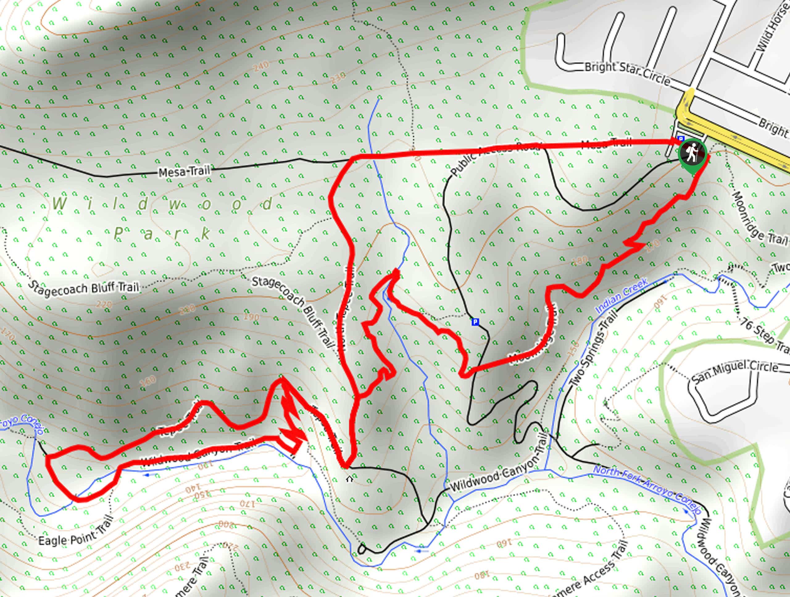
Setting out from the trailhead, you will make your way west along the Mesa Trail for 0.4mi and turn left at the fork in the path. Here, you will begin hiking south along the North Teepee Trail, following it for 0.4mi to reach a junction.
Turning right here, you will follow the Teepee Trail for 0.5mi to a junction, where you will turn left to meet up with the banks of Arroyo Conejo. At this point, the trail will turn back to the east through Sycamore Flats to reach the viewpoint for Paradise Falls.
Take your time here to rest and experience the beautifully scenic views of the cascading waterfall, before continuing on with the remainder of your hike. Following the trail north for a short distance, you will eventually turn right onto the Teepee Trail, keeping left along it for 0.2mi to arrive at another junction.
Turning right at the fork, you will make your way across a stream, following the Moonridge Trail to the northeast to eventually arrive back at the trailhead head where you began your adventure.
Trail Highlights
Paradise Falls
Situated along Arroyo Conejo in Thousand Oaks, Paradise Falls is a 40ft tall waterfall that cascades into a large pool of water. The falls can be found within Wildwood Regional Park, which features a fairly extensive and well-maintained network of trails, enabling easy accessibility from almost anywhere in the park.
Frequently Asked Questions
Can I bring my dog to Paradise Falls?
Yes, dogs are allowed on the Paradise Falls Hike, although they must be kept on a leash at all times.
Are there other things to do near Paradise Falls?
In addition to the vast network of trails, the Paradise Falls Hike also passes by several picnic/recreation areas, allowing you to enjoy the beautiful outdoors of Wildwood Regional Park.
Insider Hints
Be sure to wear comfortable hiking footwear.
Keep your dog on a leash at all times.
Arrive early to secure parking.
Similar hikes to the Paradise Falls Hike hike

Rivas Canyon Trail
Hiking the Rivas Canyon Trail is a wonderful experience near Los Angeles that will take you through a canyon for…

Sullivan Canyon Loop Hike
Hiking the Sullivan Canyon Loop is a moderate-length adventure in Los Angeles that traverses a tricky bit of canyon terrain.…

Bee Rock Loop Hike
The Bee Rock Loop Hike is a quick outdoor adventure that will see you loop around Griffith Park. While out…


Comments