Butte Lake to Snag Lake Loop
View Photos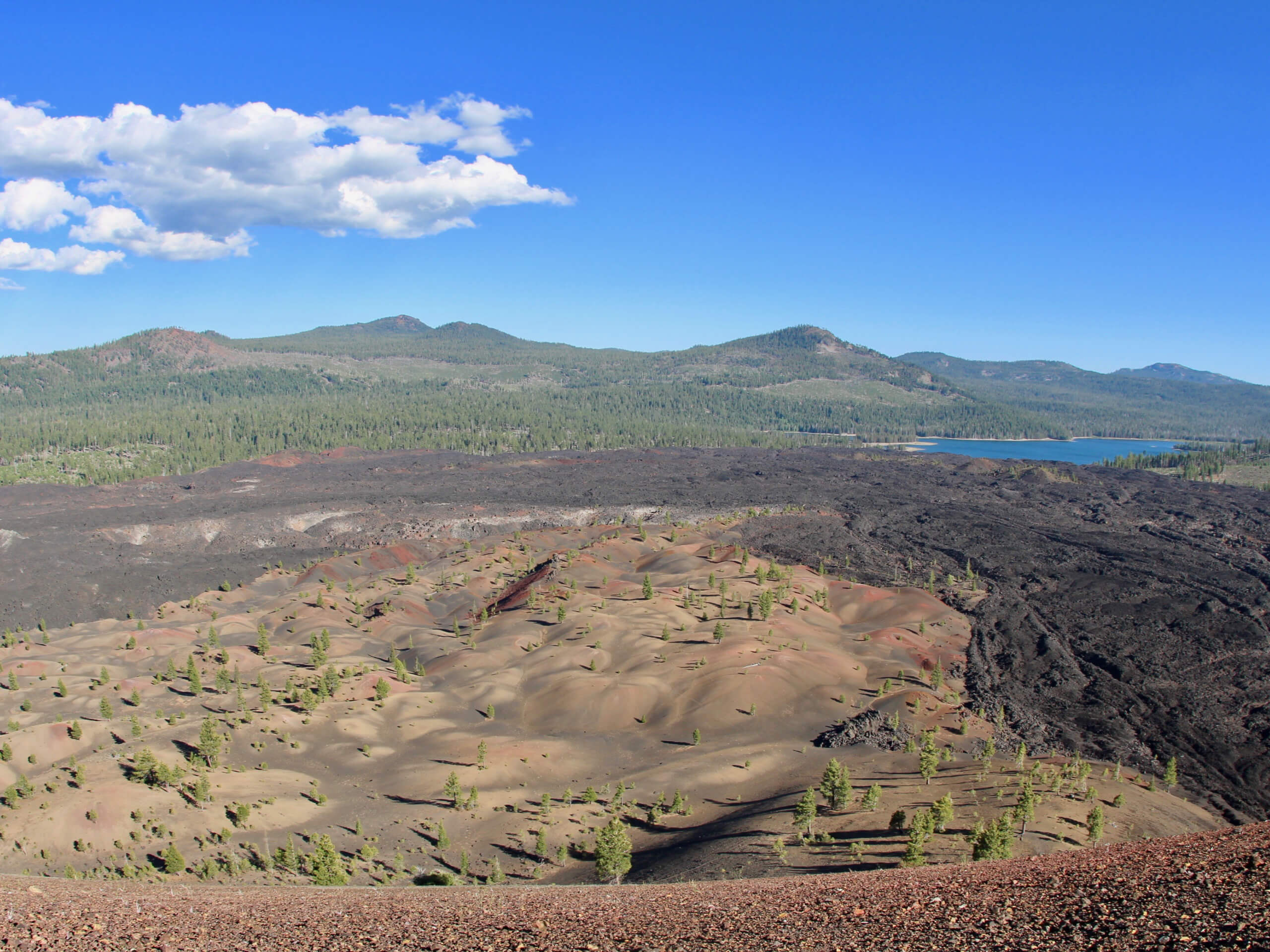
Butte Lake to Snag Lake Loop
Difficulty Rating:
The Butte Lake to Snag Lake Loop is a stunning route within Lassen Volcanic National Park. A longer route with a fair amount of elevation fluctuation, the trail is best suited for experienced hikers looking for a challenge. Taking you alongside picturesque lakes and bringing you overtop of incredible geology such as the Lassen Cinder Cone, the Butte Lake to Snag Lake Loop is an excellent choice for your next hiking adventure.
This trail was impacted by the Dixie Fire. Hike at your own risk.
Getting there
The trailhead for Butte Lake to Snag Lake Loop is located off of Butte Lake Road.

About
| Backcountry Campground | |
| When to do | May-September |
| Pets allowed | No |
| Family friendly | No |
| Route Signage | Average |
| Crowd Levels | Moderate |
| Route Type | Circuit |
Butte Lake to Snag Lake Loop
Elevation Graph
Weather
Butte Lake to Snag Lake Loop Description
Long in distance and with a notable amount of elevation fluctuation, the Butte Lake to Snag Lake Loop is a challenging route within Lassen Volcanic National Park. In addition, much of the route is along terrain that is characterized by soft volcanic sand – causing the route to feel more physically demanding then it would otherwise be. As such, the trail is likely not appropriate for those seeking a more casual hiking experience and families with children.
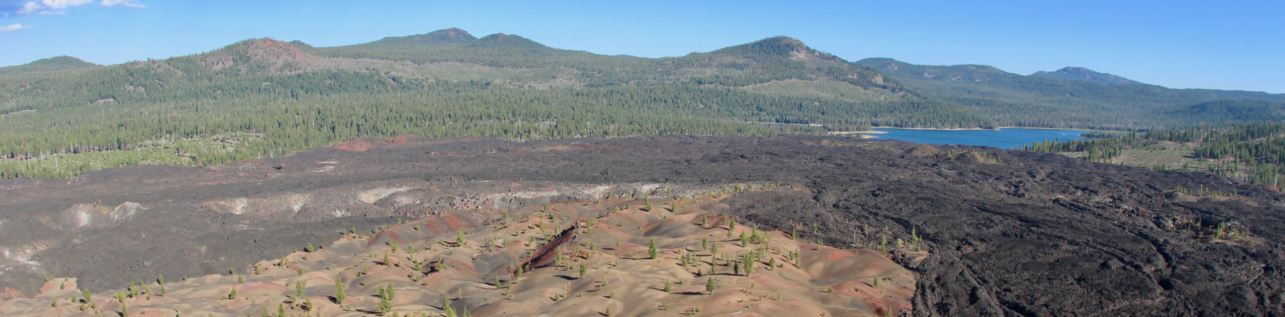
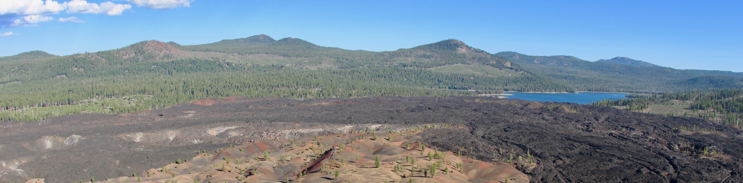
But, If you are wanting a challenging route with stunning views of a variety of terrain, then the Butte Lake to Snag Lake Loop is for you! The route leads you to the stunningly beautiful and unique geological formation of the Lassen Cinder Cone as well as along the shoreline of two picturesque lakes – all well boasting scenic views of the surrounding Lassen Volcanic National Park landscape.
Having arrived at the trailhead, follow the Butte Lake to Snag Lake Trail as it makes its way south over terrain that begins to incline almost immediately. The trail will begin to veer southwest as it approaches the Lassen Cinder Cone in the foreground. Arriving at the northern base of the Lassen Cinder Cone, you will reach a junction within the trail—take the eastern pathway onto Cinder Cone Trail. The Cinder Cone Trail is rather steep, so take your time and watch you footing. Once you’ve summited the Cinder Cone, take some time to explore before continuing on the Cinder Cone Trail down the southern side of the geological feature and meeting back up with the Butte Lake to Snag Lake Loop Trail.
Continue south along the pathway as it heads south towards Fairfield Peak in the foreground. Having reached the northern shore of Rainbow Lake, you will arrive at another junction where you’ll take the eastern pathway onto Rainbow Lake Trail. Passing by several junctions, the Rainbow Lake Trail will deliver you to the southern shore of Snag Lake, where it will meet up with the Juniper Lake to Butte Lake Trail. Take the Juniper Lake to Butte Lake Trail as it makes its way north along the eastern shoreline of Snag Lake and heads north.
Traveling over terrain that fluctuates between inclines and declines, the route will arrive at a junction at the southern shore of Butte Lake. Take the northern pathway onto Butte Lake Trail and follow it as it makes its way alongside the eastern and northern shores of Butte Lake. The trail will end at the Butte Lake Campground, where your vehicle will be waiting for you.
Trail Highlights
Cinder Cone
The Lassen Cinder Cone is a 784ft high cinder cone volcano within Lassen Volcanic National Park. In the 1650s, the Lassen Cinder Cone’s characteristic shape was established during eruptions that sent hot magma and gases surging through the earth’s crust. Debris from the eruptions fell from the sky and began to cool in a cone shape around the volcano’s vent – thereby giving the volcano its unique shape.
Insider Hints
Wear a good pair of hiking shoes - your knees and ankles will thank you!
The route can be shortened dramatically by backtracking your steps to the trailhead after Lassen Cinder Cone.
Not much shade exists throughout the route's duration. Protect yourself from the effects of the sun with sunscreen and a good hat.
The mosquitoes can be numerous in the springtime. Bug repellent is recommended!
Similar hikes to the Butte Lake to Snag Lake Loop hike
Chaos Crags Trail
Guiding you through the stunning alpine environment of Lassen Volcanic National Park, the Chaos Crags Trail is ideal for intermediate…
Terrace, Shadow, and Cliff Lakes Trail
The Terrace, Shadow, and Cliff Lakes Trail is a beautiful route within Lassen Volcanic National Park. Leading you along the…
Butte and Snag Lake to CInder Cone Loop
The Butte and Snag Lake to Cinder Cone Loop is a beautiful route within Lassen Volcanic National Park. Leading you…
Comments