Walla Crag Walk
View Photos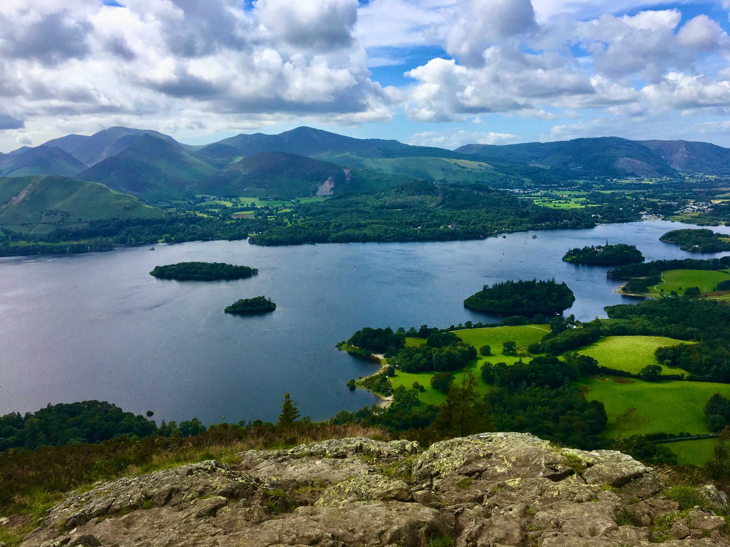
Walla Crag Walk
Difficulty Rating:
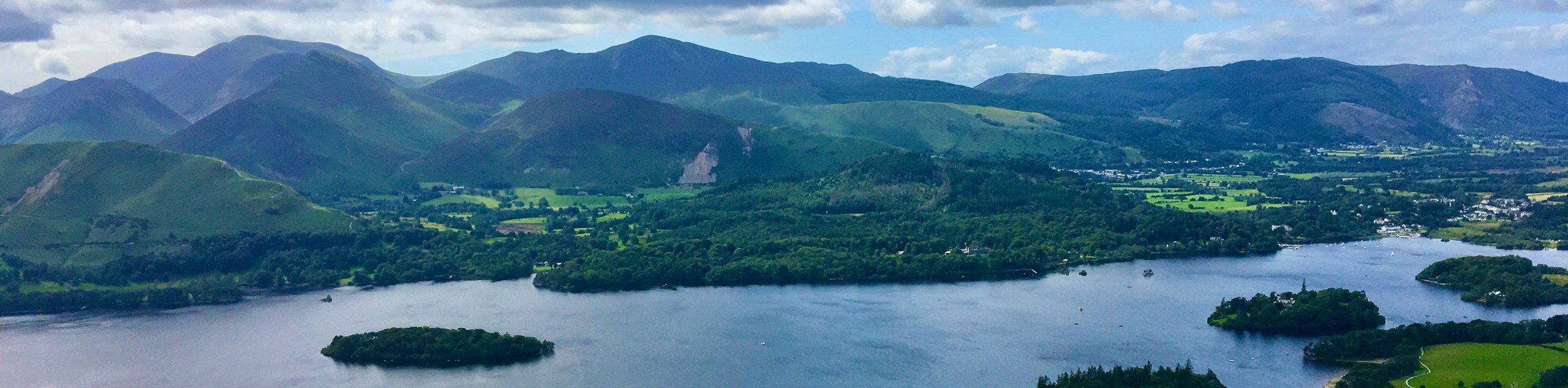
The Walla Crag Walk is a fantastic outdoor experience immediately south of Keswick that will take you to a summit vantage point atop Walla Crag. While out on the trail, you will walk along the edge of the lake and climb uphill through some steep and rugged terrain for breathtaking views overlooking the deep blue surface of Derwent Water. Portions of this walk are a bit steep, but overall the trail is an amazing experience that can be completed by casual and seasoned walkers alike.
Getting there
To reach the car park for the Walla Crag Walk from the Keswick Museum near Fitz Park, drive southwest on Station Road for 0.1mi and turn right at the first cross street onto Victoria Street. Follow this for 0.3mi and take the first exit at the roundabout onto Main Street. After 0.3mi, take the second exit at the roundabout, and you will arrive at the car park in 0.1mi.

About
| When to do | March-November |
| Backcountry Campsites | Castlerigg Farm Campsite, Castlerigg Hall Caravan & Camping Park |
| Pets allowed | Yes - On Leash |
| Family friendly | Older Children only |
| Route Signage | Average |
| Crowd Levels | High |
| Route Type | Circuit |
Walla Crag Walk
Elevation Graph
Weather
Walla Crag Walk Description
Walking the Walla Crag Trail is an amazing experience that will take you uphill for some of the best views in the Lake District, but walkers should be aware that there is some uphill climbing along relatively steep terrain to reach the summit viewpoint. Make sure to wear sturdy walking boots if you are planning to attempt this trail. Additionally, some stretches of the walk may be populated with livestock, so try to keep your dog on a lead if you are travelling through these areas.
Although the trail is fairly steep and strenuous in certain areas, the breathtaking views of the surrounding lakes and fells is a more than ample reward for the trouble. While out on the trail you will walk along the edge of Derwent Water before visiting the wonderfully scenic location of Ashness Bridge. From here, you will begin the steep climb up to the summit viewpoint, where you will experience views in every direction, including Derwent Water in the Valley below and the rugged peak of Skiddaw to the north. This is a spectacular walk that you won’t want to miss if you are in the Keswick area.
Setting out from the car park, head left along Lake Road and follow it for 0.3mi to pass by the theatre and docks, where it will transition into a walking track. From here, continue south along the trail through the wood until you arrive at the site of Friar’s Crag for an amazing viewpoint across the surface of Derwent Water. After taking in the views, continue along the edge of the water to the southeast and keep right along the trail for the next 0.2mi to pass through a gate and cross over Brockle Beck.
After another 0.3mi along the trail, you will arrive at a gated junction. Pass through the gate and keep right, turning onto the track and following it back towards the edge of the water. Follow along the wooded edge of the lake and enjoy the partial views of the forested Lord’s Island out in the middle of the water. After skirting around the edge of Calfclose Bay, you will arrive at the edge of the B5289. Cross over to the other side and pick up the trail.
Follow this path slightly uphill through the dense forest for 440ft before turning right along the road. After 0.1mi, turn left to continue uphill along a steeper grade, making sure to turn right at the next junction. From here, you will continue south along the slopes of the fell for 1.0mi to cross over several streams and reach an amazingly scenic location at the site of Ashness Bridge. Here, you will have views of a charming stone bridge in the forefront, with an amazing backdrop stretching out across the water towards Skiddaw. After taking in the views, retrace your steps for 380ft to reach a fork in the trail.
Head right here to begin the steep uphill climb across the terrain of the moor towards the summit of Walla Crag. Keep left for 0.8mi, at which point you will reach a fork in the path. Head right and keep straight for 0.3mi to arrive at the summit viewpoint. Here, you will enjoy some of the most incredible scenery that the Lake District has to offer, with Derwent Water nestled in the valley below surrounded by rugged peaks.
From the summit view point, walk along the edge of the ridge for 0.6mi to eventually arrive at a junction with a path that descends the hillside along Brockle Beck. Head left here and make your way downhill along the stream, passing through a gate and eventually crossing over the flowing water to arrive at the edge of Rakefoot Farm. Turn left and follow the lane for 0.1mi before picking up the path on the left.
Follow this path to the northwest along the edge of Springs Wood for 0.5mi, continuing to descend the hillside until you arrive at the Springs Farm Shop. Make your way onto the road here and follow it for 0.3mi, where you will find a trail branching off to the left that heads towards the summit of Castlehead. Take this path on the left and make your way through the wood, following it along the north slope of the hill for 0.3mi to arrive at the edge of the B5289.
Make your way across to the other side to complete the final leg of the Walla Crag Walk. From here, make a right at the next junction, following the path for a further 0.2mi through the open countryside to arrive back at the car park where you began. If you are looking for some post-walk refreshments, make your way to the Lakeside Cafe Restaurant, where you can refuel out on the terrace with a scenic view across Derwent Water.
Trail Highlights
Derwent Water
Located in the Borough of Allerdale, Derwent Water is one of the principal bodies of water in the Lake District and is both fed and drained by the River Derwent. Considered to be a location of considerable scenic value due to its surrounding woodlands and rugged fells, the lake is a popular tourist destination and offers access to a number of recreation activities both on and off the water.
Frequently Asked Questions
What height is Walla Crag?
Walla Crag stands at a height of 1243ft above sea level.
Insider Hints
This walk features uphill sections with some rugged terrain, making sturdy walking boots a necessity.
If you are walking with a canine companion, make sure to keep them on a leash in areas where livestock may be present.
The Lakeside Cafe Restaurant offers a great spot near the trailhead for pre/post-walk refreshments while enjoying views of Derwent Water.
The rate for parking in the Lakeside car park is £8 for up to 6 hours.

Similar hikes to the Walla Crag Walk hike

Osprey Viewpoint & Bassenthwaite Lake Walk
The Osprey Viewpoint & Bassenthwaite Lake Walk is a scenic Lake District adventure that will expose you to some beautiful…

Hawkshead, Wray Castle, and Windermere Walk
The Hawkshead, Wray Castle, and Windermere Walk is a fantastic journey that will lead you through some picturesque locations that…

Pike of Blisco and Crinkle Crags Walk
The Pike of Blisco and Crinkle Crags Trail is a challenging adventure that will see you climb several rugged peaks…
Joe M. 3 years ago
We're not experienced hikers but we really enjoyed this walk. The view from the top is beautiful. This took us a little bit longer than the stated time but we did take a wrong turn at one point. Not particularly difficult, with a couple of steep inclines.