Sheep River Falls Hike
View Photos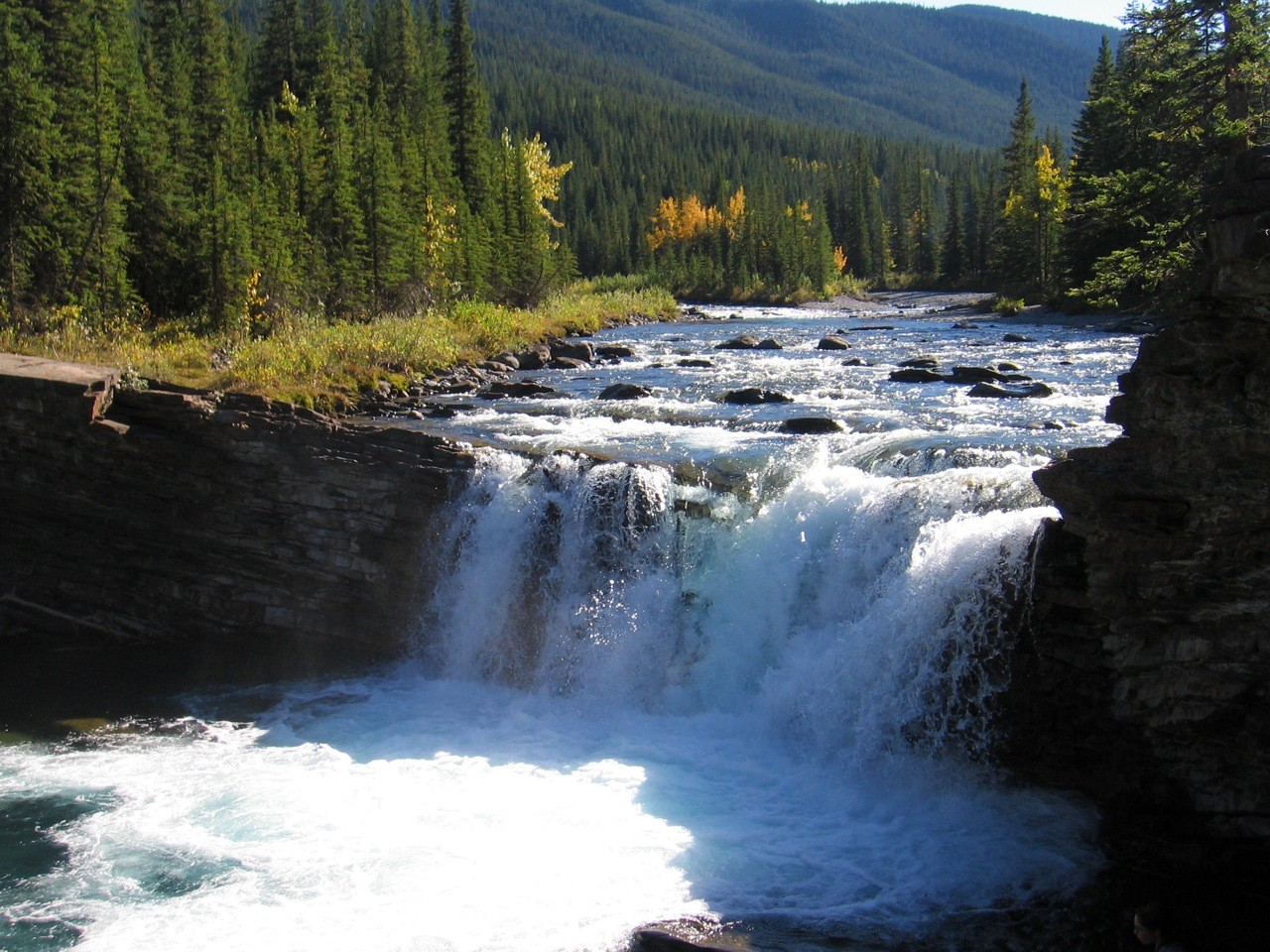
Sheep River Falls Hike
Difficulty Rating:
The Sheep River Falls trail is a short and easy trail that leads hikers to a beautiful waterfall along the Sheep River. Consider spending some time having a picnic or splashing in the water when visiting this area. You likely won’t get your heart rate up, but it is the perfect spot to enjoy some nature.
Getting there
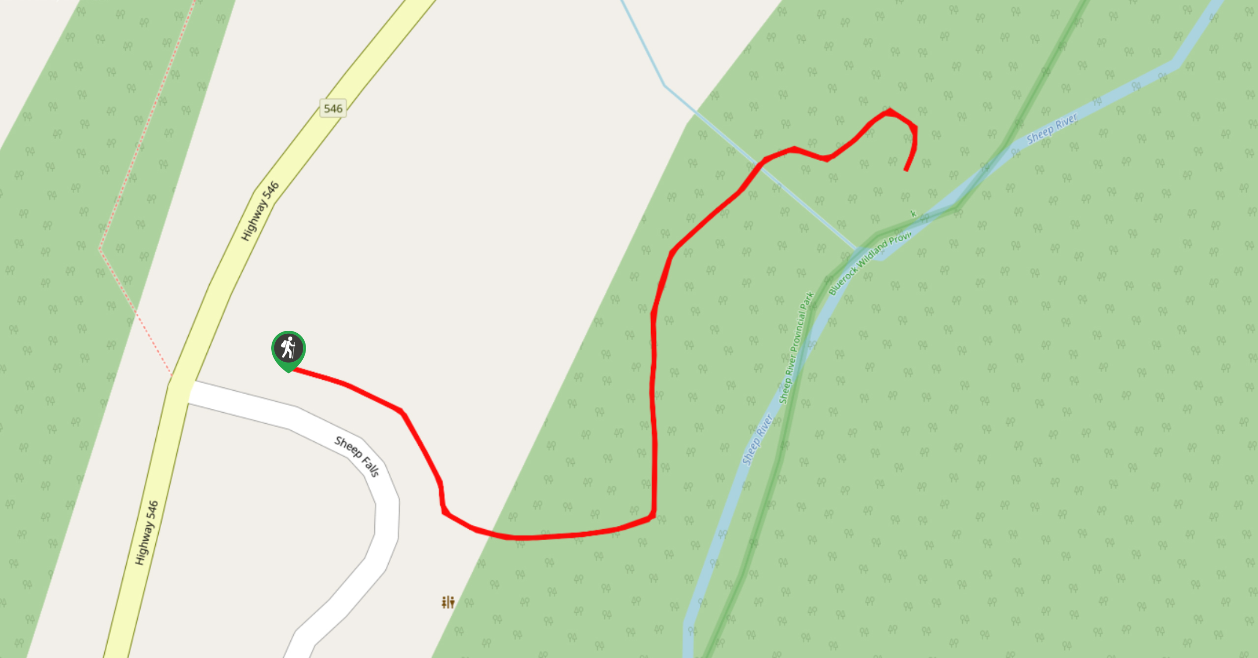
From Turner Valley, AB, take Highway 546 westbound to Sheep River Provincial Park. Travel along the highway for 22.1mi until you reach the Sheep River Falls parking and picnic area on your left.

About
| When to do | May-September |
| Backcountry Campsites | No |
| Pets allowed | Yes - On Leash |
| Family friendly | Yes |
| Route Signage | Average |
| Crowd Levels | Moderate |
| Route Type | Out and back |
Sheep River Falls Hike
Elevation Graph
Weather
Sheep River Falls Trail Description
The Sheep River Falls trail is an easy stroll with almost zero elevation gain. The falls are roughly 820ft distance from the parking area making up a 0.3mi round trip. Be prepared to take advantage of the scenic drive and picnic area before heading out on this trail. You won’t need much time to reach the falls, but this can make for a beautiful day outside if you pack accordingly.
From the parking lot, follow the clearly marked trail on the west side of the Sheep River gorge. You’ll be able to see where the foothills meet the Rocky Mountains as you approach the falls. The Sheep River runs alongside the trail showing off its crystal clear blue waters below. After 820ft, you will reach the falls, where there is plenty of space to relax on the rocks or splash in the pool below the falls. This is an incredibly accessible trail with remarkable rewards as the falls are some of the most beautiful in the area.
Take advantage of the plentiful photo opportunities here. The rocks alongside the falls create stunning slab-like steps that are perfect for posing. You’ll find small pools of water nearby that are perfect to cool down in. Pack some snacks and picnic by the falls to make this short trail worth the drive.
Trail Highlights
Sheep River Provincial Park
Explore the area of Sheep River Provincial Park while visiting Sheep River Falls. Highway 546 is a dead end road, so plan to explore the area to its full potential. The park is full of many hiking and scrambling trails along with opportunities for fishing, bird-watching, and wildlife viewing. The park is uniquely situated where the foothills meet the Rocky Mountains, which creates a diverse ecosystem for wildlife to thrive within.
Frequently Asked Questions
How Far is Sheep River Falls from Calgary?
Just over an hour’s drive from the city.
What type of fish are in the Sheep River?
Mountain whitefish and rainbow trout.
Find other amazing hikes in Kananaskis Country
- Kananaskis – Smith Dorrien Trail: Chester Lake, Tent Ridge, Burstall Pass, West Wind Pass and Rummel Lake.
- Bragg Creek and Sheep River Provincial Park: Prairie Mountain, Powderface Ridge, Nihahi Ridge and ForgetMeNot Ridge.
- Kananaskis Trail: Troll Falls, Rawson Lake, Wasootch Ridge, Sarrail Ridge and Pocaterra Ridge.
Insider Hints
Pack a full picnic and set up for a few hours near the falls to take advantage of the area
Reserve a night at nearby Bluerock Campground to make the most of a weekend in Sheep River
Make some time for another hike before you relax at Sheep River Falls. Try out the Indian Oils loop across the street or the Tunnel-O-Fun route at the end of the road.
Similar hikes to the Sheep River Falls Hike hike
Pine Woods Loop
Hiking the Pine Woods Interpretive Loop Trail doesn’t take long, but is an excellent way to find solitude in the…
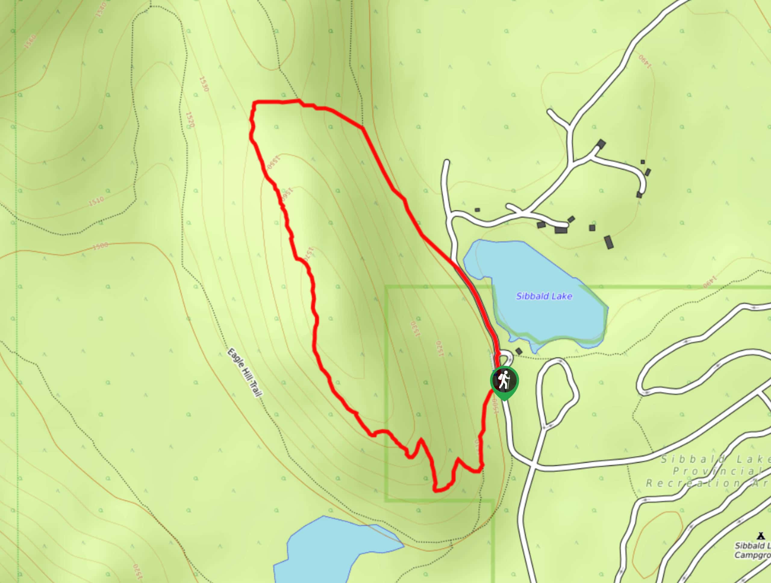
Sibbald Flats Trail
The Sibbald Flats interpretive trail travels around Sibbald Lake and includes many educational signs. It starts in the central Sibbald…
Diamond T Loop
The Diamond T Loop is an excellent beginner-intermediate trail in Kananaskis. It is part of a broader trail system and…
Comments