Shoshoni and Pawnee Peaks Hike
View Photos
Shoshoni and Pawnee Peaks Hike
Difficulty Rating:
Reserved for experienced hikers, this trail will surely get your blood pumping. The Shoshoni and Pawnee Peaks Hike will give you an adrenaline rush as you scramble to summit two craggy peaks in the Colorado Ranges. Challenge yourself by embarking on this stimulating adventure in the Indian Peaks Wilderness.
Getting there
The Shoshoni and Pawnee Peaks Hike departs from the Mitchell Lake Trailhead in the Brainard Lake Recreational Area. Parking permits are required.

About
| Backcountry Campground | |
| When to do | June-October |
| Pets allowed | Yes - On Leash |
| Family friendly | No |
| Route Signage | Average |
| Crowd Levels | Moderate |
| Route Type | Lollipop |
Shoshoni and Pawnee Peaks Hike
Elevation Graph
Weather
Shoshoni and Pawnee Peaks Hike Description
Ready for a riveting excursion up not one, but two peaks? The Shoshoni and Pawnee Peaks Hike is a difficult trail, but it will compensate its conquerors with awe-inspiring 360-degree views from the summits and the pass. Vistas of neighboring peaks and the lush alpine landscape below await! Make sure to bring plenty of water on this hike, you will quickly tire out. Bear in mind you will be ascending to extreme elevations, so be sure to bring plenty of layers and be prepared for inclement weather at the summits! Additionally, microspikes and hiking poles might come in handy as you navigate the rocky and sometimes snow dusted peaks! This hike requires experience and a bit of preparation, but we know you’ll enjoy it!
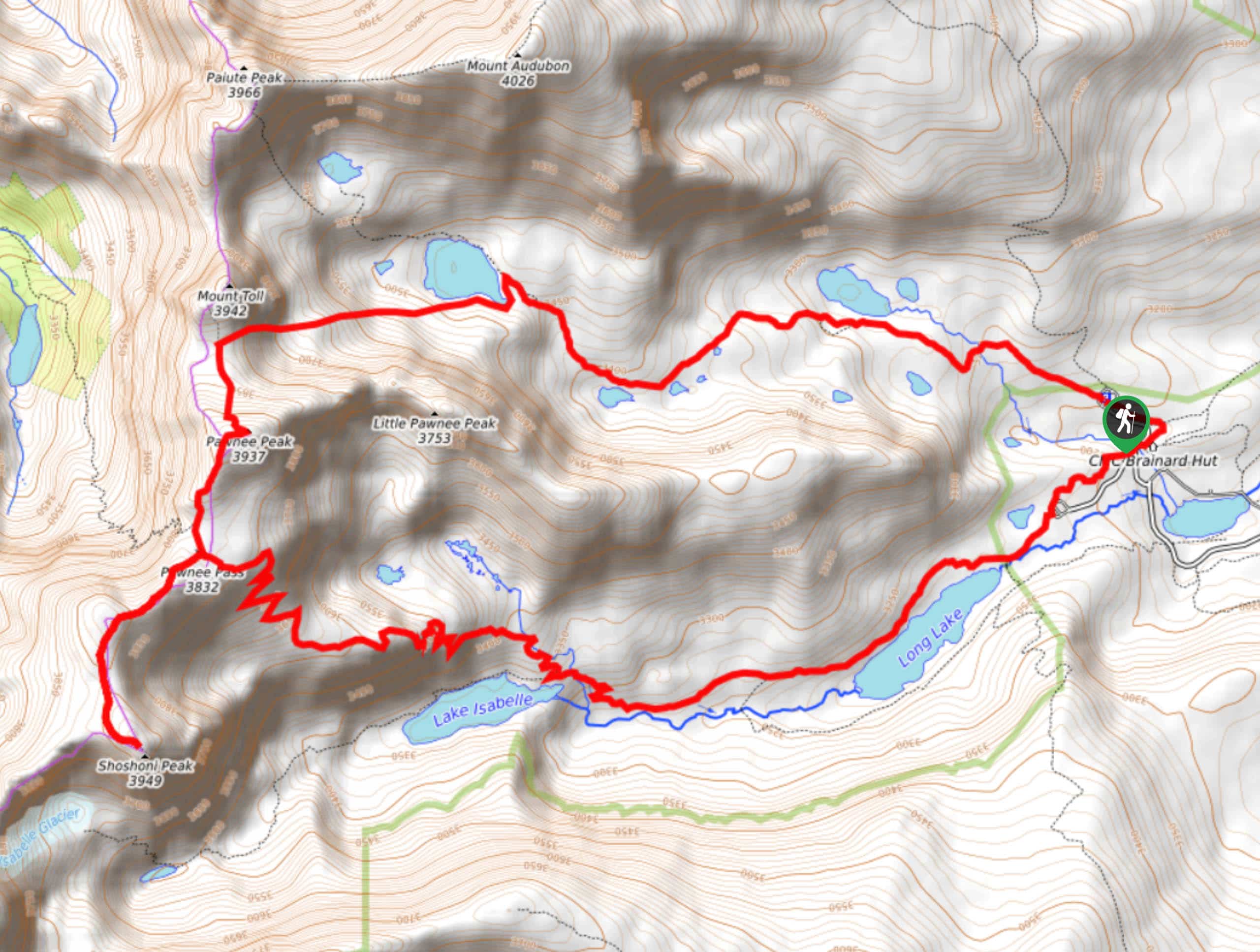
Start the Shoshoni and Pawnee Peaks Hike from the Mitchell Lake Trailhead. You can complete this trail from either direction, but we recommend doing it clockwise. From the trailhead, backtrack onto Mitchell Lake Road, merging right onto Long Lake Road. At the end of Long Lake Road get onto the Pawnee Pass Trail. Continue along the Pawnee Pass Trail, passing both Long Lake and Isabelle Lake. Veer right at the Isabelle Lake junction to follow the Pawnee Pass Trail. This section of the hike ascends the treeline and gets increasingly steep and rocky as you navigate switchbacks up to the pass. Scramble up the rocky talus, minding your footing. Once you ascend the pass, divert left and head south onto Shoshoni Summit Route. Be careful as you cross the ridge to the summit.
Enjoy the views from Shoshoni Peak before descending back down to the pass. Continue straight onto Pawnee Pass Trail, hiking through the saddle. Merge onto Pawnee Peak Trail and navigate the scree to the summit. From Pawnee Peak, head north down the trail before veering right towards Blue Lake. This trail is hard to follow but maneuver the ridge and follow cairns back down to Mitchell Lake Trail. Follow Mitchell Lake trail back below the tree line and continue hiking the path until it delivers you back to the parking lot.
Similar hikes to the Shoshoni and Pawnee Peaks Hike hike

Caribou Pass Hike
The Caribou Pass Trail scales the west side of the Continental Divide. This short but steep hike will get your…

Beaver Creek Trail
Beaver Creek Trail is a great wooded hike through the Colorado wilderness. With picturesque babbling brooks and past vast wildflower…
Beaver Reservoir to Monarch Lake Hike
Beaver Reservoir to Monarch Lake Hike is a one-way trail in the Indian Peaks Wilderness. We love this hike because…
Comments