Devil’s Thumb Pass
View Photos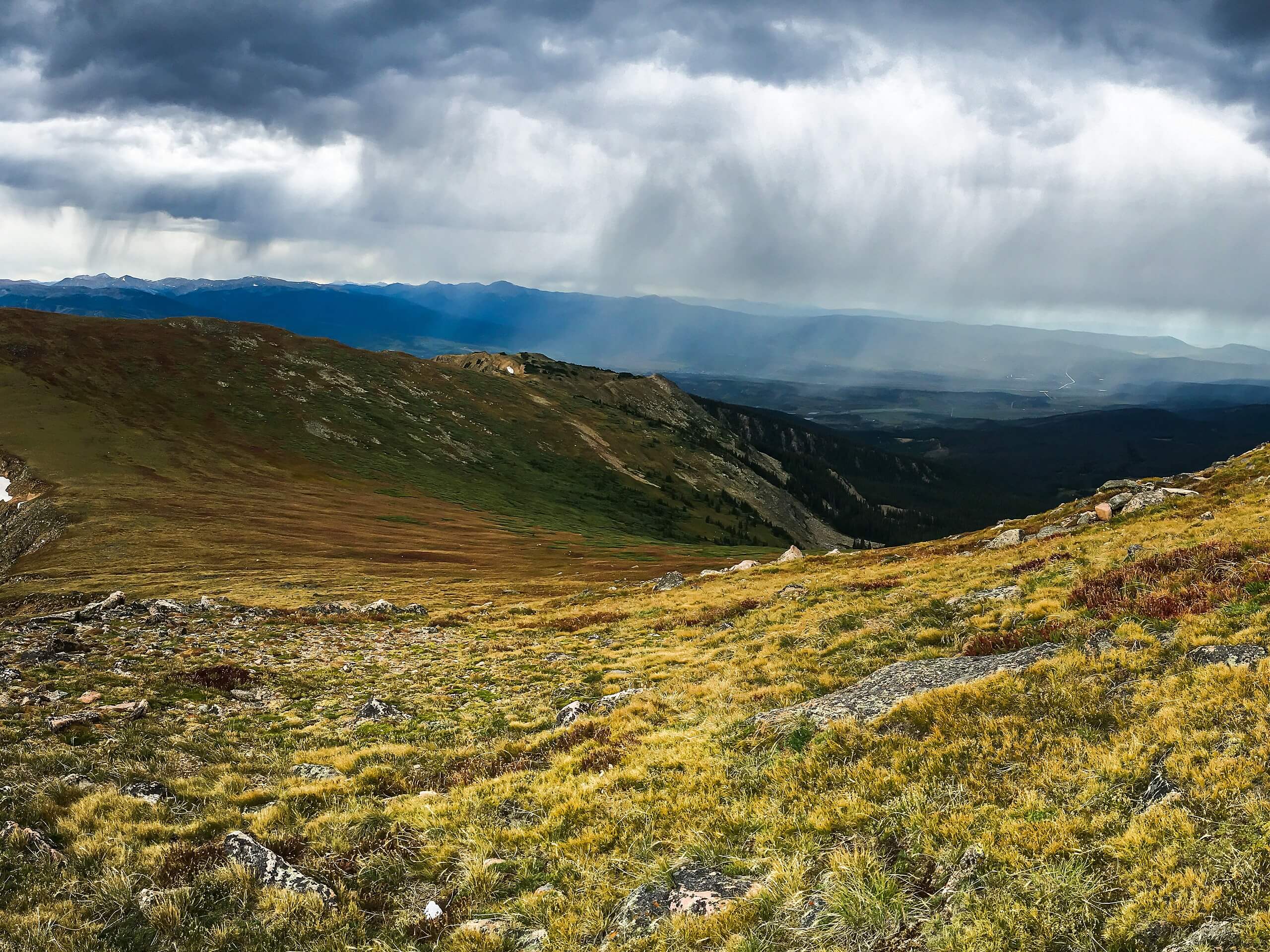
Devil’s Thumb Pass
Difficulty Rating:
Steep and scenic are two words often used to describe the Devil’s Thumb Pass hike. Reserved for experienced hikers, this trail is not for the faint of heart. A lengthy and steep ascent through pine forests and meadows rewards hikers with breathtaking views above the tree line. The Devil’s Thumb Pass is a demanding excursion that summits the Continental Divide.
Getting there
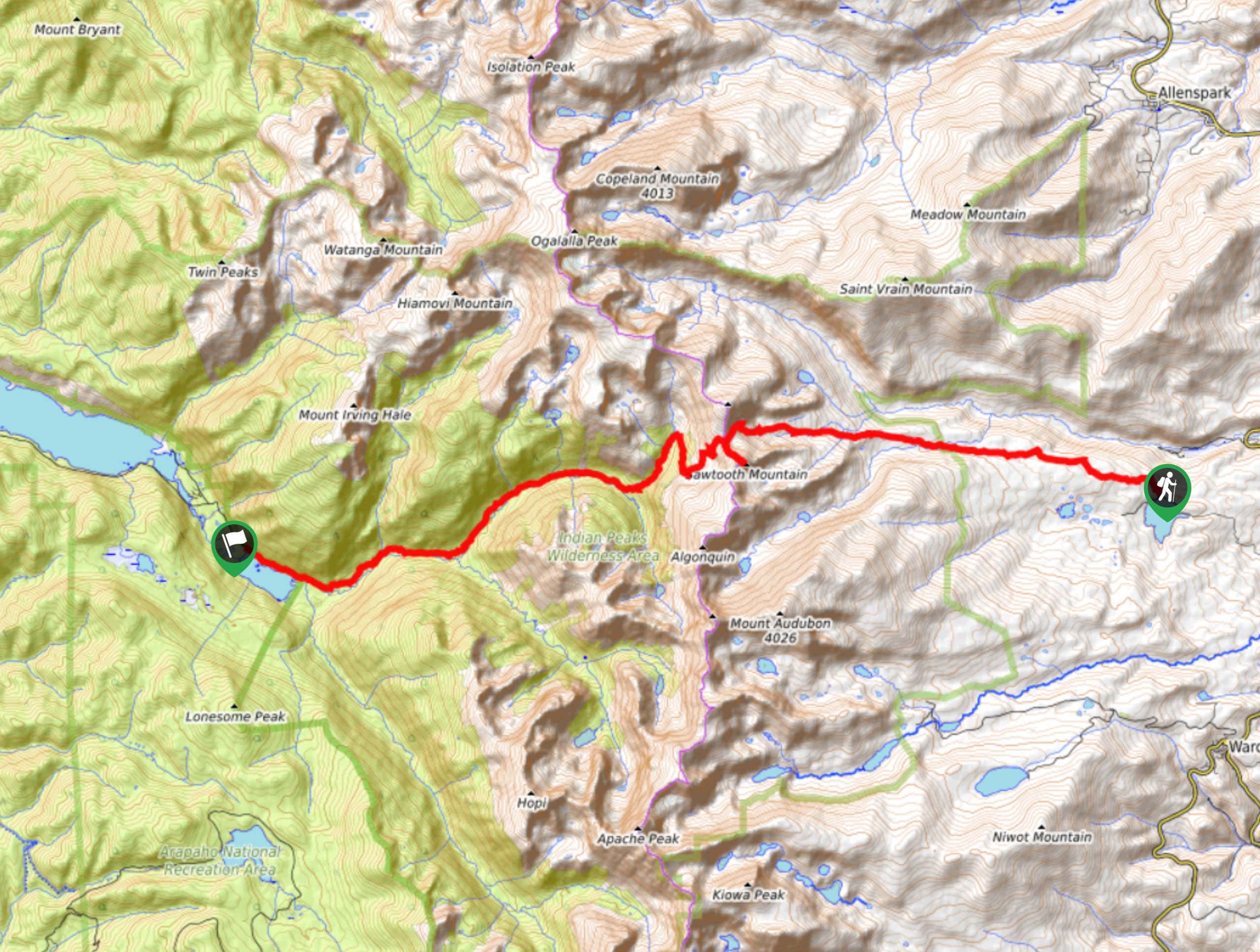
From Faser take Country Road 81 North to Forest Road 128.8C. The trailhead is on the right.

About
| Backcountry Campground | Yes, permits required. |
| When to do | June-October |
| Pets allowed | Yes - On Leash |
| Family friendly | No |
| Route Signage | Average |
| Crowd Levels | Moderate |
| Route Type | Out and back |
Devil’s Thumb Pass
Elevation Graph
Weather
Devil’s Thumb Pass Hike Description
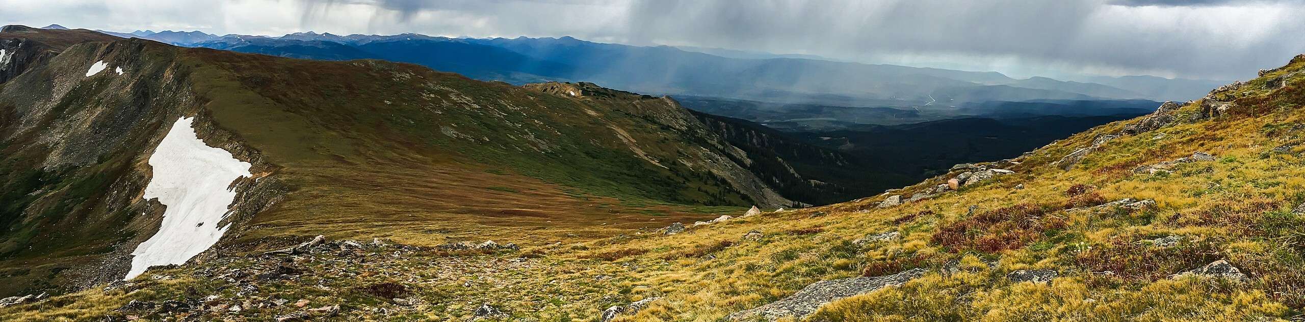
Devil’s Thumb Pass in Indian Peaks Wilderness is a challenging hike, but well worth the effort. Initially this trail might give you a false sense of its difficulty as you meander through the pine forest, but don’t be fooled, after a few kilometers the majority of the hike is uphill! Hikers will have to traverse sections of uneven and steep terrain, so be cautious—hiking poles can be useful when navigating these tricky areas of the pass. As hikers gain elevation, the trail becomes exposed, the wind and weather are often drastically different compared to the trailhead, so we recommend wearing layers! Dogs are more than welcome on this trail, but they must remain on their leash.
Devil’s Thumb Pass is a spectacular hike that provides some of the most picturesque views on the Continental Divide. This trail will surely get your blood pumping so be sure to pack some water and snacks to refuel! The top of the Pass is fairly rocky and barren, but if you adventure in the warmer months, the meadows are littered with beautiful wildflowers.
The trailhead for the Devil’s Thumb pass is in the carpark, but heads up, there are no bathroom facilities. Start your hike by heading east on the Devil’s Thumb Park Trail Connector. Continue on this route until you reach a junction. Veer right onto High Lonesome Trail. This section of the trial will begin to get steep as you begin your ascent to Devil’s Thumb. Exercise caution in this section of the trail—there are many exposed roots and loose rocks.
As you make your way along the trail be sure to keep an eye out for moose, they are often sighted in the wooded sections of the trail near Cabin Creek! Continue along High Lonesome Trail gaining elevation. Once you summit the tree line the trail will curve south for less than a kilometer before sharply redirecting you east across the pass again. Follow the trail east until you reach its boundary—this is the end of Devil’s Thumb Pass; it should be recognizable by the prominent tower of rocks on the mountain pass. Save some time to relax and explore at the top, where you can rehydrate, refuel and recognize the picturesque view!
Once the photo op is over and it’s time to head back, retrace your steps along the Lonesome Trail. Near the end of the route be sure to divert left at the junction and hook on to the Devil’s Thumb Park Trail Connector, this will guide you back to the carpark. If you are craving a longer excursion, instead of heading back, turn right at the end of Devil’s Thumb pass and continue south for approximately 0.6mi before turning left at the junction and heading east down the Devil’s Thumb Lake trail.
Insider Hints
The weather conditions vary greatly at high altitudes, so we recommend bringing microspikes in the fall season to easily navigate possible snow at the summit.
Hiking poles are always helpful, especially when hiking steep terrain, consider bringing a pair for this hike.
Similar hikes to the Devil’s Thumb Pass hike

Caribou Pass Hike
The Caribou Pass Trail scales the west side of the Continental Divide. This short but steep hike will get your…

Beaver Creek Trail
Beaver Creek Trail is a great wooded hike through the Colorado wilderness. With picturesque babbling brooks and past vast wildflower…
Beaver Reservoir to Monarch Lake Hike
Beaver Reservoir to Monarch Lake Hike is a one-way trail in the Indian Peaks Wilderness. We love this hike because…
Comments