Three Brothers Mountain Trail
View Photos
Three Brothers Mountain Trail
Difficulty Rating:
The Three Brothers Mountain Trail is a 12.7mi out-and-back route that climbs gradually through a scenic alpine meadow on the way to its namesake mountain peak. Along the trail, hikers will see amazing wildflowers within the picturesque valley before making the final ascent along the ridgeline. Here, you will experience 360° panoramic views over the mountains that straddle the Canada-United States border. If you are looking for a fairly easy hike with amazing alpine views, then the Three Brothers Mountain Trail should certainly be at the top of your list.
Getting there
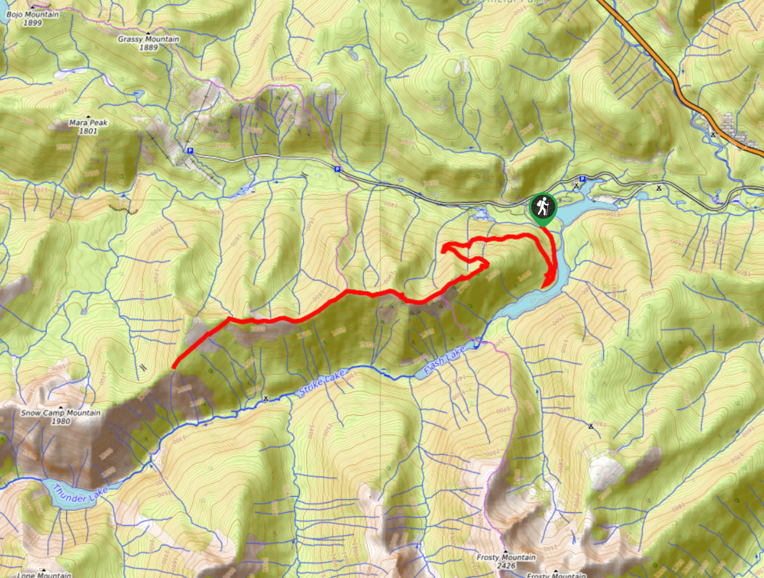
To get to the trailhead for the Three Brothers Mountain Trail from Hope, drive east on BC-3 E for 37.3mi and make a left turn onto Owl Way. From there, make another left onto Blackwell Road and follow it for 8.8mi to reach the trailhead.

About
| When to do | May-October |
| Backcountry Campsites | Buckhorn Camp Site |
| Pets allowed | Yes - On Leash |
| Family friendly | No |
| Route Signage | Average |
| Crowd Levels | Moderate |
| Route Type | Out and back |
Three Brothers Mountain Trail
Elevation Graph
Weather
Three Brothers Mountain Trail Description
The Three Brother Mountain Trail is an amazing hike in E.C. Manning Provincial Park that sets out from an elevated trailhead next to Blackwall Peak and follows along the Heather Trail to reach Three Brothers Mountain. Although the trail begins at an elevation of nearly 6562ft and climbs along a gradual incline to finish atop the mountain at 7454ft, hikers should note that this is misleading, as the cumulative elevation gain along the undulating trail is actually closer to 2953ft. Additionally, the trail does not offer much in terms of protection from the sun, so hikers should remember to bring sunscreen or cover exposed skin.
This hiking route is easily one of the most spectacular trails within E.C. Manning Provincial Park and provides a relatively easy hike to reach truly amazing views. Unlike many other alpine trails, accessing this route is extremely easy due to the well-maintained road that leads right up to the 6562ft mark where the trail begins. Here, the trail initially climbs uphill at a gradual pace through light forests before covering a stretch of trail that passes through beautiful alpine meadows. During the summer, these meadows are blanketed in wildflowers and make for a peaceful and serene experience as you hike up to the peak.
The final stretch of the trail climbs a bit more steeply along the rocky ridge to the summit, but this is manageable even for the casual hiker. Here, you can experience spectacular sweeping views of the rolling hills and mountains that make up the majestic landscape. The Three Brothers Mountain Trail is a great day hike to get out and experience the natural beauty of E.C. Manning Provincial Park.
Setting out from the trailhead at the lower parking lot on Blackwall Road, find the Heather Trail on the west side of the road and follow it north on a course through the trees. After 1.9km, you will reach a junction in the trail. Continue straight through and follow the trail as it gradually descends through the alpine forest for 2.6km, where you will arrive at the Bighorn Campground.
Shortly after the campground, the trail will begin to climb uphill once again, continuing in a northward direction through the spotty tree cover. Eventually, this cover will break, opening up into a beautifully scenic alpine meadow that offers the first real views along the hike. Continue along the trail, passing straight through a junction that splits off to the right to make your way up a ridge that offers amazing views of nearby mountain ridges, as well as the main objective of the day: Three Brothers Mountain.
From here, the trail will begin to descend along a steep section before arriving at a junction branching off to the right. Take this path to the right to leave the Heather Trail behind and set out on a course for the First Brother peak. As you make your way up to the top of the ridge, you will begin to experience the sweeping views that look out over the surrounding area. Keep heading toward the peak by traversing the ridgeline, taking care to stick to the path and avoid straying to either side of the steep slopes.
After a brief scramble to the peak, you will have amazing panoramic views of the entire area from atop the First Brother. To the south, you will have a sightline that stretches out to the snow-capped mountains of the Cascade Range in the United States, and to the north you will see the drier climate and undulating ridgelines that make up the terrain on the Canadian side of the border. Once you have taken in the spectacular views, head back down the same route to return to the lower parking lot having completed the Three Brothers Mountain Trail.
Insider Hints
Bring sunscreen as there is not much shade along the route.
The trail can be buggy at certain times of the year. Bring bug spray.
Wear proper hiking footwear, as the trail is a long gradual ascent with a steep finish.
Bring 2-3L of water per person, as streams are often dried up in summer/early autumn.
Similar hikes to the Three Brothers Mountain Trail hike
Three Falls Trail
The Three Falls Trail is an awesome 2.4mi out-and-back hiking route in E.C. Manning Provincial Park that takes…
East Skyline Trail
The East Skyline Trail is a 12.3mi out-and-back hiking route through the forests west of Lightning Lake that…
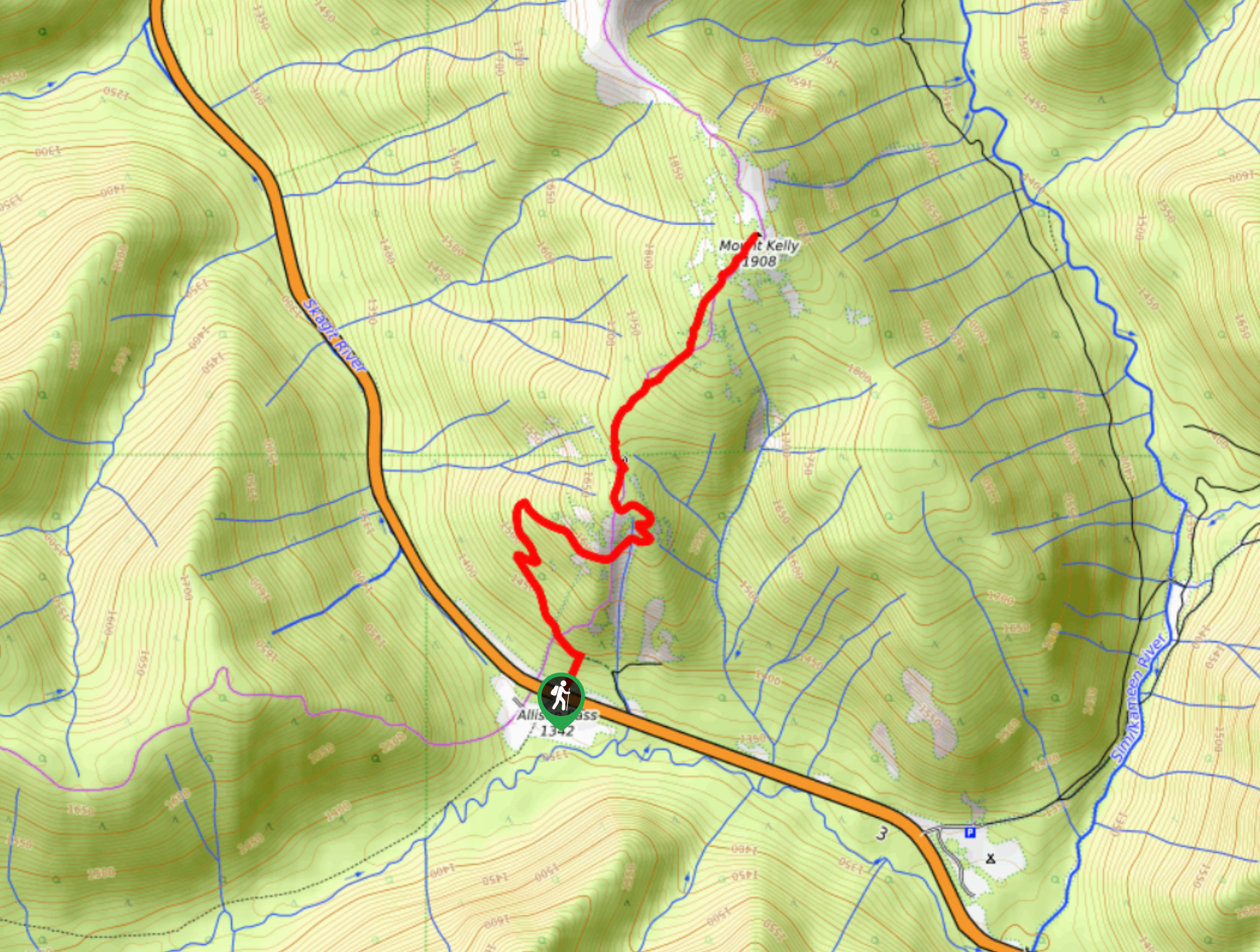
Mount Kelly Trail
The Mount Kelly Trail is a beautifully scenic 4.6mi out-and-back hiking route that climbs along the undulating ridges…
Comments