Fat Dog Trail
View Photos
Fat Dog Trail
Difficulty Rating:
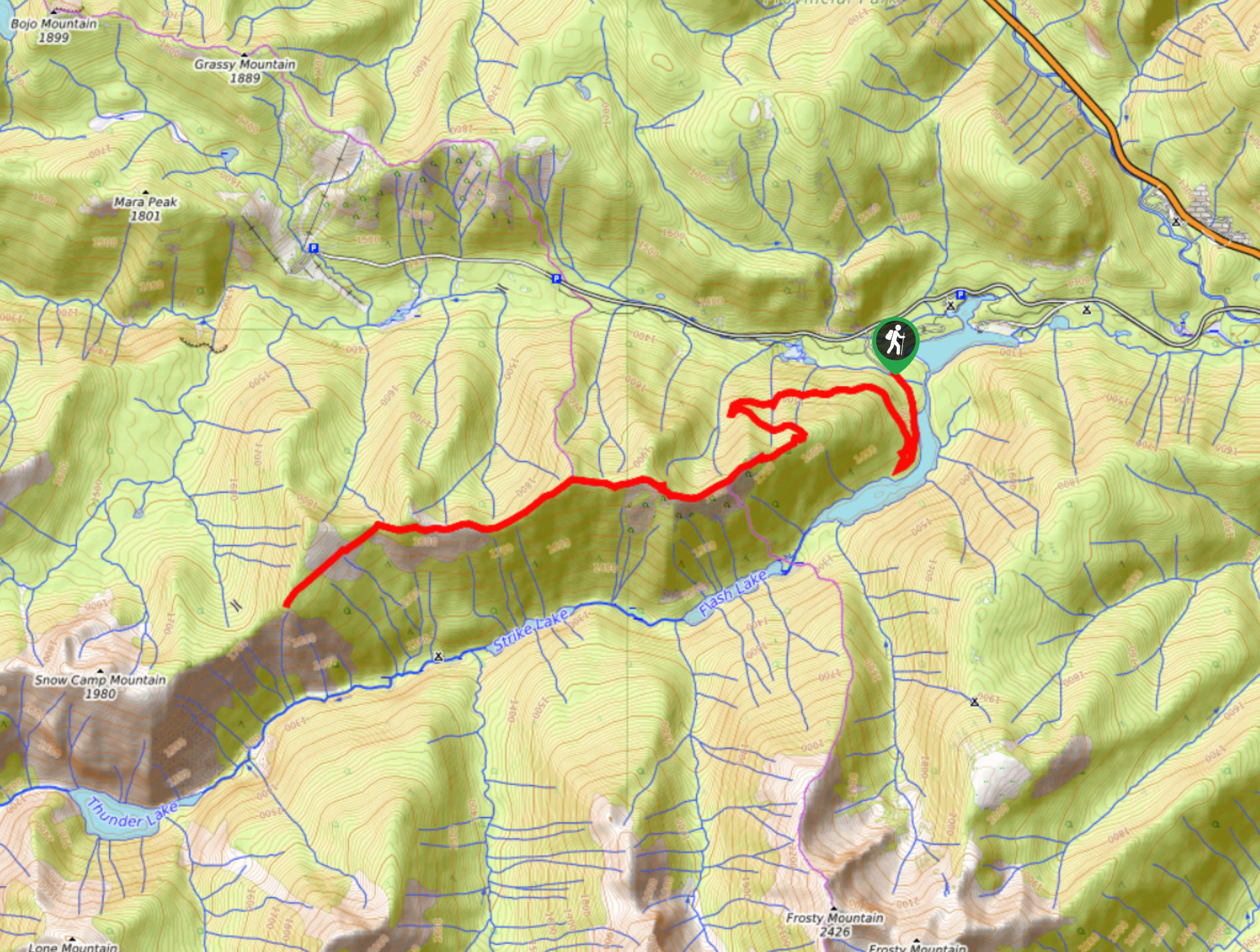
The Fat Dog Trail is a 9.2mi out-and-back route in E.C. Manning Provincial Park that is open for winter access only, operating from December-March. Because of this, the route is popular with snowshoers and cross country skiers, but can also be utilized by hikers depending on trail conditions. This amazing trail is a great option to get out into the scenic winter landscape of the park and enjoy majestic views of nearby mountains.
Getting there
To get to the parking area for the Fat Dog Trail from Hope, drive east on BC-3 E for 32.5mi and make a left turn at the Cambie Creek Campground to access the trailhead.

About
| When to do | December-March |
| Backcountry Campsites | Cambie Creek |
| Pets allowed | No |
| Family friendly | Older Children only |
| Route Signage | Poor |
| Crowd Levels | Moderate |
| Route Type | Out and back |
Fat Dog Trail
Elevation Graph
Weather
Fat Dog Trail Description
The Fat Dog Trail is a winter access only route in E.C. Manning Provincial Park that is a popular destination for hiking, cross country skiing, and snowshoeing. Due to the trail only being open in the winter months, this route is largely used for skiing and snowshoeing, but hiking with microspikes or crampons is possible depending on the amount of snow along the trail. For those travelling on foot, it is best to hike off to the side of the trail so as not to disturb any previously laid ski tracks along the route. Make sure to dress appropriately for the conditions along the trail and bring any necessary gear and supplies for the trek including plenty of water, bear spray, and appropriate footwear/hiking poles to help traverse the snowy terrain.
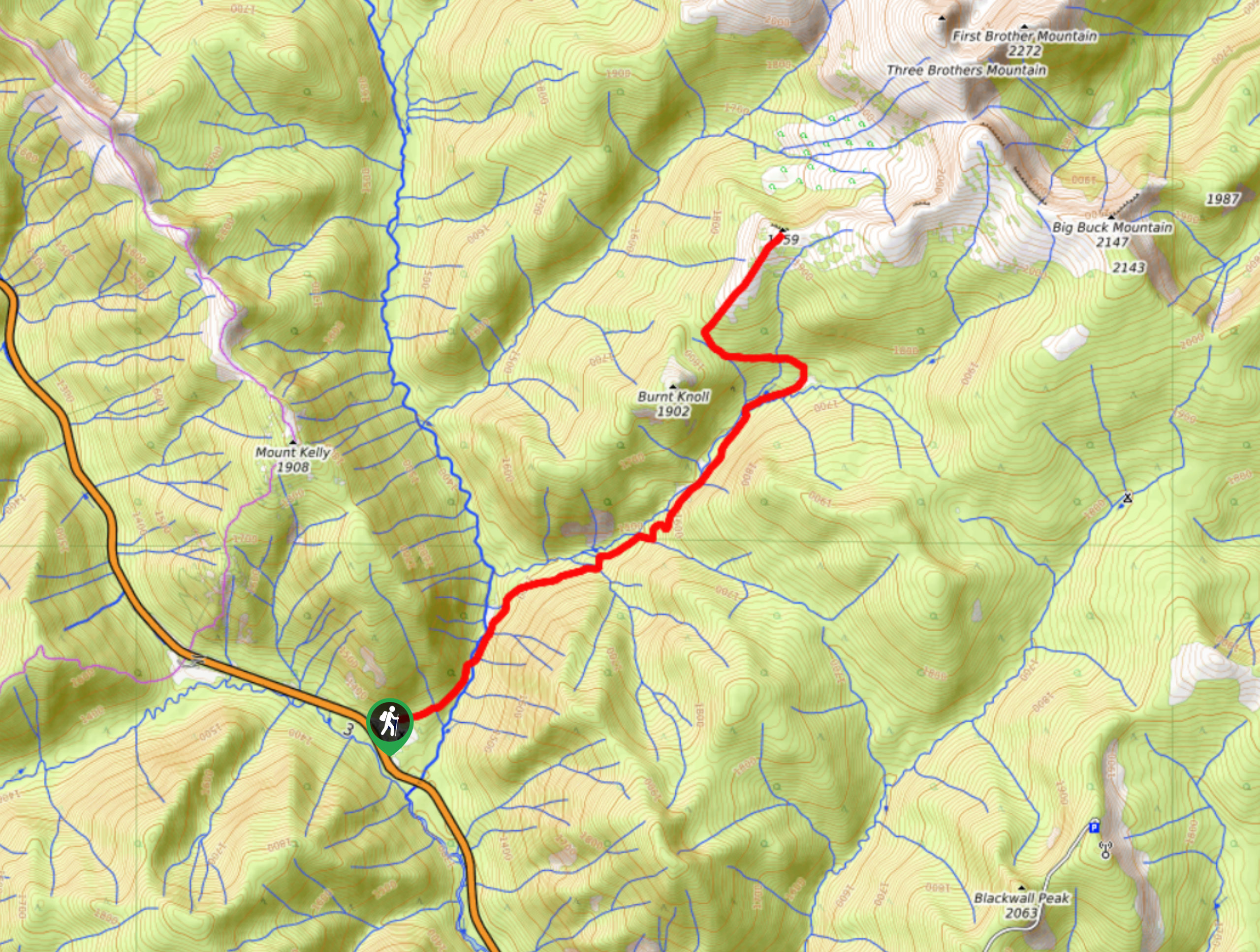
This 9.2mi trail climbs gradually uphill for an elevation gain of 2287ft, making for a fairly easy-going trek into the backcountry of E.C. Manning Provincial Park. There are no real steep or difficult to navigate sections along the trail, but it does travel along a relatively unmarked route that is easy to follow. Initial stretches of this route climb uphill through the forest for approximately 3.1mi before opening up into a scenic alpine meadow with views of the surrounding mountains. At the end of the trail, you will be able to experience an amazingly picturesque sightline over the rugged mountains including Frosty Mountain to the south, Three Brothers Mountain to the northeast, and much of the North Cascades Range. This amazing trail offers the perfect winter wonderland if you are planning a trip to E.C. Manning Provincial Park.
Setting out on the trail next to the Cambie Creek Campground, make your way past the signpost along the flat, tree-lined path. You will soon reach a fork in the trail. Follow the route to the right to cross over a creek and continue on a path that skirts alongside the rushing waters of the Similkameen River. After a few hundred metres, you will cross over a bridge spanning the river, following along with the sound of the water as it now flows to your left.
Continue along the Fat Dog Trail as you keep right at the next two trail junctions. From this point on, there will not be any more trail markers or signs; however, the route is well-travelled and easy to follow.
The next portion of the trail will climb up and down a series of hills that present the most difficult (but very manageable) parts of the route. After making your way up the long grind of the last hill, the trail will level out for a bit before gently climbing for the remainder of the hike. As you make your way up these final kilometres, you will notice that the tree cover will begin to dissipate, opening up to beautiful alpine views.
From this open viewpoint at the end of the trail, you will be able to look out over the natural beauty of the surrounding area within and beyond the park, with Three Brothers Mountain to the northeast and Frosty Mountain and the United States to the south. After breathing in the crisp mountain air and taking in the majestic views of E.C. Manning Provincial Park, make your way back down the Fat Dog Trail to return to the parking lot below.
Hiking Route Highlights
North Cascades
The North Cascades are a portion of the Cascade Mountain Range that spans a part of the Canada-United States border between British Columbia and Washington State. This area is known for its difficult mountaineering and rugged terrain, but also for its scenic alpine meadows that provide relief to the otherwise dramatic landscape.
Insider Hints
This trail is a popular route for hiking, snowshoeing, and cross country skiing. If travelling on foot, stay off to the side to avoid disturbing the ski tracks.
Bring plenty of water and snacks, as hiking through the snow can be physically demanding.
Bring bear spray to avoid any dangerous encounters.
Similar hikes to the Fat Dog Trail hike
Three Falls Trail
The Three Falls Trail is an awesome 2.4mi out-and-back hiking route in E.C. Manning Provincial Park that takes…
East Skyline Trail
The East Skyline Trail is a 12.3mi out-and-back hiking route through the forests west of Lightning Lake that…
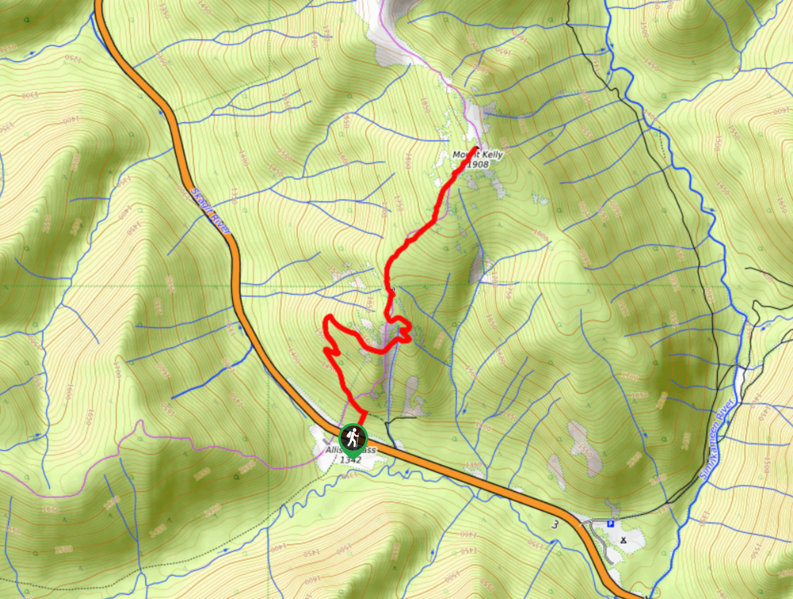
Mount Kelly Trail
The Mount Kelly Trail is a beautifully scenic 4.6mi out-and-back hiking route that climbs along the undulating ridges…
Comments