
Woodbury Common Loop
View Photos
Woodbury Common Loop
Difficulty Rating:
The Woodbury Common Loop is a great adventure in Devon that will take you across a variety of terrain to view the picturesque countryside. Along the trail, you will make your way along rolling hills, charming lakes, and through serene stretches of forest; all of which make for a relaxing day on the trails. This is a multi-use trail that is often populated with mountain bikers, so be sure to keep an eye out and share the trail.
Getting there
To reach the trailhead for the Woodbury Common Loop from Woodbury, drive southeast on Broadway/B3179 for 1.5mi and continue straight through the junction. In 145ft, turn right to enter the car park.

About
| When to do | Year-Round |
| Backcountry Campsites | No |
| Pets allowed | Yes - On Leash |
| Family friendly | Yes |
| Route Signage | Average |
| Crowd Levels | Moderate |
| Route Type | Circuit |
Woodbury Common Loop
Elevation Graph
Weather
Woodbury Common Loop Description
While the Woodbury Common Loop isn’t an overly difficult or technical route, there is a high density of trails in the area that can make navigation a challenge. To avoid straying off course, try bringing a GPS or trail map to help you find your way. Additionally, there is a good chance that you will encounter other outdoor enthusiasts, such as bikers and trail runners on your adventure, so remain aware and leave enough room for others to pass.
Even with the above mentioned difficulties in navigation, this is an awesome walking route that will take you through the beautiful landscapes found within the Woodbury Common and wider Devon countryside. While out on the trail, you will navigate open fields, rugged moors, and charming forests that will provide you with some wonderful views of the surrounding area. Paths here are also well-maintained and the terrain is easy to traverse, making for a great day on the trails that can be enjoyed by all.
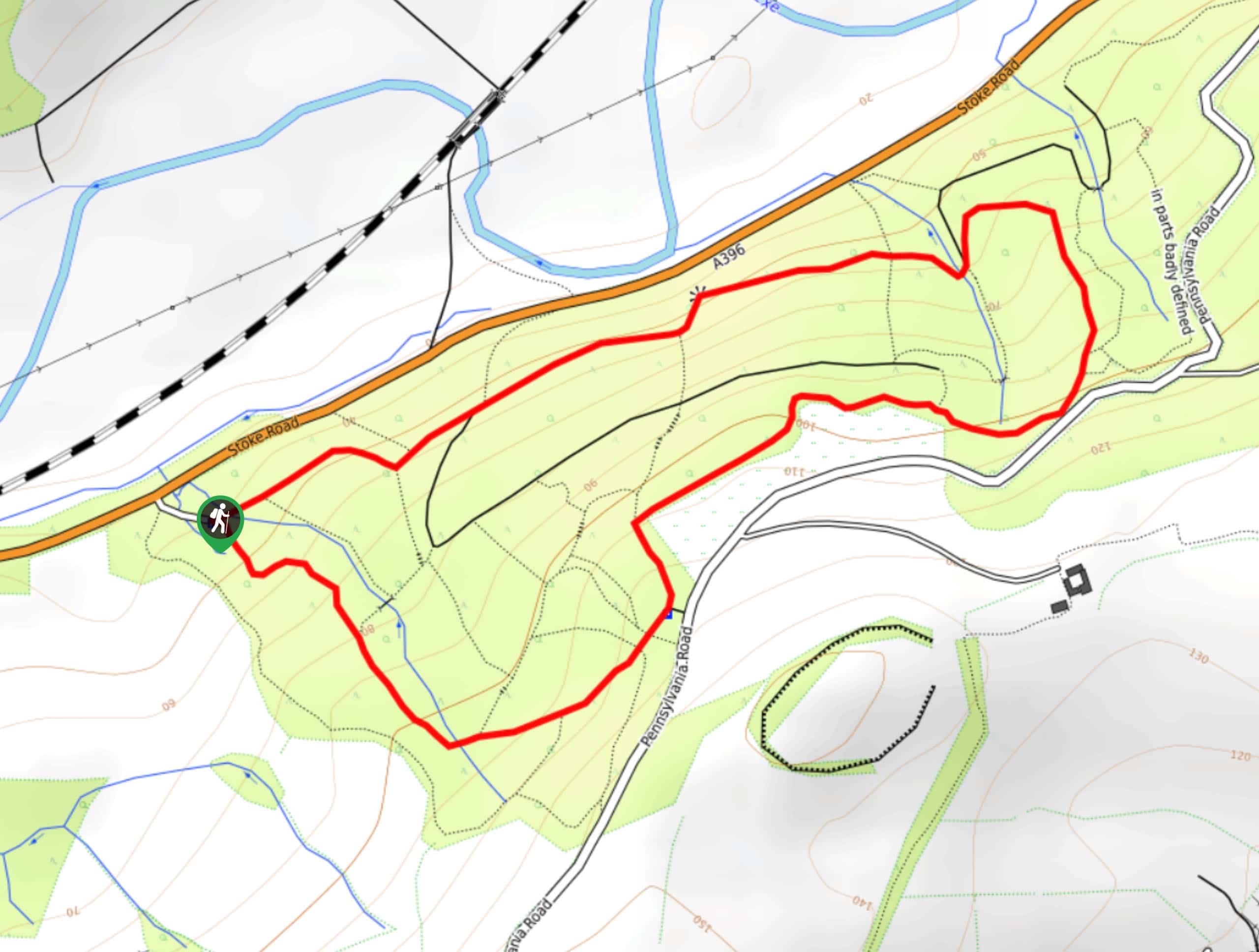
Setting out from the car park, make your way southeast past the information sign and turn right at the next junction. Continue south for the next 0.9mi to traverse the undulating landscape and pass through a brief stretch of woodland terrain, skirting around several scenic lakes within a quarry, before arriving at the edge of a road. From here, cross over to the opposite side and continue south through the car park, picking up the trail in the southwest corner. Head left at the next junction and make your way to the southeast across the lightly forested terrain, picking up a trail on your right in 0.1mi.
At the next junction, turn left and follow the path in an eastward direction to cross over another road. Here, you will make your way through another car park and continue on to the southeast, following the trail for 0.4mi to arrive at a fork. Take the path on the right and keep left for the next 0.3mi, working through the wonderfully atmospheric forest terrain of Hayes Wood to arrive at another junction. Take the path on the left and follow it north across the undulating landscape for 0.5mi, where you will meet up with the edge of Hayes Lane. Turn right here and follow the lane for a few feet, before picking up the footpath on the opposite side of the road that will take you past a small reservoir and several buildings.
Continue to the north along the path for 0.4mi and turn right along the lane to cross over Budleigh Brook and meet up with the road outside of the village of Yettington. Turn left and follow the road for 0.3mi, where you will pick up a footpath on the right. This part of the route will likely be the most confusing, as there are a number of intersecting pathways along the trail that can make navigation tricky. Keep an eye on your GPS or trail map, as you work your way to the northwest for the next 1.2mi, passing through the stretches of tranquil forest and rugged moorland terrain that make up Woodbury Common. Eventually, you will arrive at a four-way junction. Take the path on the left that leads south and cross over the road to arrive back at the car park where you began your adventure along the Woodbury Common Loop.
Insider Hints
Wear comfortable walking shoes to better traverse the variety of terrain along this route.
There are a number of intersecting paths in the area, so bring a GPS or trail map to aid in navigation.
There may be other people mountain biking in the area, so keep an eye on children and keep your dogs on a lead.
If the car park at the trailhead is full, try driving a 0.4mi further along the road to the Model Airfield car park.
Similar hikes to the Woodbury Common Loop hike
Stoke Woods Circular Walk
The Stoke Woods Circular Walk is a quick and fairly easy adventure near Exeter that will expose you to some…
Ottery Saint Mary Woodland Walk
The Ottery Saint Mary Woodland Walk is a great excursion in Devon that features some relatively easy to manage terrain…

Exe Valley Way
The Exe Valley Way is a long distance walking route in Devon that will expose you to the picturesque countryside.…
Comments