
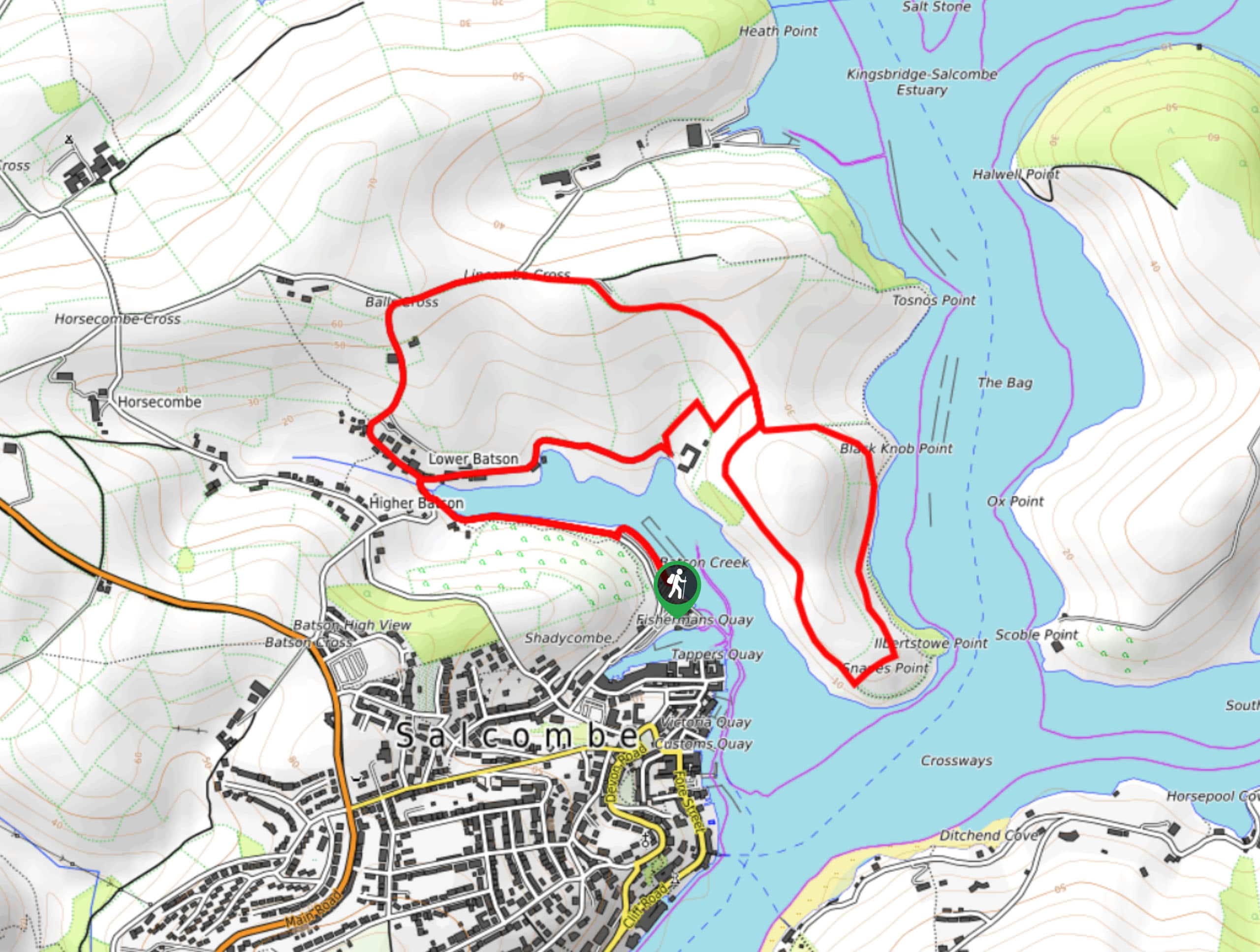
Snapes Point Walk
View Photos
Snapes Point Walk
Difficulty Rating:
The Snapes Point Walk is a fantastic walking route in Devon that will take you slightly uphill for some nice views overlooking the water. While out on the trail, you will traverse the scenic landscape of Snapes Point, taking in the stunning views that overlook Salcombe, Batson Creek, and the harbour. Easy-to-navigate terrain along this route makes it a great option for all ages and skill levels.
Getting there
To reach the trailhead for the Snapes Point Walk from Marlborough, drive east along Salcombe Road/A381 for 1.5mi and turn left at Main Road. DFollow this for 0.3mi and turn right, continuing on for 0.4mi to find the car park on the right.

About
| Backcountry Campground | No |
| When to do | Year-Round |
| Pets allowed | Yes - On Leash |
| Family friendly | Yes |
| Route Signage | Average |
| Crowd Levels | Moderate |
| Route Type | Lollipop |
Snapes Point Walk
Elevation Graph
Weather
Snapes Point Trail Description
The Snapes Point Walk is a popular trail in the Salcombe area, as it produces some lovely views along the Devon coast without exposing you to any challenging or technical terrain. Setting out from the car park, you will make your way to the northwest along the edge of Batson Creek, keeping right along the edge of the water to climb slightly uphill. After traversing Snapes Point and taking in the stunning views over Salcombe and the harbour, you will continue around the loop and climb further uphill to the northwest before descending into Lower Batson village on the return to the trailhead.
Similar hikes to the Snapes Point Walk hike
Stoke Woods Circular Walk
The Stoke Woods Circular Walk is a quick and fairly easy adventure near Exeter that will expose you to some…
Ottery Saint Mary Woodland Walk
The Ottery Saint Mary Woodland Walk is a great excursion in Devon that features some relatively easy to manage terrain…

Exe Valley Way
The Exe Valley Way is a long distance walking route in Devon that will expose you to the picturesque countryside.…
Comments