Baggy Point Walk
View Photos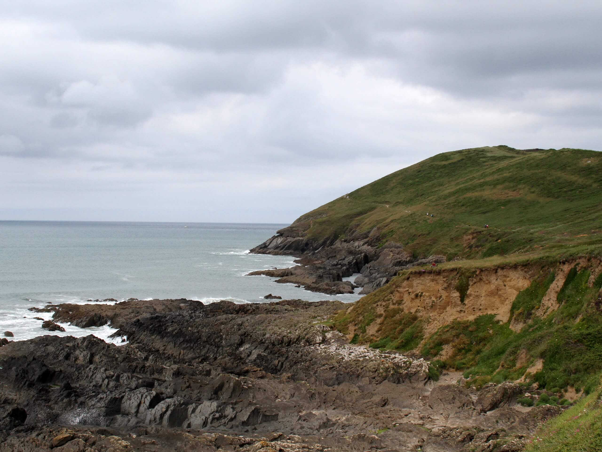
Baggy Point Walk
Difficulty Rating:
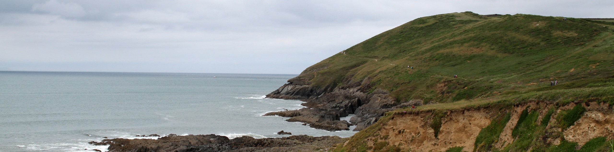
The Baggy Point Walk is a great route for anyone that loves taking in wonderful views of the ocean or visiting historical sites. While out on this relaxing walk, you will make your way along the edge of a scenic cliff that overlooks the blue expanse of the Bristol Channel before looping back along the coast to pass by several bunkers from the Second World War. The terrain here is fairly easy to navigate, making this route perfect for walkers of every skill level.
Getting there
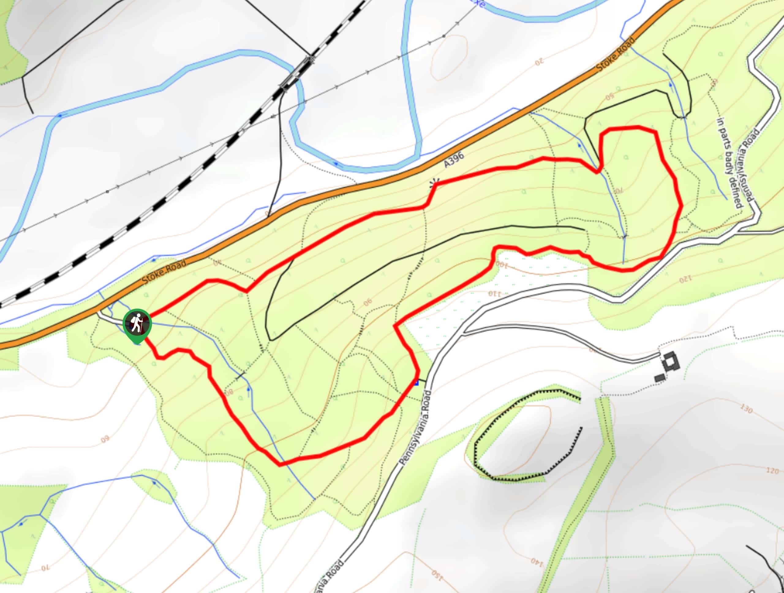
To reach the trailhead for the Baggy Point Walk from the nearby village of Croyde, drive northwest on Jones’s Hill for 0.1mi and turn left onto Moor Lane. Follow this for 0.8mi and turn right to enter the car park.

About
| When to do | Year-Round |
| Backcountry Campsites | Freshwell Camping, Ocean Pitch Campsite |
| Pets allowed | Yes - On Leash |
| Family friendly | Yes |
| Route Signage | Average |
| Crowd Levels | Moderate |
| Route Type | Lollipop |
Baggy Point Walk
Elevation Graph
Weather
Baggy Point Walk Description
There really aren’t any negatives to spending a day out walking around Baggy Point, unless you happen to catch it on a very windy day. Be sure to bring an extra layer or wind jacket to protect yourself from the strong gusts along the coast. Additionally, you should wear good walking boots or wellies after a period of rainfall, as the trail might be a bit muddy. Other than that, this is a pleasant stroll along the Devon Coast that is accessible for just about anyone that wants to experience the beautiful views across the Bristol Channel.
Setting out from the car park, you will make your way to the northwest along the road past the Baggy Surf Lodge, turning left at the fork onto Moor Lane. From here, continue along the lane for 0.12mi and pick up the path on the left to continue along the edge of the cliff. Keep left for another 0.2mi to arrive at a junction, taking the path on the right to climb slightly uphill for some excellent views across the water. Continue to the northwest and keep right for 0.6mi to pass by the ruins of a bunker from World War Two on your right. This area was used to train troops for the Normandy landings, so several wartime buildings can still be spotted in the area.
Reaching a fork in the path just after the bunker, turn left and follow the trail along the edge of the cliff, as it takes you further to the northwest to the headland known as Baggy Point. Take some time to appreciate the stunning views of the water and coastal landscape, before turning to the southeast along a lower trail that runs parallel to the water on your right. Follow this for the next 1.0mi, keeping right as you enjoy some final views overlooking the rocky shoreline and vast body of water before you, on the return to the car park where you began the Baggy Point Walk.
Trail Highlights
Baggy Point
Donated to the National Trust in 1939 by Constance and Florence Hyde, Baggy Point is a headland in Devon that divides Croyde Bay and Morte Bay. The area was used during World War Two to train American soldiers for the Normandy beach landings and is now a part of the Saunton to Baggy Point Coast Site of Special Scientific Interest (SSSI).
Frequently Asked Questions
What year was Baggy Point donated to the National Trust?
In 1939, the Hyde family donated the area known as Baggy Point to the National Trust
Insider Hints
Parking at the trailhead is £7 per day and £1 per hour after 5pm.
The trail can be fairly muddy after periods of rainfall. Bring your wellies in these conditions.
Bring an extra layer or wind jacket, as this part of the coast is exposed to the elements.
Similar hikes to the Baggy Point Walk hike
Stoke Woods Circular Walk
The Stoke Woods Circular Walk is a quick and fairly easy adventure near Exeter that will expose you to some…
Ottery Saint Mary Woodland Walk
The Ottery Saint Mary Woodland Walk is a great excursion in Devon that features some relatively easy to manage terrain…

Exe Valley Way
The Exe Valley Way is a long distance walking route in Devon that will expose you to the picturesque countryside.…
Comments