
Rawhide and Wrangler’s Run Trail
View Photos
Rawhide and Wrangler’s Run Trail
Difficulty Rating:
The Rawhide and Wrangler’s Run Trail is a popular excursion in the White Ranch Open Space Park that attracts outdoor enthusiasts of all sorts. This wonderful hike guides adventurers beneath the tree coverage of towering pines and through grassy meadows that boast views of the Front Range snow-dusted peaks.
Getting there
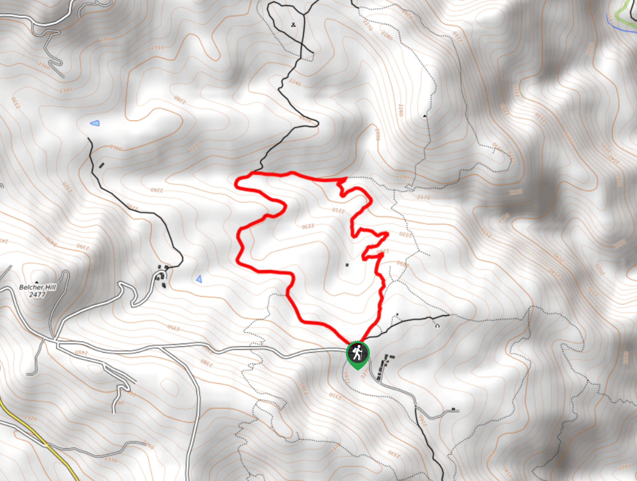
The Rawhide and Wrangler’s Run Trail is accessed via the trailhead off Belcher Hill Road.

About
| Backcountry Campground | No |
| When to do | Year-round |
| Pets allowed | Yes - On Leash |
| Family friendly | Yes |
| Route Signage | Poor |
| Crowd Levels | Extreme |
| Route Type | Circuit |
Rawhide and Wrangler’s Run Trail
Elevation Graph
Weather
Rawhide and Wrangler’s Run Trail Description
The Rawhide and Wrangler’s Run Trail is a popular excursion that exposes the diversity of the Colorado wilderness. This wonderful hike is conveniently located near Denver’s city center, making it the perfect spontaneous escape out of the ruckus. Ideal for bikers and hikers, there are always plenty of like-minded adventurers on the trail to socialize with. If you are seeking a more secluded excursion, then we would recommend an early morning weekday hike when the crowds are thinner. Note that rattlesnakes have been spotted in the area, so in the summer be mindful of them! Sections of this hike are also poorly marked, so we recommend bringing along the trail GPS as insurance.
Embark on your trek along the Rawhide and Wrangler’s Run Trail from the trailhead off Belcher Hill Road. This circuit trail can be completed from either direction, but we suggest hiking clockwise. From the trailhead, veer left and walk along the Wrangler’s Run Trail. The path will gradually descend as you travel further into the wilderness and through a luxuriant meadow. As you hike through the meadowlands keep an eye out for grazing deer and notice sights of the snow-capped Front Range peaks in the distance. The route will eventually guide you beneath the sparse pine tree coverage before curving east. Continue hiking the Wrangler’s Run Trail until you meet a junction.
At the intersection, veer right and you will be diverted onto the Rawhide Trail. Be mindful of bikers passing by as you trek! From the junction, the path will begin to slowly climb through the woodlands. As you begin to near the adventure’s end, you will have to navigate a few sets of switchbacks. Maneuver the winding terrain, and the path will lead you into the meadowlands. Follow the Rawhide Trail back to the trailhead.
Similar hikes to the Rawhide and Wrangler’s Run Trail hike
Hidden Fawn Loop Trail
The Hidden Fawn Loop Trail is a lovely meadowland adventure in the Alderfer/Three Sisters Open Space Park. Enjoy sights of…
Green Mountain Loop Hike
The Green Mountain Loop Hike is a charming nature walk along the base of Green Mountain. Hike through the grassy…
Rocky Mountain Lake Park Loop
The Rocky Mountain Lake Park Loop will transport you from the city’s center to a lakeside oasis. Hike around the…
Comments