
Maxwell Falls Lower Trail
View Photos
Maxwell Falls Lower Trail
Difficulty Rating:
The Maxwell Falls Lower Trail is one of the most popular day hikes near Denver, Colorado. Immerse yourself in nature as you trek through ponderosa pines, past granite outcroppings and up to the mesmerizing cascades. There is no doubt as to why this hike is a crowd-favorite, the stunning scenery and easy terrain attracts outdoor enthusiasts of all skill-levels. On your next trip to Denver, the Maxwell Falls Trail is a must add to your itinerary.
Getting there
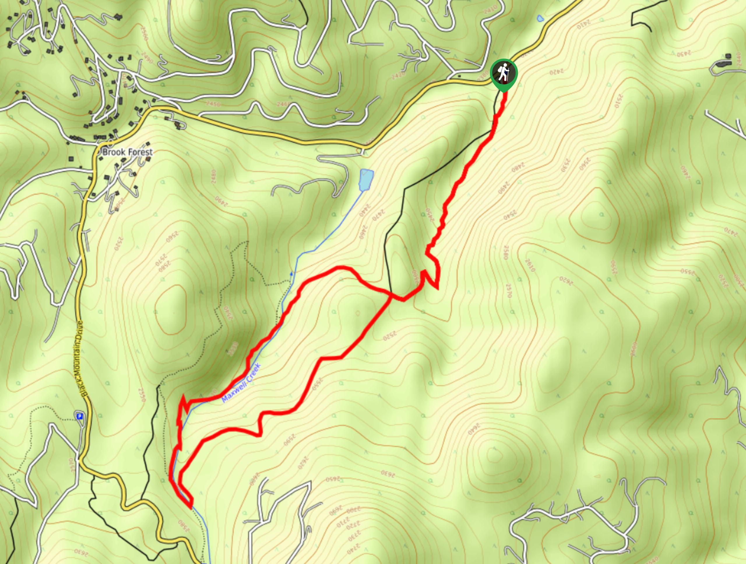
The Maxwell Falls Lower Trail departs from the lower trailhead off S Brook Forest Road.

About
| Backcountry Campground | No |
| When to do | Year-round |
| Pets allowed | Yes - On Leash |
| Family friendly | Yes |
| Route Signage | Good |
| Crowd Levels | High |
| Route Type | Lollipop |
Maxwell Falls Lower Trail
Elevation Graph
Weather
Maxwell Falls Lower Trail Description
Looking to escape the city for a few hours? Well, the Maxwell Falls Lower Hike is the perfect excuse. This charming adventure to the cascades is one of our favorite day hikes near Denver, and so it is to hundreds of others too. If you are looking for a secluded hike, then we would recommend looking elsewhere. The Maxwell Falls Lower Hike is often regarded as one of Colorado’s best hikes, so no matter the time of day you venture this trail- early morning or late evening, you will surely encounter fellow adventurers with the same idea. If you choose to hike this path in the winter, we highly suggest microspikes to help navigate the icy terrain.
As we said, we love this trail, and so do hundreds of others. This picturesque trail is a perfect family-friendly adventure into nature. Blow off some steam as you hike through the woodlands and granite ridge to the hypnotic Maxwell Falls. This excursion is widely scenic and relaxing as you trek alongside the gurgling creek, but unfortunately, this area is being over-loved. The trails and wilderness around Maxwell Falls are so popular that it is having detrimental impacts on the environment. Dispersed camping is now prohibited, and rangers are encouraging hikers to maintain along the worn path. We are discouraging you from going; instead, we are urging you to respect the fragility of the environment, keep your dog on a short leash and practice no trace principles.
Embark on your adventure along the Maxwell Falls Lower Trail from the lower trailhead off S Brook Forest Road. From here, track south along the Maxwell Falls Trail. As you gradually ascend the route, the terrain will become increasingly forested. Travel through the versant towering pine trees and past granite outcroppings up to the junction. Here, keep left along the Maxwell Falls Trail. Ascend the increasingly exposed terrain, and you will cross a small footbridge over Maxwell Creek. At this point, you will confront the Maxwell Falls Upper Trail Connection.
From this junction, turn right, and you will be diverted down the Maxwell Loop Trail. Enjoy the relaxing ambiance of the babbling brook and at the next intersection, stay right. Soon you will descend the west side of Maxwell Falls. Revel in the grandeur and unassuming beauty of the cascades. Admire the towering cliffs that encompass the falls and the vibrant vegetation that lines the run-off. We invite you to find a more picturesque cascade than Maxwell Falls. Take your time here, appreciate the vista, eat your lunch, and take some photos.
When you finish exploring and staring at the mesmerizing falls, then continue following the Maxwell Loop Trail northeast. Hike along the charming creek, and you will eventually cross another small footbridge over the babbling waters. Soon after crossing the bridge, you will encounter a junction, keep left here, and you will begin retracing your steps along the Maxwell Falls Trail. Finally, descend the woodland route back to the trailhead, marking the end of your exciting adventure.
Frequently Asked Questions
Are you allowed to camp at Maxwell Falls?
No, camping it now prohibited at Maxwell Falls and along the trails
How long is the Maxwell Falls Hike?
The Maxwell Falls Hike can take anywhere from 45 minutes to 3 hours to complete depending on how much time you spend at the falls.
Insider Hints
If you plan on hiking the path in the winter, we highly recommend microspikes
Practice no-trace principles and follow the rules signposted at the trailhead to help safeguard the fragile environment
The best time of year to view the falls in the spring, when the run-off is abundant
Similar hikes to the Maxwell Falls Lower Trail hike

Singletree and Mayhoffer Trail
The Singletree and Mayhoffer Trail is a scenic adventure that will guide adventurers through the lush meadowlands that reveal sights…
Hidden Fawn Loop Trail
The Hidden Fawn Loop Trail is a lovely meadowland adventure in the Alderfer/Three Sisters Open Space Park. Enjoy sights of…

Mount Galbraith via Cedar Gulch Trail
The Mount Galbraith via Cedar Gulch Trail is a charming adventure near Golden, Colorado that reveals the beauty and diversity…
Comments