Chatfield Reservoir Hike
View Photos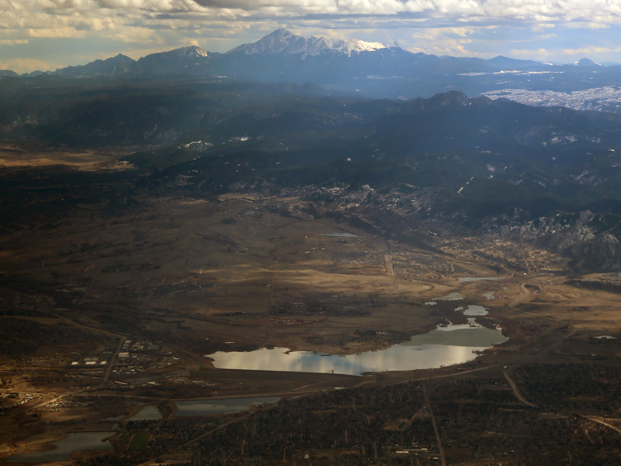
Chatfield Reservoir Hike
Difficulty Rating:
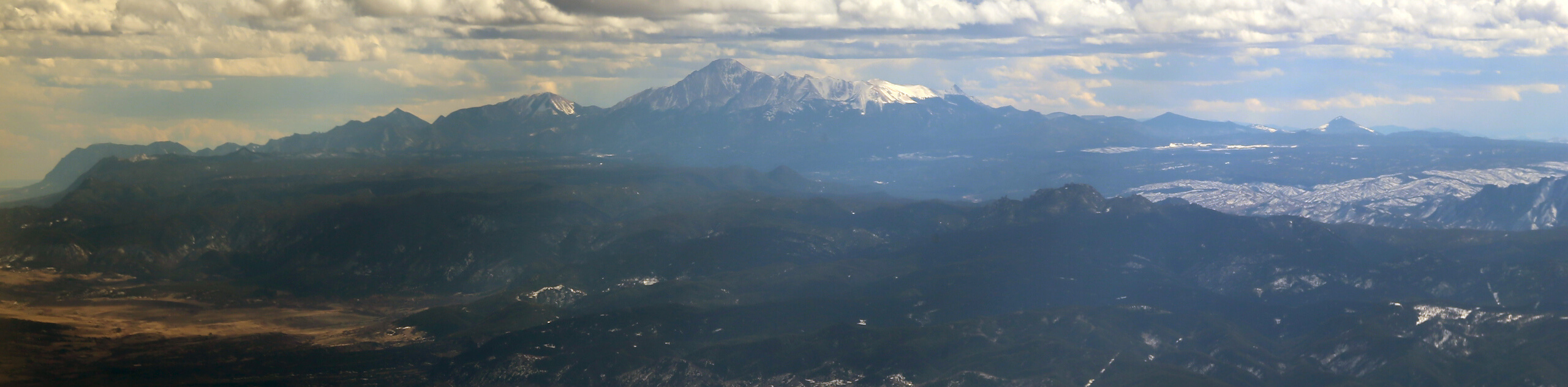
The Chatfield Reservoir Hike is an awesome, family-friendly adventure in the Chatfield State Park. This lovely shoreline path reveals epic views of the Front Range peaks that line the horizon. Versatile and level, this route is wheelchair- and stroller-friendly, and awesome for a scenic bike tour.
Getting there
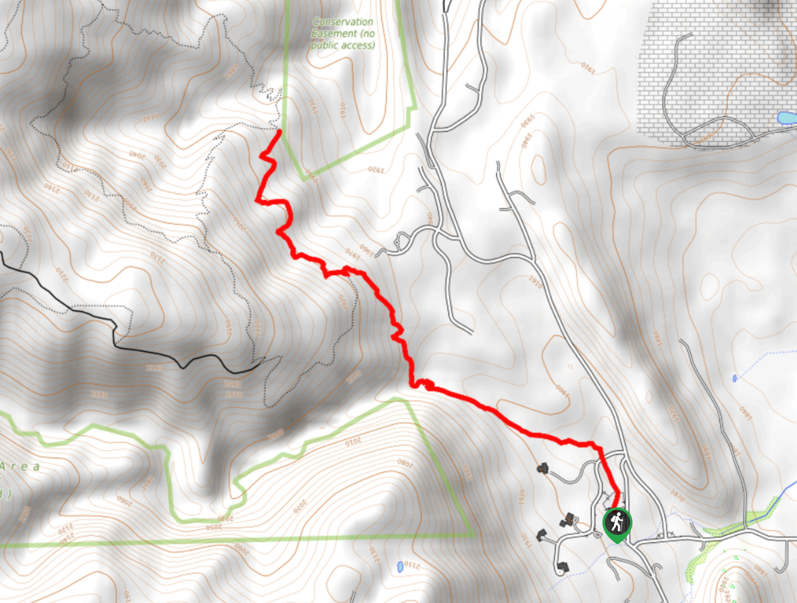
The Chatfield Reservoir Hike departs from the trailhead off the Perimeter Road in the Chatfield State Park.

About
| Backcountry Campground | |
| When to do | Year-round |
| Pets allowed | Yes - On Leash |
| Family friendly | Older Children only |
| Route Signage | Good |
| Crowd Levels | Moderate |
| Route Type | Circuit |
Chatfield Reservoir Hike
Elevation Graph
Weather
Chatfield Reservoir Hike Description
The Chatfield Reservoir Trail is a charming lakeshore adventure that exhibits the diversity of the Colorado wilderness. Trek through grassy plains which expose stunning mountain vistas and through dense verdant woodlands. The Chatfield Reservoir and State Park are popular destinations, notably in summer months. Many Denverites and tourists flock to the State Park to cool off in the summer months and adventure the scenic nature trails. If you are seeking a more secluded experience, then you may want to consider travelling further outside the city. Nevertheless, this is a great place to socialize and spend time outdoors. Note that the Chatfield State Park charges an entrance fee which typically costs around $10USD.
The beauty of the Chatfield Reservoir Trail is that it can be modified to your abilities and intentions. If you want a short nature walk along the shore you can turn around at any time and retrace your steps instead of trekking the entirety of the perimeter trail. The level grade and well-maintained path enable the accessibility of wheelchairs and strollers. Note there are steeper sections on the undulating path that those in a wheelchair or with a stroller may need help navigating. As you venture around the lake you will be granted views of the Denver cityscape, the Front Range peaks, and encompassing grassy plains. You will also be able to enjoy sights of those enjoying the reservoir’s waters: fisherman, kayakers, swimmers, and boaters all dot the inviting, blue-hued waters.
Begin your exciting journey around the Chatfield Reservoir Trail from the trailhead and parking lot off Perimeter Road. This excursion can be completed in either direction, but we recommend tracking clockwise. From the trailhead, take the rightmost trail signposted for the Chatfield Dam Trail. Venture this trail up the steep terrain up the dam. This section of the path passes through arid, exposed terrain, so keep an eye and ear out for rattlesnakes sunbathing on the rocks. Continue along this route, revelling in the sights of the Denver skyline and past the dog park. Soon the trail will divert you south, along the northeast shoreline of the Chatfield Reservoir.
As you trek south the path will briefly diverge from the shoreline and guide you beneath the tree coverage of towering pines. At the intersection, merge onto the Chatfield Internal Trail and follow this route as it intersects with Plume Creek. Eventually, the path will curve you north and out of the treeline. Hike along the shores and you will pass the boat launch and finishing pier. Follow the trail and it will reroute you south, along the eastern shoreline past the campground and Slocomb Cabin.
Revel in the mountainous views from the east shore and enjoy the sights of fellow adventurers enjoying the glittering waters of the reservoir. Eventually the route will guide you west over the South Platte River. At this point the path merges onto Platte River Trail, which veers north along the western shore. Hike along the ridge, passing the Chatfield Swim Beach. If you have your gear, hope in for a swim! Follow this route all the way back to the parking area and trailhead, marking the end of your Chatfield Reservoir Hike.
Trail Highlights
Chatfield Reservoir
The Chatfield Reservoir is an outdoor enthusiast’s haven in the summer months. Hike, bike, camp, horseback ride, run, swim, boat or fish, the Chatfield State Park packs a punch. The Chatfield Reservoir sits in the middle of the State Park and is the park’s main attraction, and rightfully so. Excellent for recreating, the reservoir also serves a purpose. The Chatfield Reservoir and Dam were built by the United States Army Corps of Engineers as a response to the area’s detrimental flooding in 1965. The construction of the reservoir and dam lasted from 1967 to 1975, and costs exceeded $74 million USD. Now a popular summer destination, the waters of the South Platte River are the primary inflow and outflow of the Chatfield Reservoir, which has a 47ft at its deepest point. The reservoir is a great place to spend a hot, sunny, summer’s day.
Frequently Asked Questions
How much does it cost to get into Chatfield State Park?
The entrance fee into the Chatfield State Park is typically around $10USD.
Can you swim in the Chatfield Reservoir?
Yes, there is an allocated beach on the Chatfield Reservoir where swimming is permitted.
What is the deepest depth of the Chatfield Reservoir?
The deepest part of the lake is approximately 47ft deep.
Can you fish in Chatfield Reservoir?
Yes, you can fish in Chatfield Reservoir assuming you have a legal Colorado fishing licence.
Can you boat in Chatfield Reservoir?
Yes, you can boat, sail, waterski or jet ski on the Chatfield Reservoir.
Insider Hints
Camp at the Chatfield State Park Campground for a few days for the ultimate immersive experience
Along the east side of the reservoir, you’ll find Living the Dream Brewing, which is a great spot to take a break and grab a cold beer before continuing your venture
Much of the path around the reservoir’s perimeter is exposed, so wear plenty of sunscreen
Similar hikes to the Chatfield Reservoir Hike hike

Singletree and Mayhoffer Trail
The Singletree and Mayhoffer Trail is a scenic adventure that will guide adventurers through the lush meadowlands that reveal sights…

Mount Galbraith via Cedar Gulch Trail
The Mount Galbraith via Cedar Gulch Trail is a charming adventure near Golden, Colorado that reveals the beauty and diversity…
Belcher Hill and Whippletree Trail
The Belcher Hill and Whippletree Trail is an exciting adventure—how could it not be with a name like that? The…
Comments