
Black Bear Trail
View Photos
Black Bear Trail
Difficulty Rating:
The Black Bear Trail is an awesome day-hike in the Golden Gate Canyon National Park. Hike beneath the shade of golden aspens interspersed with towering pines, and up the rocky terrain to a luxuriant meadow that exposes epic mountain views. This hike is a must add to your day-hikes near Denver list.
Getting there
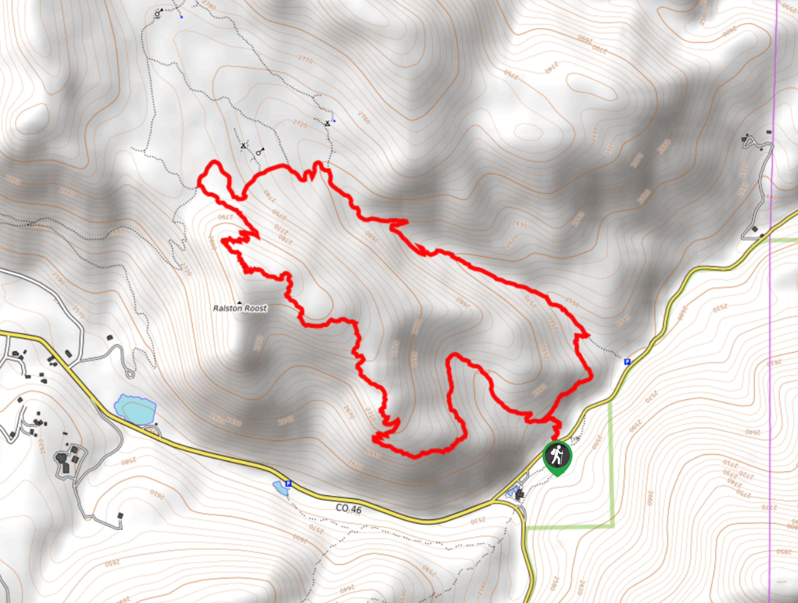
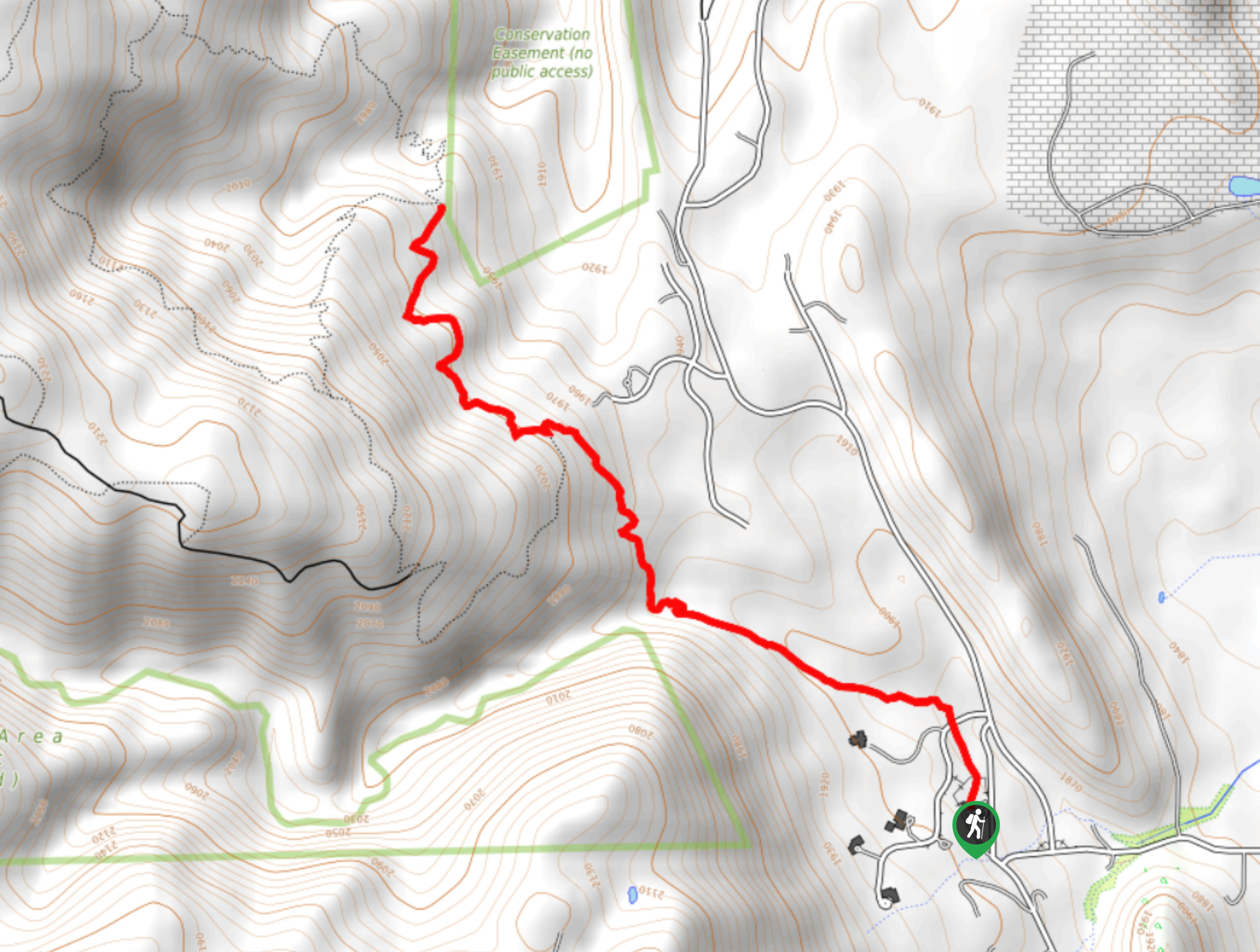
The Black Bear Trail departs from the parking lot and trailhead off Crawford Gulch Road.

About
| Backcountry Campground | Rim Meadow Dispersed Campground |
| When to do | May-November |
| Pets allowed | Yes - On Leash |
| Family friendly | Older Children only |
| Route Signage | Average |
| Crowd Levels | High |
| Route Type | Lollipop |
Black Bear Trail
Elevation Graph
Weather
Black Bear Trail Description
You can probably tell, but we love this hike. The Black Bear exhibits some of our favorite ecosystems: forestlands and meadows. You get the best of both worlds on this hike, both shaded verdant woodlands and open meadows that reveal sights of the encompassing snow-capped peaks of the Front Range, what more could you ask for? There are some steep sections, so be mindful of your footing, but they are nothing extreme. This path also is prone to moose and deer, so keep an eye out as you travel through the wilderness. Note that this hike is located within the State Park, so visitors are required to purchase a day pass, which typically costs around $6USD.
Embark on your adventure along the Black Bear Hike from the trailhead off Crawford Gulch Road. From here, the trek can be completed in either direction, but we prefer to hike clockwise on this one. Shortly after your departure from the trailhead, you will encounter an intersection, turn left here and you will begin your hike along the Black Bear Trail. Hike the path through the shade of the towering pines and aspen trees, minding your footing on the rocky terrain. Navigate a few sets of switchbacks up to the summit of a rocky ridge and hike the increasingly exposed terrain past Ralston Roost Peak to an intersection. At the junction, turn right onto Horseshoe Trail, tracking past the dispersed campsites through the meadowlands.
Keep an eye out for moose and grazing deer in this area. At the next fork, keep right along the gradually descending path. Follow the Horseshoe Trail back beneath the timberline and down through a forested Gulch. At the trail’s end, turn right and track the Black Bear/Horseshoe Connector Trail back to the trailhead, marking the end of your adventure.
Similar hikes to the Black Bear Trail hike

Singletree and Mayhoffer Trail
The Singletree and Mayhoffer Trail is a scenic adventure that will guide adventurers through the lush meadowlands that reveal sights…

Mount Galbraith via Cedar Gulch Trail
The Mount Galbraith via Cedar Gulch Trail is a charming adventure near Golden, Colorado that reveals the beauty and diversity…
Belcher Hill and Whippletree Trail
The Belcher Hill and Whippletree Trail is an exciting adventure—how could it not be with a name like that? The…
Comments