
Beaver Trail
View Photos
Beaver Trail
Difficulty Rating:
Hike the Beaver Trail through golden aspens, beneath the coverage of towering pines, through luxuriant meadows laden with elk, and up to a scenic overlook, what more could you ask for? If you are seeking a charming woodland and more secluded adventure, then the Beaver Trail checks that box. So, what are you waiting for?
Getting there
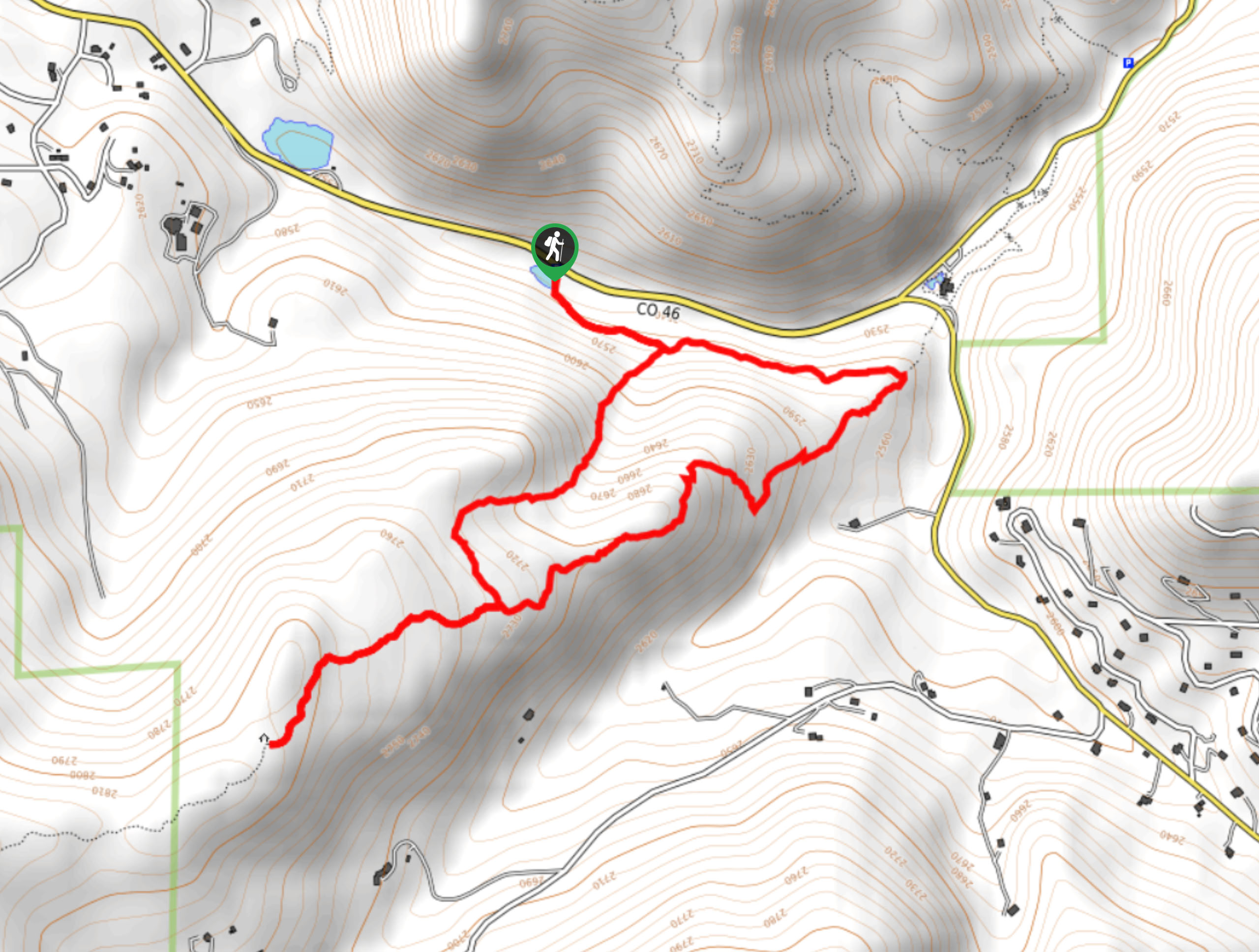
The Beaver Hike departs from the trailhead off Golden Gate Canyon Road.

About
| Backcountry Campground | No |
| When to do | April-October |
| Pets allowed | Yes - On Leash |
| Family friendly | Yes |
| Route Signage | Average |
| Crowd Levels | Moderate |
| Route Type | Lollipop |
Beaver Trail
Elevation Graph
Weather
Beaver Trail Description
The Beaver Hike is a lovely excursion through the Golden Gate Canyon State Park. This adventure bodes the possibility of spotting elk, deer, moose, or even bears! Though this path possesses limited elevation gain, it boasts expansive mountain views from its lookout. Perfect for a gentle nature walk or an introductory Front Range hike for the whole family, this trail may be our favorite in the State Park. Located within the State Park’s boundaries, visitors are required to purchase a $10USD day pass.
Embark on your adventure along the Beaver Trail from the trailhead that sits next to Slough Pond. From here, track the Beaver Trail southeast and at the intersection, keep right. Ascend the forested valley, keeping an eye out for moose and deer! As you climb, the terrain will become increasingly exposed as you near the lookout point. At the next junction, keep right, hiking to the shelter and overlook. From here enjoy views of the Front Range peaks. Revel in the scenery, then retrace your steps back to the junction. At this point, turn right, and you will be diverted down the easternmost Beaver Creek Trail.
This section of the path is more exposed, so keep an eye out for elk in the meadowland below. Trek this route down the rocky terrain, and at the next intersection, keep left. Cross the meadow and you will be delivered back to the trailhead.
Similar hikes to the Beaver Trail hike

Singletree and Mayhoffer Trail
The Singletree and Mayhoffer Trail is a scenic adventure that will guide adventurers through the lush meadowlands that reveal sights…
Hidden Fawn Loop Trail
The Hidden Fawn Loop Trail is a lovely meadowland adventure in the Alderfer/Three Sisters Open Space Park. Enjoy sights of…

Mount Galbraith via Cedar Gulch Trail
The Mount Galbraith via Cedar Gulch Trail is a charming adventure near Golden, Colorado that reveals the beauty and diversity…
Comments