
White Tor Walk
View Photos
White Tor Walk
Difficulty Rating:
The walk to White Tor is a spectacular adventure across the rugged terrain of Dartmoor National Park that will take you over several tors and past numerous historical sites. While out walking the trail, you will experience the beautiful moorland terrain that makes this barren area so beautiful, all while experiencing a blast from the past, as you witness the remains of Bronze and Iron Age huts, monuments, and hillforts that can be found scattered throughout the region. This is a fantastic walk for those with an interest in ancient history and beautifully scenic views.
Getting there
To reach the car park for the White Tor Walk from Tavistock, head east on Mount Tavy Road/B3357 for 3.2mi and turn left to enter the parking area.

About
| When to do | March-November |
| Backcountry Campsites | No |
| Pets allowed | Yes |
| Family friendly | Older Children only |
| Route Signage | Average |
| Crowd Levels | Moderate |
| Route Type | Circuit |
White Tor Walk
Elevation Graph
Weather
White Tor Walk Description
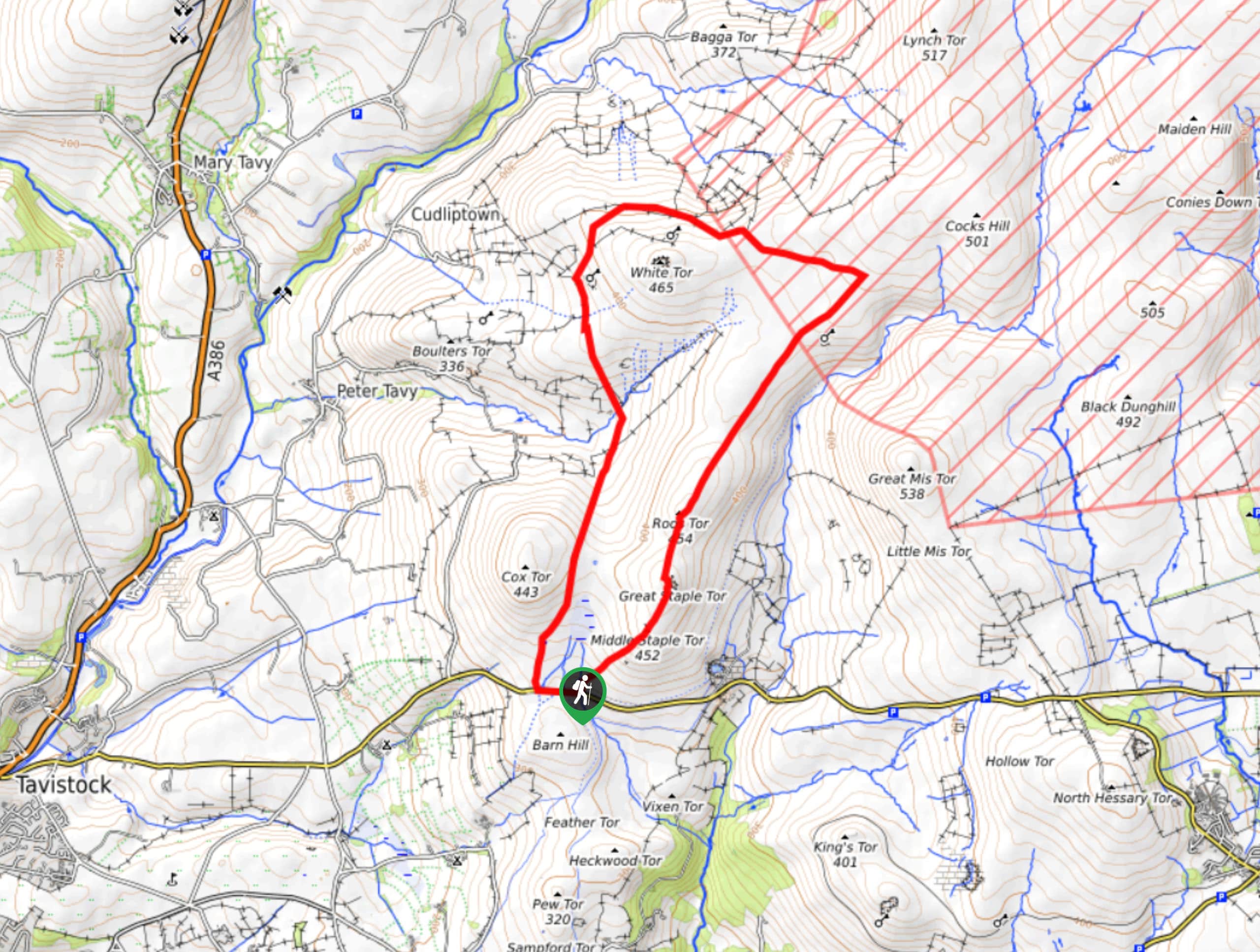
The terrain on the White Tor Walk is a bit rugged, but it is more than manageable for a variety of walkers; however, there is one thing to take note of. The northeast corner of the route borders the Ministry of Defense Merrivale Range, where military groups often perform training exercises. Pay attention to all posted signs and be aware of your surroundings when making your way through this area. Additionally, if there is no room for parking in the small lot near the trailhead, make your way a bit further to the west to the much larger Pork Hill car park.
Setting out from the car park, head to the northeast along the trail to traverse the rugged terrain that spans the summits of the Little, Middle, and Great Staple tors. From here, you will continue on across the undulating landscape of the moor to the northeast to make your way to the top of Roos Tor. Head down the opposite side of the hill and continue to the northeast to make your way across Langstone Moor, where you will find the remains of a cluster of stone huts that once formed a settlement during the Bronze Age. Shortly after this, the trail will turn to the west and pass by a standing stone monument before taking you up to the summit of White Tor. Here, you will be among the remnants of a hilltop fort that dates back to the Neolithic/Bronze Ages and provides a commanding view across the rugged Dartmoor landscape. After taking in the views, make your descent along the western slope of the hill and follow the trail south across the undulating landscape to return to the car park where you began.
Similar hikes to the White Tor Walk hike

Shipley Bridge and Avon Dam Reservoir Walk
Located in the southern part of Dartmoor National Park, the Shipley Bridge and Avon Dam Reservoir Walk is a lovely…

The Sherlock Holmes Track
The Sherlock Holmes Track is a fun adventure in the southeast corner of Dartmoor National Park that will take you…

Ryder’s Hill via Sandy Way Trail
The Ryder’s Hill via Sandy Way Trail is a beautiful walking route in Dartmoor National Park that will lead you…
Comments