Craigendarroch Summit Trail
View Photos
Craigendarroch Summit Trail
Difficulty Rating:
The Craigendarroch Summit Trail is a quick and fairly easy adventure in Cairngorms National PArk that will take you up a small hill for beautifully scenic views. While out walking the trail, you will loop around the forested slopes of Craigendarroch to reach its summit, where you will enjoy amazing views of Deeside. Although this route may be short, be sure to wear proper footwear.
Getting there
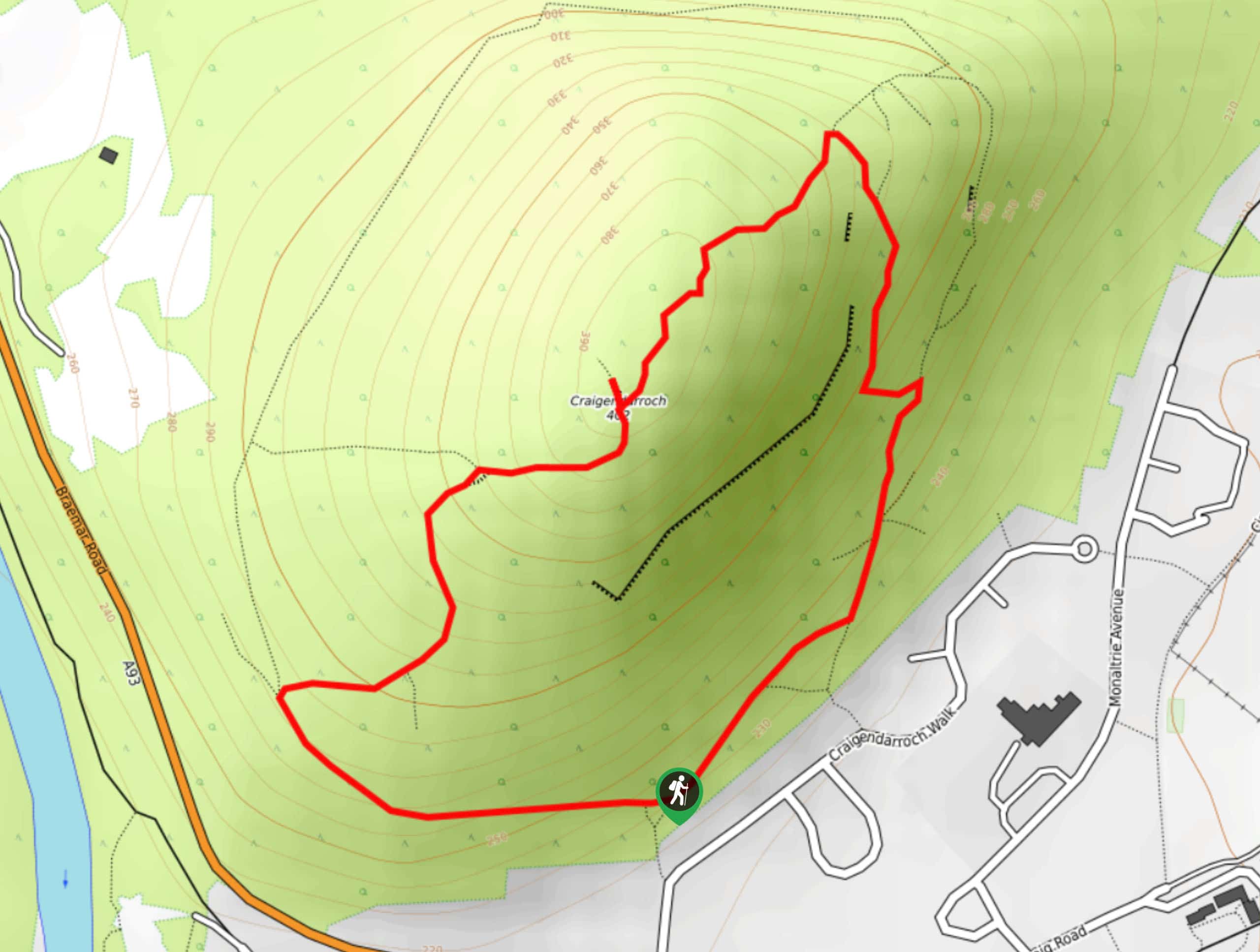
The trailhead for the Craigendarroch Summit Trail can be found at the corner of Braemar Road and Craigendarroch Walk.

About
| Backcountry Campground | No |
| When to do | Year-Round |
| Pets allowed | Yes - On Leash |
| Family friendly | Yes |
| Route Signage | Average |
| Crowd Levels | Moderate |
| Route Type | Circuit |
Craigendarroch Summit Trail
Elevation Graph
Weather
Craigendarroch Summit Trail Description
If you want to experience beautifully scenic views overlooking Deeside without the high level of effort required for a longer adventure in the area, then you should definitely check out the Craigendarroch Summit Trail. This quick journey will take you around the forested slopes of the hill for sweeping views across Cairngorms National Park.
Setting out from the trailhead at the edge of Braemar Road, you will head north along Craigendarroch Walk and pick up the footpath branching off to the left and into the forest. Here, you will begin climbing uphill around the western slope of Craigendarroch, which will begin to steepen and take you up to the summit. After taking in the beautiful views of Deeside, you will descend the northeast slope of the hill and continue south through the forest, eventually meeting up with your initial path that will take you back to the trailhead.
Similar hikes to the Craigendarroch Summit Trail hike

Glen Banvie Trail and Blair Castle Walk
The Glen Banvie Trail and Blair Castle Walk is a great adventure in Cairngorms National Park that takes in the…

Beinn Udlamain Munro and Sgairneach Mhòr Walk
The Beinn Udlamain Munro and Sgairneach Mhòr Walk is a rugged and exciting journey in Cairngorms National Park that will…

Loch an Eilein, Loch Gamhna, Old Logging Way Loop
The Loch an Eilein, Loch Gamhna, Old Logging Way Loop is a wonderful walking trail in Cairngorms National Park that…
Comments