
Craig Coillich Walk
View Photos
Craig Coillich Walk
Difficulty Rating:
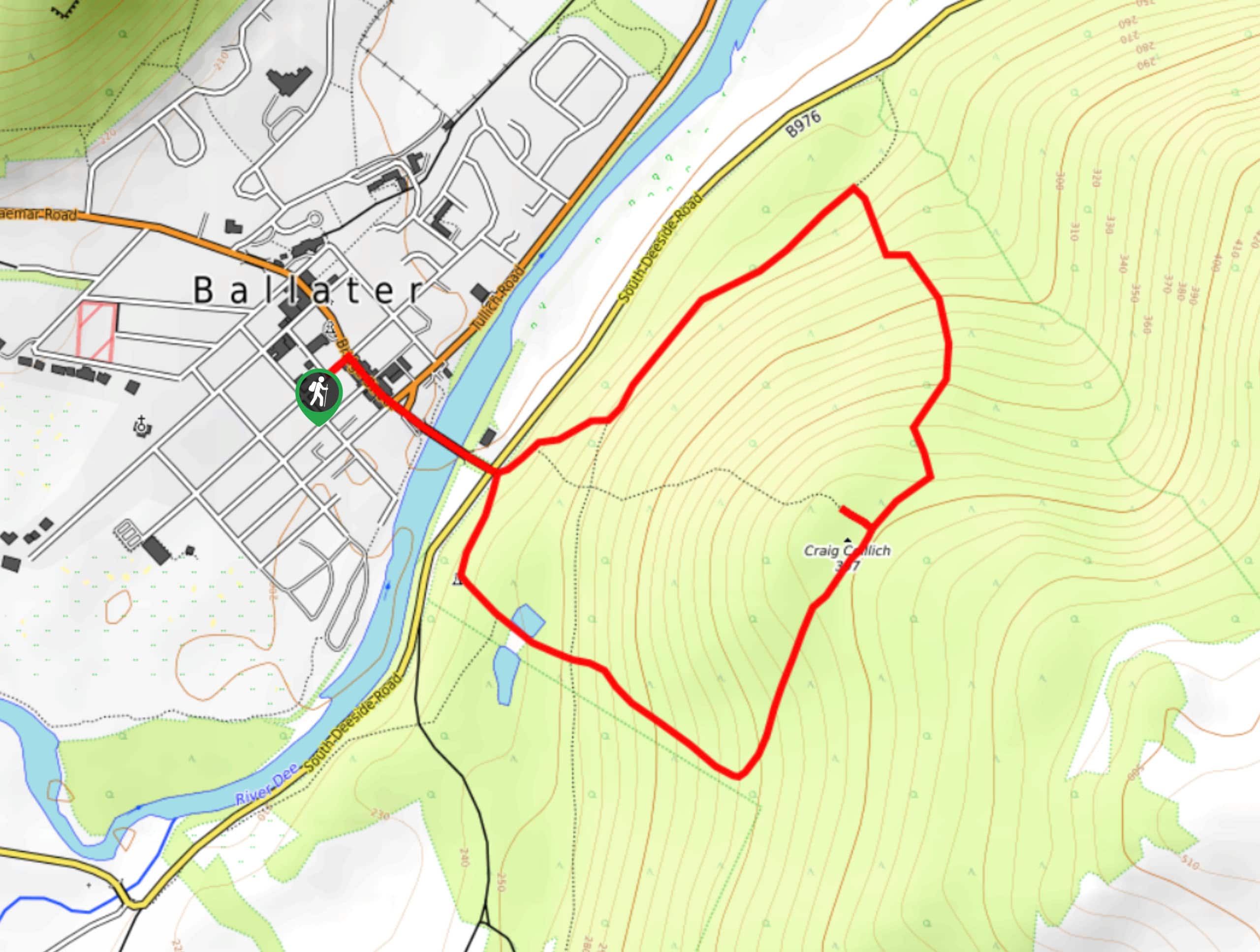
The Craig Coillich Walk is a short but steep walking route in Ballater that will take you uphill for some beautiful views of the surrounding Cairngorms NP terrain. While out walking the trail, you will cross over the River Dee and traverse the forested hillside to reach the summit of Craig Coillich, which offers wonderfully scenic views of Deeside. This is an exceptional adventure whether you are looking for a spot of exercise or simply to take in the scenery.
Getting there
The trailhead for the Craig Coillich Walk can be found at the Ballater car park in the heart of the village.

About
| Backcountry Campground | No |
| When to do | Year-Round |
| Pets allowed | Yes - On Leash |
| Family friendly | Yes |
| Route Signage | Average |
| Crowd Levels | Moderate |
| Route Type | Lollipop |
Craig Coillich Walk
Elevation Graph
Weather
Craig Coillich Walk Description
If you have been in search of a fun little trail that features scenic views of the River Dee, the village of Ballater, and the surrounding landscape of Deeside, then look no further than the Craig Coillich Walk in Cairngorms National Park.
Setting out from the car park in the heart of Ballater, you will make your way to the southeast through town in order to cross the bridge over the River Dee. From here, you will pick up a footpath directly after the bridge that will fork almost immediately. Take the path on the right here to enter into the forest and begin climbing the hillside.
Keeping on to the southeast, you will pass through a few junctions in the trail and eventually reach the summit of Craig Coillich, where you will enjoy some picturesque views that sweep across Deeside. From the summit, you will make your descent to the north, carefully working your way down the hillside to arrive at a lumber camp. Keep left here until you arrive back at the bridge and follow your same route back into the car park where you began.
Similar hikes to the Craig Coillich Walk hike

Glen Banvie Trail and Blair Castle Walk
The Glen Banvie Trail and Blair Castle Walk is a great adventure in Cairngorms National Park that takes in the…

Beinn Udlamain Munro and Sgairneach Mhòr Walk
The Beinn Udlamain Munro and Sgairneach Mhòr Walk is a rugged and exciting journey in Cairngorms National Park that will…

Loch an Eilein, Loch Gamhna, Old Logging Way Loop
The Loch an Eilein, Loch Gamhna, Old Logging Way Loop is a wonderful walking trail in Cairngorms National Park that…
Comments