Carn a’ Chlamain via Tilt Glen Walk
View Photos
Carn a’ Chlamain via Tilt Glen Walk
Difficulty Rating:
Walking up Carn a’ Chlamain via Tilt Glen is a very long and challenging adventure in Cairngorms National Park that features rough terrain and scenic views. While out walking the trail, you will follow along the winding banks of the River Tilt, before making the steep push up to the summit. Walkers should take note that this is a very difficult route that should only be undertaken by those who have experience with long mountain walks.
Getting there
The trailhead for the Carn a’ Chlamain via Tilt Glen Walk can be found at the Glen Tilt car park, just outside Blair Atholl.

About
| Backcountry Campground | No |
| When to do | Year-Round |
| Pets allowed | Yes - On Leash |
| Family friendly | No |
| Route Signage | Poor |
| Crowd Levels | Low |
| Route Type | Lollipop |
Carn a’ Chlamain via Tilt Glen Walk
Elevation Graph
Weather
Carn a’ Chlamain via Tilt Glen Walk Description
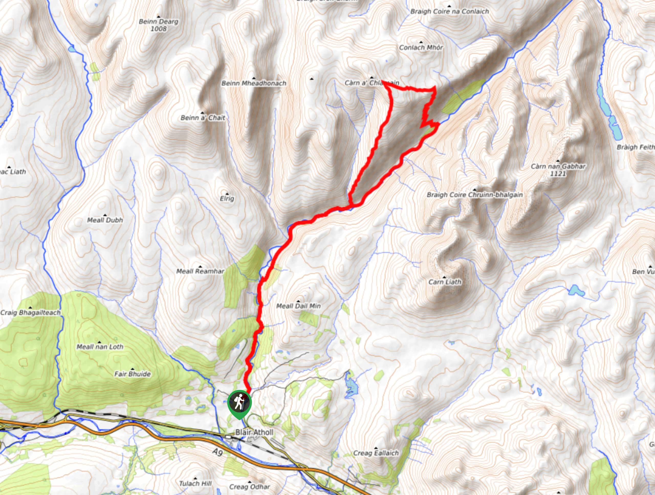
If you are after a rugged and challenging adventure that will take you on a nearly 18.6mi trek into the mountains for stunning views across Cairngorms National Park, then the Carn a’ Chlamain via Tilt Glen Walk will be the perfect route for you. Be sure to come prepared with all necessary gear and supplies for this long and strenuous walk.
Setting out from the Glen Tilt car park, you will head to the northeast and follow the River Tilt as it snakes its way through the wooded slopes of Glen Tilt. As you make the approach to Carn a’ Chlamain, you will branch off to the left and follow the route as it leads you up the mountainside. After trudging your way uphill, you will arrive at the summit, where you will enjoy spectacular views overlooking the glen and surrounding mountain peaks.
Once you have had your fill of the views, carefully make your way down the mountain to the east, following the switchback trail until you arrive at the edge of the River Tilt. From here, you will follow the banks of the river to the southwest to arrive back at the car park where you began.
Similar hikes to the Carn a’ Chlamain via Tilt Glen Walk hike

Glen Banvie Trail and Blair Castle Walk
The Glen Banvie Trail and Blair Castle Walk is a great adventure in Cairngorms National Park that takes in the…

Beinn Udlamain Munro and Sgairneach Mhòr Walk
The Beinn Udlamain Munro and Sgairneach Mhòr Walk is a rugged and exciting journey in Cairngorms National Park that will…

Loch an Eilein, Loch Gamhna, Old Logging Way Loop
The Loch an Eilein, Loch Gamhna, Old Logging Way Loop is a wonderful walking trail in Cairngorms National Park that…
Comments