Ben Macdui and Cairngorm Walk
View Photos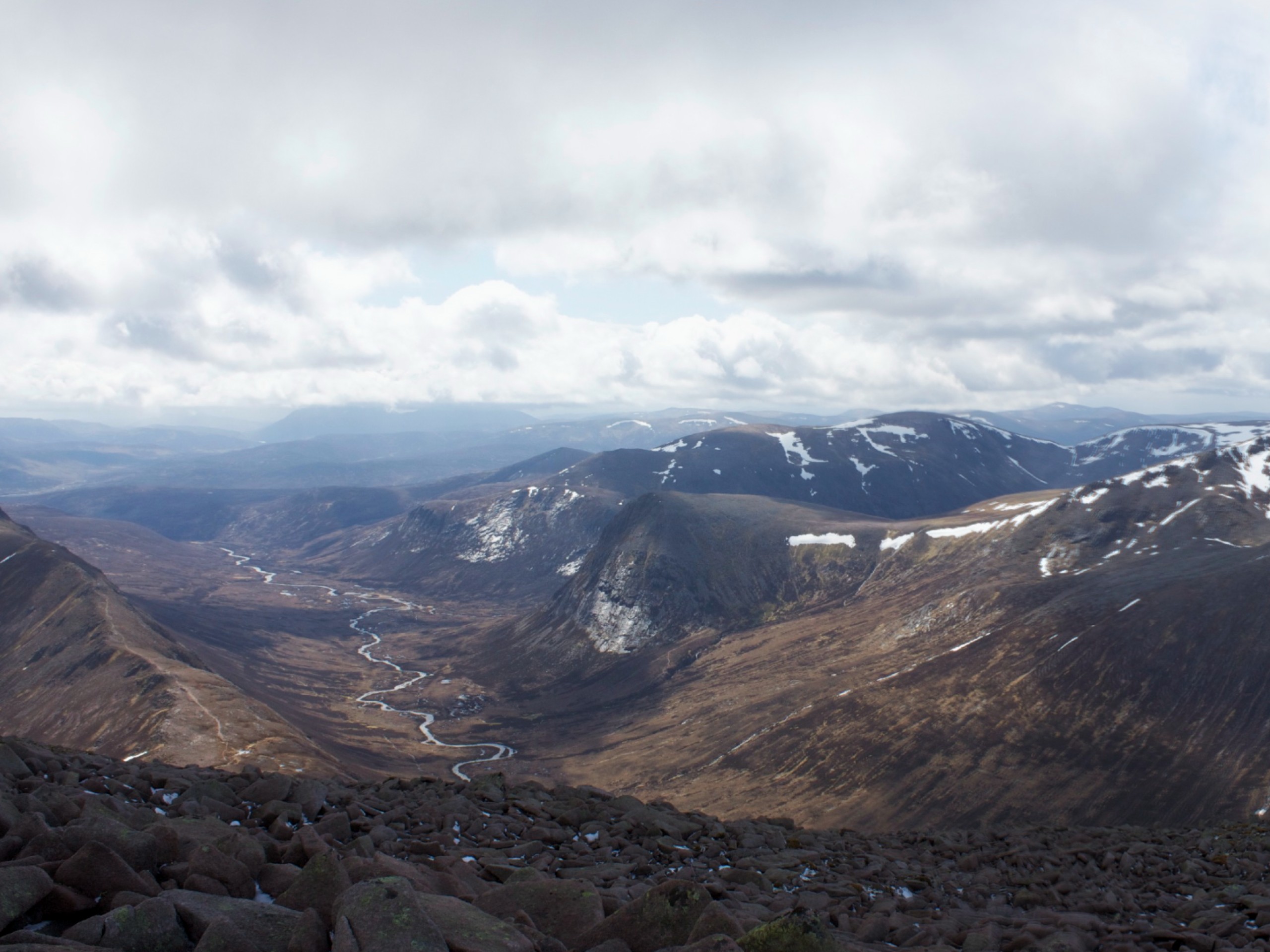
Ben Macdui and Cairngorm Walk
Difficulty Rating:
Strive to reach the summit (3058ft) of Scotland’s second-highest mountain on the gripping Ben Macdui and Cairngorm Walk in Aviemore, Scotland. The 10.9mi hillwalk is certainly not your average walk in the park, but for those seeking to conquer one of the more challenging hillwalks in Cairngorm National Park, this walk is for you! Featuring incredible views from the Cairngorm Plateau, wild river crossings and a triumphant final ascent across Ben Macdui’s northern flanks to reach the summit, this was packs a punch and if up for the challenge, you won’t want to miss it.
Getting there
To get to the Ben Macdui and Cairngorms Walk from Aviemore, take Craggan More Rd and Dalfaber Dr to Grampian Road/B9152 and continue for 1.0mi. Follow Grampian Rd/B19152 and B970 for 3.0mi, then continue straight on a limited-access road for 8.1mi (don’t turn left where the B970 forks.) When you reach signs for the Cairngorm Mountain Lower Car Park, turn right and continue 1.1mi, then keep right for the Cairngorm Mountain Upper Car Park, where the walk begins.

About
| When to do | Year-round access |
| Backcountry Campsites | Glenmore Campsite |
| Pets allowed | Yes - Off leash |
| Family friendly | No |
| Route Signage | Average |
| Crowd Levels | Moderate |
| Route Type | Circuit |
Ben Macdui and Cairngorm Walk
Elevation Graph
Weather
Ben Macdui and Cairngorm Walk Description
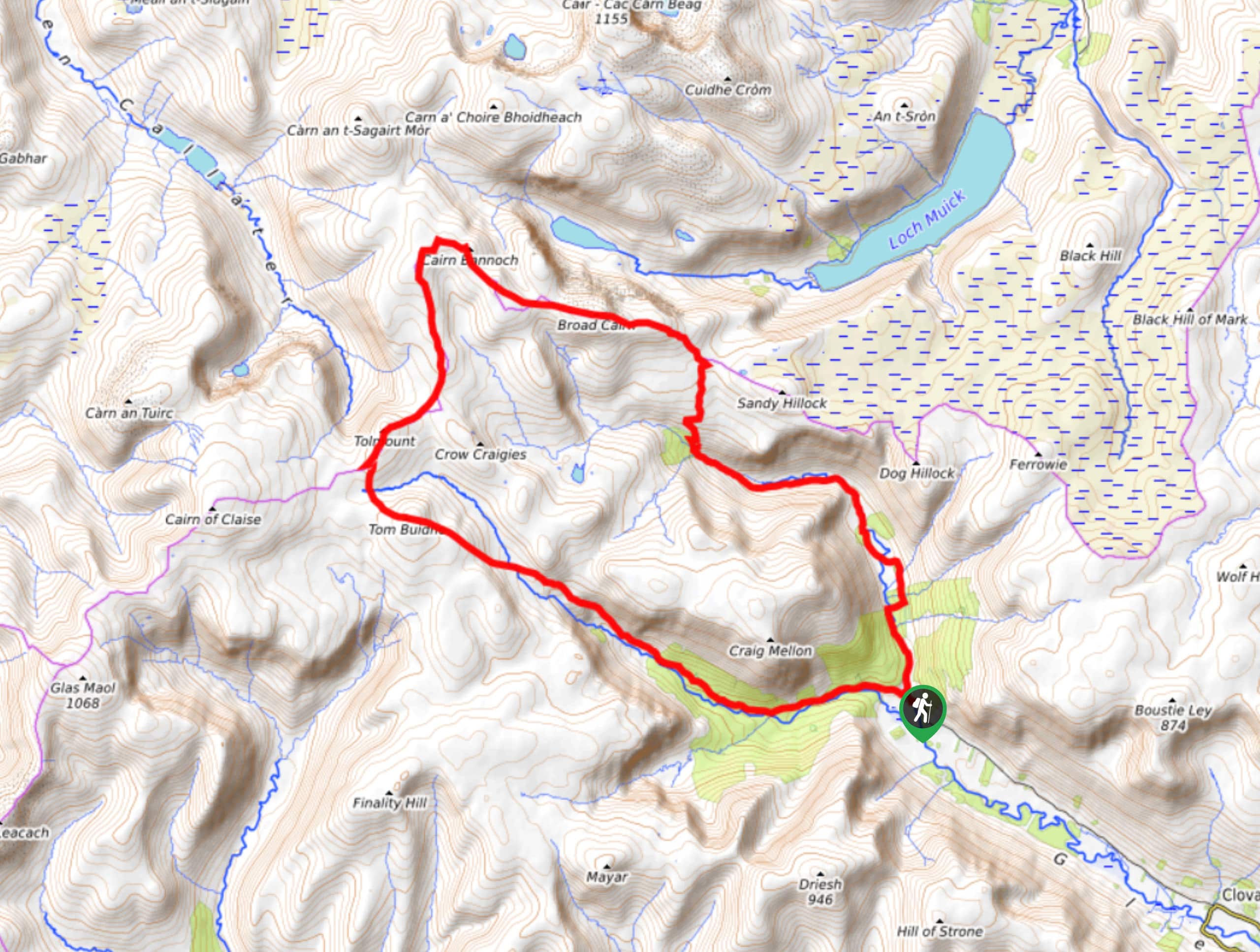
The Ben Macdui and Cairngorms Walk is a 10.9mi adventure across the arctic-like Cairngorm Plateau and to the impressive summit of Ben Macdui at 3058ft reaching 3058ft. You’ll find good paths on both the ascent and descent of the hill; however, walking the plateau poses navigational challenges, particularly when weather conditions are not ideal. Try to plan this walk when conditions are clear unless you have excellent navigational skills and a working knowledge of the park. The Cairngorm plateau, due to its exposure, is treacherous when snow is present. Winter hillwalking skills and equipment, such as an ice axe and crampons, are highly recommended when tackling this hill during the winter.
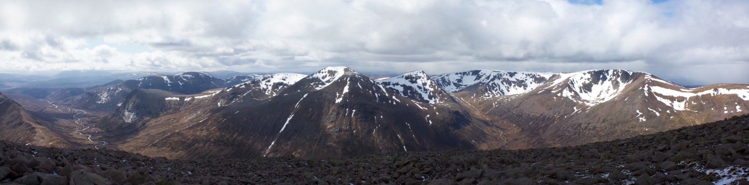
From the undulating, arctic wilderness of the Cairngorms Plateau to the awe-striking views from the trail and atop Ben Macdui’s summit, this walk is nothing short of spectacular. As the second-highest mountain in Scotland (behind Ben Nevis), Ben Macdui is a highly coveted hill to bag, making this a must-do walk for those looking to reach epic heights!
From the Cairngorm Ski Centre car park, set out up the ski track then across, just below the northern corries. You’ll traverse some steps downwards as you head west, crossing a bridge and looking for the path on the far side. Some further steps lead you up and position you to cross the moor, setting you up to join another path after crossing. As you approach a fork, prepare to keep to the lower path on the right, leading you across the moor and the Allt Coire an t-Sneachda. Another fork soon appears, and you’ll want to stick to the wider, lower path.
Cross the meandering stream and pursue the path that now leads up the expansive ridge of Miadan Creag an Leth-Choin. It’s here when the views begin to really set in, as vistas greet you over the gulf of Coire an Lochain on your left. Above the ridge, you’ll make your way through a boggier section but will have a chance to catch your breath here as the trail flattens out. Hugging the slopes of Cairn Lochain’s west side, you’ll continue, keeping to the right of Lochan Buidhe. The path soon fades as you tackle a boulder field to reach a path on the other side, which takes you across the plateau.
Spot Cairn Toul and Braeriach rising triumphantly as you look out across the Lairig Ghru and prepare to traverse the rocky tundra ahead. Continue in a series of brief descents and ascents until you hit the extended climb, which has you crossing the northern flanks of Ben Madui’s. Press on towards the summit, which is marked by a gigantic cairn with a trig point. Revel in the views that envelop you as you check Britain’s second-highest mountain off your list and spend as long as you’d like, revelling in the epic scenery.
To descend, retrace your steps, sticking to the path on your right hand, however, which passes closer to Lochan Buidhe. You’ll find yourself crossing the slopes on (a usually) very clear path, especially in the summer months. With the headwaters of Feith Buidhe below, enjoy the return walk, soon reaching the northern corries edge and the bealach between Stob Coire an t-Sneachda and Cairn Lochan.
Head over Stob Coire an t-Sneachda and note that the incredible views just keep coming! Continue to the Fiacaill a’Choire Chais’ ridge to proceed with a straightforward, reasonably easy descent. Continuing north on the descent towards the Ptarmigan restaurant, you’ll pass to the right of the restaurant building, walking down “Windy Ridge Path,” which crosses a ski run and eventually heads left and continues to descend back to the car park where the walk began.
Trail Highlights
Ben Macdui
Ben Macdui is a 4295ft mountain in Scotland’s Cairngorms National Park and holds the impressive title of Scotland’s second-highest mountain. It is the highest mountain in the Cairngorms and is a classified Marilyn, Munro, Council Top, and County Top. At age 40, Queen Victoria climbed the peak, reaching the summit in 1859. Today, it’s a popular hillwalk for those looking for a challenging full-day adventure.
Cairngorm Plateau
Known as the highest, the coldest, and the snowiest plateau in all of Britain, the Cairngorm Plateau is an anomaly in Scotland, with its arctic-like rolling tundra and year-round snow patches. The plateau has a subarctic climate and is often compared to arctic regions in the European Alps or the Canadian Arctic. The plateau provides an opportunity to hike in a rare setting in Scotland. Still, due to extreme exposure and significant height, precautions should always be taken and weather carefully considered when walking the plateau.
Lairig Ghru
Lairig Ghru is a mountain pass and is the most well-known hill-pass in all of Scotland. It reaches an altitude of 2740ft and unfolds through the central Cairngorms.
Other Great Walks in Cairngorms National Park
Check out our trail guides to Loch Muick, Ben Vrackie, Loch an Eilein, and the Mount Keen Walk. Or see all of our Cairngorms walks.
Insider Hints
The car park at Cairngorm Ski Centre charges £2 per vehicle seasonally from June to October.
The Cairngorm Ski Centre features a gift shop and Cafe, perfect for warming up with a hot drink. after the walk or snagging some mountain souvenirs (open 7 days a week).
Toilet facilities can be found in the Cairngorm Ski Centre.
The Ptarmigan Restaurant restaurant that you pass towards the end of the walk is closed permanently due to damage to the funicular track.
The nearby town of Aviemore is a tourist resort and features several great restaurants and accommodations if you wish to extend your stay beyond the walk.
Similar hikes to the Ben Macdui and Cairngorm Walk hike

Glen Banvie Trail and Blair Castle Walk
The Glen Banvie Trail and Blair Castle Walk is a great adventure in Cairngorms National Park that takes in the…

Beinn Udlamain Munro and Sgairneach Mhòr Walk
The Beinn Udlamain Munro and Sgairneach Mhòr Walk is a rugged and exciting journey in Cairngorms National Park that will…
Cairn of Gowal Loop
The Cairn of Gowal Loop is a rough and rugged excursion in Cairngorms National Park that will take you over…
Comments