Badenoch Way Trail
View Photos
Badenoch Way Trail
Difficulty Rating:
The Badenoch Way Trail is an exceptional walking route in Cairngorms National Park that will take you through a lovely stretch of woodland terrain with rocky crags and charming lochs. While out walking the trail, you will climb uphill through the forest along the Badenoch Way, before visiting the lookout at Farleitter Crag and descending along Uath Lochan. Be sure to exercise caution along the cliffs at Farleitter Crag, as there are some steep drop offs that could prove dangerous.
Getting there
The trailhead for the Badenoch Way Trail can be found at the Uath Lochans car park, just 8.4mi northeast of Kingussie.

About
| Backcountry Campground | No |
| When to do | Year-Round |
| Pets allowed | Yes - On Leash |
| Family friendly | Yes |
| Route Signage | Average |
| Crowd Levels | Moderate |
| Route Type | Lollipop |
Badenoch Way Trail
Elevation Graph
Weather
Badenoch Way Trail Description
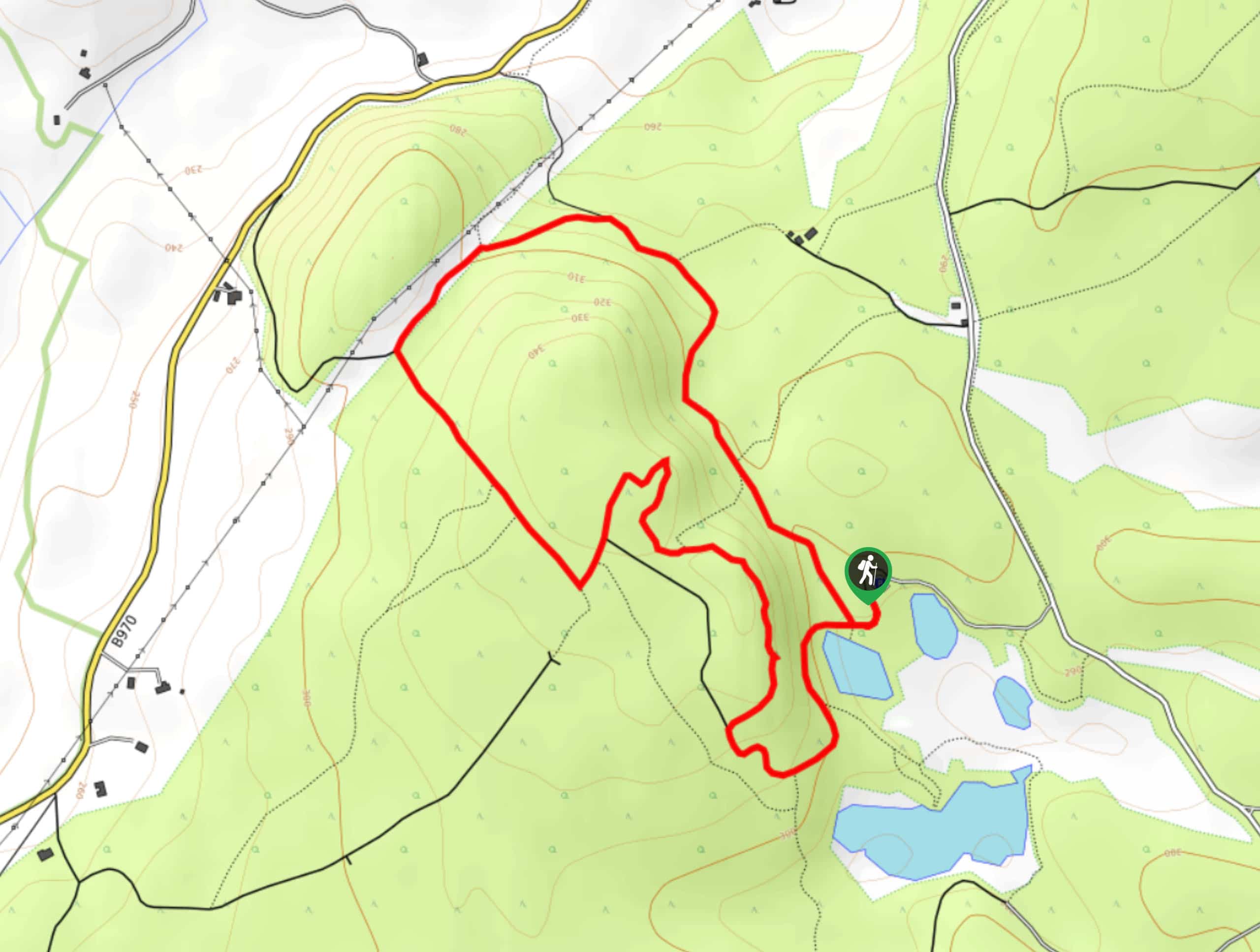
Featuring several charming lochs, a beautiful woodland setting, and scenic views from atop Farleitter Crag, the Badenoch Way Trail is a fantastic adventure in Cairngorms National Park that the entire family will be able to enjoy.
Setting out from the car park, you will initially follow the track to the southwest as it skirts around the edge of a small loch, before turning to the northwest through the beautiful forest terrain. Eventually, the track will meet up with the Badenoch Way and pass through a clearing to the southwest, climbing uphill before entering back into the dense cover of the wood.
Here, you will head to the southeast to reach Farleitter Crag, a scenic cliffside lookout that offers some fantastic views of the surrounding landscape. Continuing on to the southeast, you will traverse the edge of the crag, before making your way downhill towards Uath Lochan, passing it by on the way to the trailhead where you began.
Similar hikes to the Badenoch Way Trail hike

Glen Banvie Trail and Blair Castle Walk
The Glen Banvie Trail and Blair Castle Walk is a great adventure in Cairngorms National Park that takes in the…

Beinn Udlamain Munro and Sgairneach Mhòr Walk
The Beinn Udlamain Munro and Sgairneach Mhòr Walk is a rugged and exciting journey in Cairngorms National Park that will…

Loch an Eilein, Loch Gamhna, Old Logging Way Loop
The Loch an Eilein, Loch Gamhna, Old Logging Way Loop is a wonderful walking trail in Cairngorms National Park that…
Comments