Eagle, Hidden Valley, and Cobalt Trail
View Photos
Eagle, Hidden Valley, and Cobalt Trail
Difficulty Rating:
The Eagle, Hidden Valley, and Cobalt Trail is a lovely adventure along a meadow-laden loop trail. Revel in the sights of the Flatirons, foothills, Boulder Reservoir, and Hogback Ridge. Escape the city and let Colorado’s fresh air fill your lungs.
Getting there
The Eagle, Hidden Valley, and Cobalt Trail departs from the Eagle Trailhead off N 55th Street.

About
| Backcountry Campground | No |
| When to do | Year-round |
| Pets allowed | Yes - On Leash |
| Family friendly | Yes |
| Route Signage | Average |
| Crowd Levels | Moderate |
| Route Type | Lollipop |
Eagle, Hidden Valley, and Cobalt Trail
Elevation Graph
Weather
Eagle, Hidden Valley, and Cobalt Trail Description
The Eagle, Hidden Valley, and Cobalt Trail is a must add to your Boulder adventure itinerary. Hike in the company of mountain bikers and horseback riders as you trek along the wide, dirt path through the meadowlands. Relatively secluded compared to the neighboring Boulder Reservoir Trail, this nature walk is an awesome option for those seeking a more relaxing and quiet adventure. When hiking this path in the summer months, be sure to keep an eye and ear out for rattlesnakes.
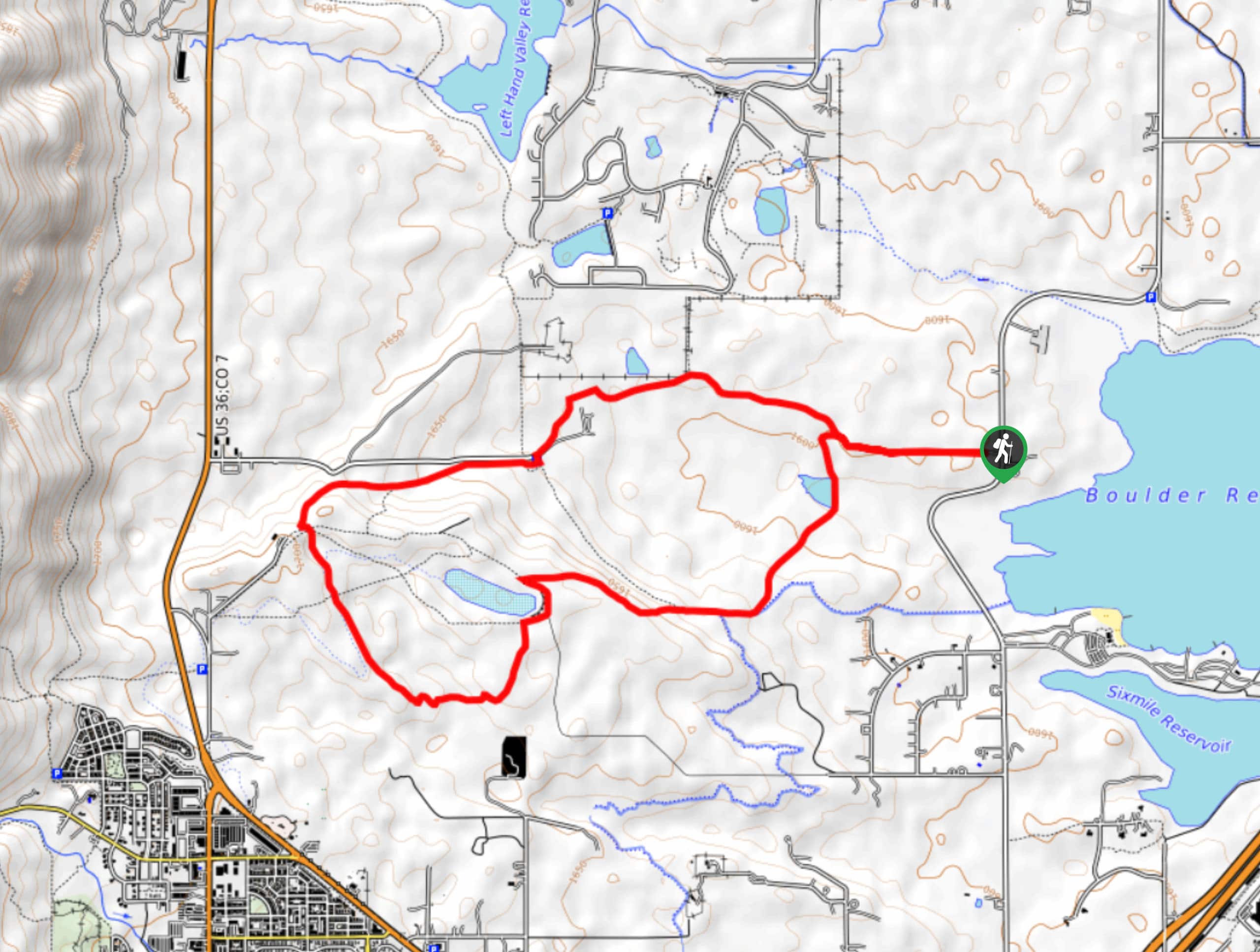
Embark on your journey along the Eagle, Hidden Valley, and Cobalt Trail from the Eagle Trailhead. From here, track west along the path to the first intersection. At this point, keep left, passing the Boulder Valley Ranch Pond. Hike the Eagle Trail up a small mesa, to the Mesa Reservoir. Here, veer left, and you will be diverted onto the Hidden Valley Trail. Track this path along a small stream before confronting a confusing intersection. At this junction, take the Cobalt Trail, merging onto the Sage Trail at the path’s end.
Follow the Sage Trail through the meadowlands, revealing sights of the Boulder Reservoir. Soon you will reconnect with the Eagle Trail. Turn left and retrace your footing east along this path back to the trailhead.
Similar hikes to the Eagle, Hidden Valley, and Cobalt Trail hike

NCAR to Fern Canyon Hike
The NCAR to Fern Canyon Hike is an awesome but challenging adventure up to the summit of Nebel Horn. Put…

Crown Rock Trail
The Crown Rock Trail is a short but sweet nature walk that presents the perfect excuse to get the family…

Rattlesnake Gulch Trail
The Rattlesnake Gulch Trail is an epic adventure through the Eldorado Canyon State Park. Ascend the steep cliffs of Eldorado…
Comments