
Mystic Pass Backpacking Trail
View Photos
Mystic Pass Backpacking Trail
Difficulty Rating:
If you are interested in the Sawback Trail but don’t have 5-7 days to complete it, try out the three-day Mystic Pass Trail. This trail begins at Mount Norquay and travels up Forty Mile Creek to summit Mystic Pass. It descends on the north side of the pass to join Johnston Creek and continue on to Johnston Canyon.
Getting there
From the Town of Banff find Lynx street and follow this towards the Trans-Canada Highway. Pass over the highway on the overpass as you join Mount Norquay Road. This road switchbacks steeply up the side of the mountain before reaching the parking lot. If you’re lucky, you will be able to spot some bighorn sheep or even a bear along the way.

About
| When to do | July-September |
| Backcountry Campsites | Mount Cockscomb Fm10, Mystic Junction Fm19, Mystic Valley Mi22, Larry’s Camp Jo9 |
| Pets allowed | Yes - On Leash |
| Family friendly | Older Children only |
| Route Signage | Average |
| Crowd Levels | Moderate |
| Route Type | One Way |
Mystic Pass Backpacking Trail
Elevation Graph
Weather
Mystic Pass Backpacking Trail Description
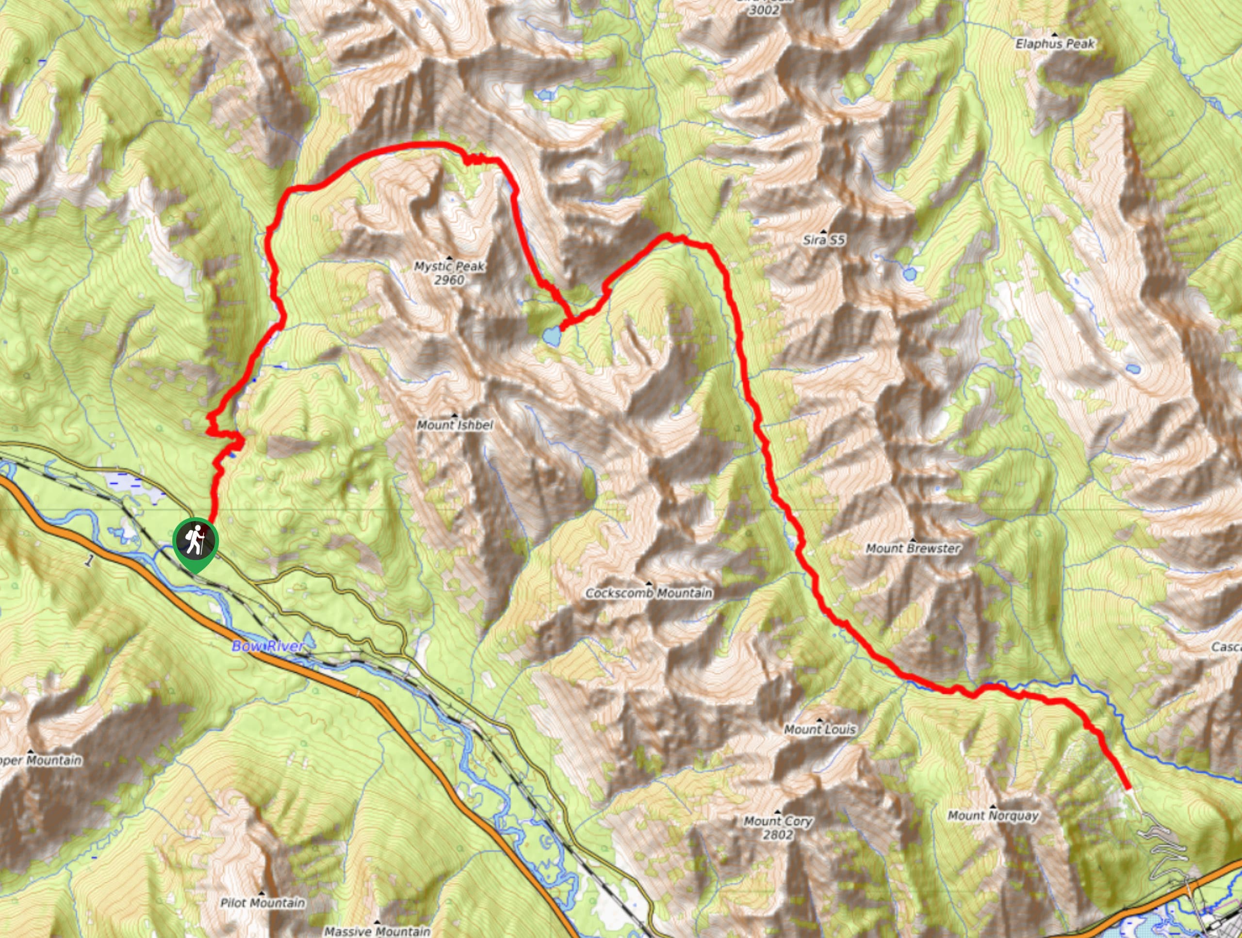
Starting at the Mount Norquay parking lot, begin walking towards the ski lodge. There is no defined trail here, but you will pass the lodge and continue towards the ski lifts. Pass under the Cascade, Spirit, and Mystic chairs before you reach a trail sign and small junction with two defined trails. Stay left following signs for Fm10. Begin your hike up Forty Mile Creek and watch for bears! This is a popular wildlife corridor, and carrying bear spray is a must.
Travel 12.2mi and 356.0mi of elevation gain to reach Mystic Junction (Fm19) camp. This is a quiet camp in the woods near the Mystic Lake warden cabin. You may be tempted to push your miles for Mystic Lake Mi22 camp; however, you should know it is not at the lake. It is a few kilometres from the lake and not worth the extra mileage.
On day two, depart Mystic Junction heading towards Mystic Lake. There is a slight detour to the lake that is well worth it. Be sure to accommodate some time to visit the lake before you begin climbing Mystic Pass. This day will take you 7.6mi from Mystic Junction to Larry’s Camp (Jo9). It rises 1421ft in elevation on the gentler side of the pass before dropping down 1949ft into the next valley. It is a scenic route and the most enjoyable stretch of this trail.
Larry’s camp is a manageable 4.6mi of mostly downhill terrain to the Johnston Canyon Resort and trailhead, stopping at the Ink Pots on your return. This natural water feature is a popular destination for day hikers.
Similar backpacking trails to the Mystic Pass Backpacking Trail backpacking trail
Pharaoh Creek Backpacking Trail
The Pharaoh Creek backpacking trail follows the same route that many take to reach Egypt Lake and it’s cascading counterparts.…
Og Lake Backpacking Trail
The Og Lake backpacking trail is a great option for those who can’t make a reservation at the busy Lake…
Merlin Lake Backpacking Trail
The backpacking route to the Merlin Lake Trail follows the main Skoki route and covers all the popular landmarks in…
Comments