
Face Mountain Trail
View PhotosFace Mountain Trail
Difficulty Rating:
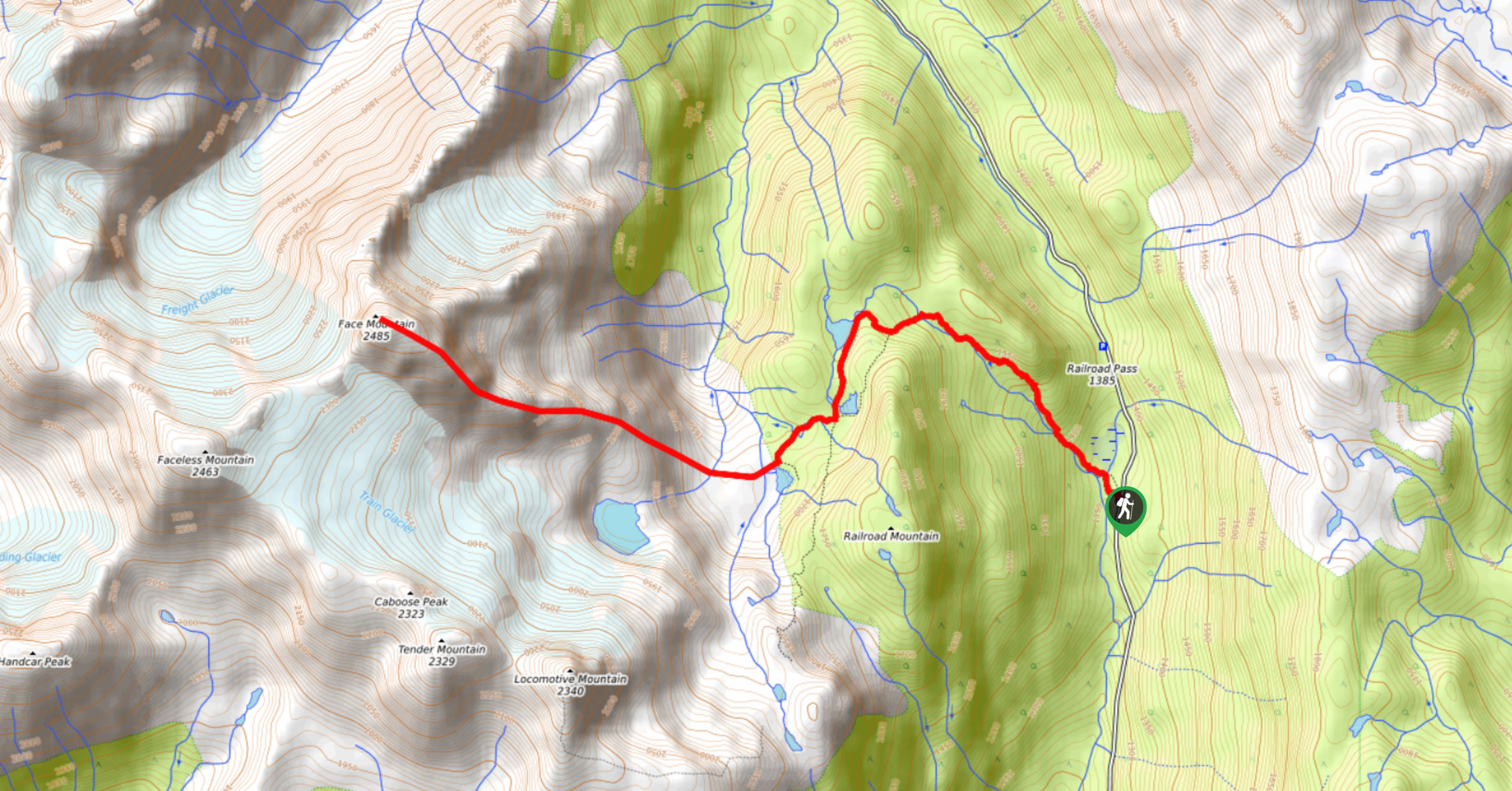
The Face Mountain Trail is a challenging out-and-back hiking route near Pemberton that takes hikers on a difficult scramble to the summit of the mountain. You’ll pass by the scenic Semaphore Lakes along the trail before heading on a route up the mountain that will take you to the rock slab peak. This peak has some truly stellar views for those who can navigate the route, but it should be noted that only experienced adventurers should attempt this trail.
Getting there
To access the parking area for the Face Mountain Trail from Pemberton, drive north on Pemberton Meadows Road for 14.6mi and turn right onto Lillooet Forest Service Road (FSR). Follow this for 0.9mi and turn left at the first cross street. Continue for 7km and turn right onto Hurley River FSR, which you will stay on for 6.0mi to find the parking area on your left.

About
| When to do | June–October |
| Backcountry Campsites | No |
| Pets allowed | No |
| Family friendly | No |
| Route Signage | Poor |
| Crowd Levels | Low |
| Route Type | Out and back |
Face Mountain Trail
Elevation Graph
Weather
Face Mountain Trail Description
The Face Mountain Trail is a challenging route near Pemberton that leads to the Semaphore Lakes before a tough scramble to the summit of Face Mountain. This route is not a beginner hike. Anyone attempting to summit the peak should have route-finding experience and bring proper gear such as a helmet, crampons, or microspikes. A great resource for finding a safe route up the mountain is Matt Gunn’s book highlighting different scrambles in southwest BC. Those that can complete the challenging scramble will be treated to phenomenal views from the rock slab summit that overlooks the surrounding mountain peaks and nearby Freight and Train Glaciers. After taking in the spectacular sights, head back down Face Mountain to return to the trail that will take you to your vehicle.
Similar Scrambles to the Face Mountain Trail Scramble
Place Glacier Trail
The Place Glacier Trail is a difficult 6.8mi hiking route near Pemberton that climbs steeply uphill to some…
Joffre Peak via Cerise Creek Trail
The Joffre Peak via Cerise Creek Trail is a 9.5mi out-and-back climbing route near Pemberton that will take…
Polar Peak Ridge Trail
The Polar Peak Ridge Trail is a challenging 3.5mi route near Fernie that traverses an alpine ridge and…
Comments