North Fork of Taylor Creek Trail
View Photos
North Fork of Taylor Creek Trail
Difficulty Rating:
The North Fork of Taylor Creek is the least-hiked trail along Taylor Creek. Solitude and rugged terrain are almost guaranteed on this hike. If you're looking to get away from the crowds of the Middle Fork and visit a little-seen section of the Kolob Canyons area, this is a great hike for you.
Getting there
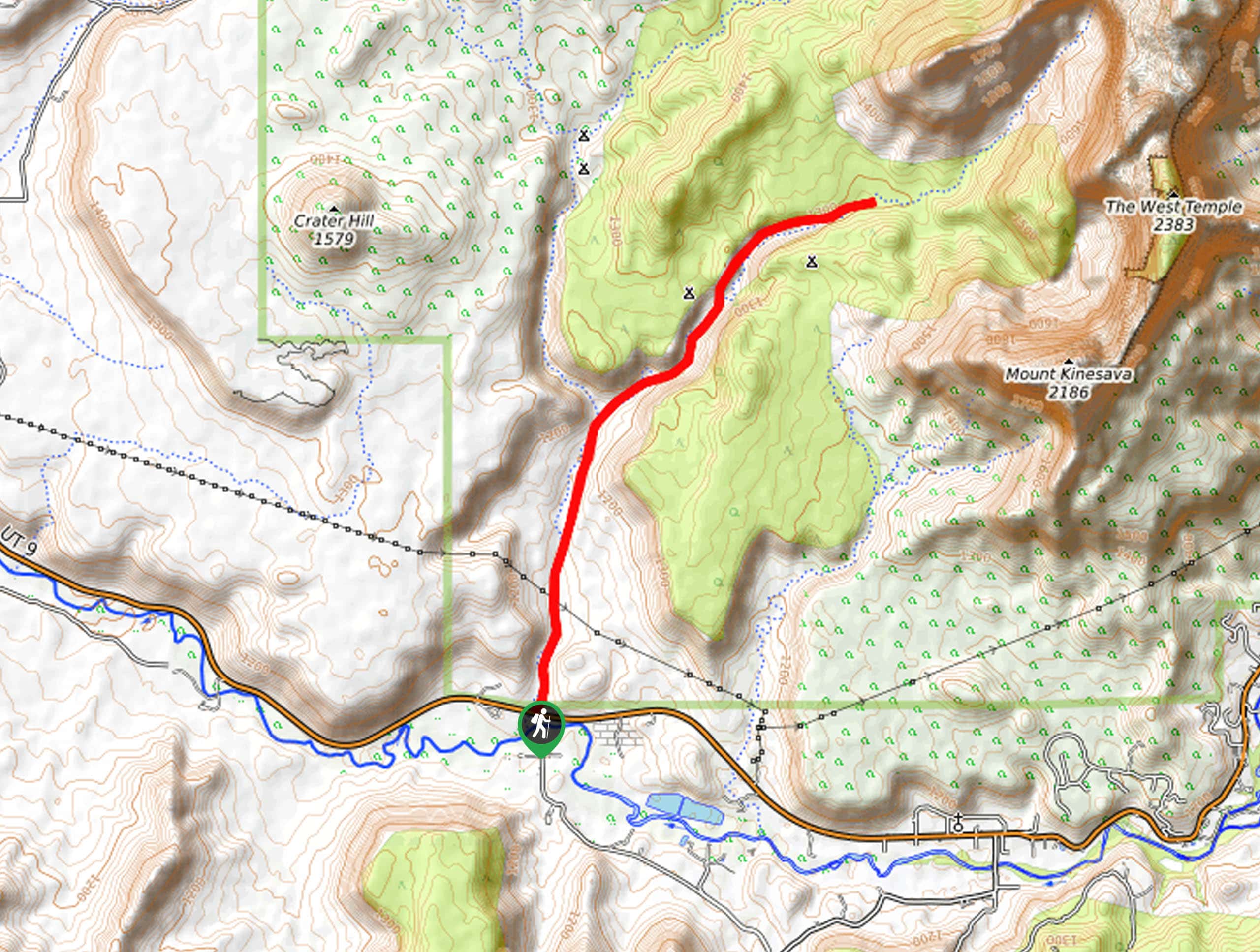
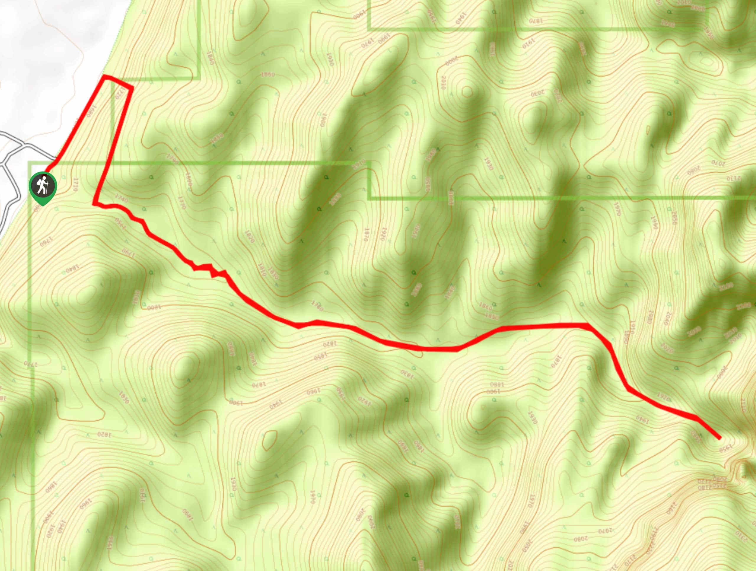
The North Fork of Taylor Creek Trail begins at the Middle Fork Taylor Creek Trailhead, just 2.0mi down Kolob Canyons road from the Kolob Visitor Center off of highway 15.

About
| Backcountry Campground | No |
| When to do | May to October |
| Pets allowed | No |
| Family friendly | Yes |
| Route Signage | Poor |
| Crowd Levels | Low |
| Route Type | Out and back |
North Fork of Taylor Creek Trail
Elevation Graph
Weather
North Fork of Taylor Creek Trail Description
The North Fork of Taylor Creek Trail offers a beautiful and secluded hike right next to the popular Middle Fork trail. The North Fork Trail is more adventurous than its cousin, so be prepared to do some creative route finding and some tromping through overgrown sections. This trail is unmaintained by the National Park Service, so wearing solid, sturdy shoes is a good idea.
From the trailhead parking lot on the north side of Kolob Canyons road, follow the trail east down a set of steep wooden stairs. The North Fork Trail trail follows the Middle Fork of Taylor Creek for the first mile. Just before the confluence of the North and Middle Forks of Taylor Creek, there is a short spur trail on the left (north) side of the creek. A short walk up this trail will bring you to the historic Larson Cabin. This cabin was built as a homestead by Gus Larson, an academic at the Branch Agricultural College, in 1930. Follow the path past the cabin and look and listen for the trickle of the North Fork of Taylor Creek. Follow the creek bed upstream as it begins to dry up. Parts of the trail may be overgrown, but soon enough you will get gorgeous views of the towering red sandstone, standing vibrant against the clear blue sky. Continue hiking for the next mile or so until you reach a boulder field. This is your cue to turn back and head home.
If you are still looking for more adventure, the Middle Fork trail can be a great addition to your day. Both hikes are definitely do-able in one day trip, just make sure you have enough water packed. The water in Taylor Creek is not safe to drink, even when treated, and the heat of the desert demands that you remain vigilant about your hydration.
Similar hikes to the North Fork of Taylor Creek Trail hike
Zion Ponderosa Checkerboard Trail
The Zion Ponderosa Checkerboard Trail is an easy walk that the whole family can enjoy. This trail is shared by…
Scoggin’s Wash
The Scoggin’s Wash Trail is a true desert hike that links the more popular Coalpits Wash Trail with the iconic…
Camp Creek Trail
The Camp Creek Trail is a rarely visited path down a beautiful box canyon in the Kolob section of Zion.…
Comments