Jack and George Mountain Trail
View Photos
Jack and George Mountain Trail
Difficulty Rating:
Jack and George Mountain Trail is a quick hike in Tucson, but even though it’s short, it has enough elevation gain to get your legs working. It’s a great pick for early birds who want a pre-work workout or for those days when you want some fresh air but are short on time. This route isn’t marked, though, so make sure you have a map or GPS track on hand. Keep an eye out for deer and enjoy being able to hike without leaving the city limits. Expect light traffic.
Getting there
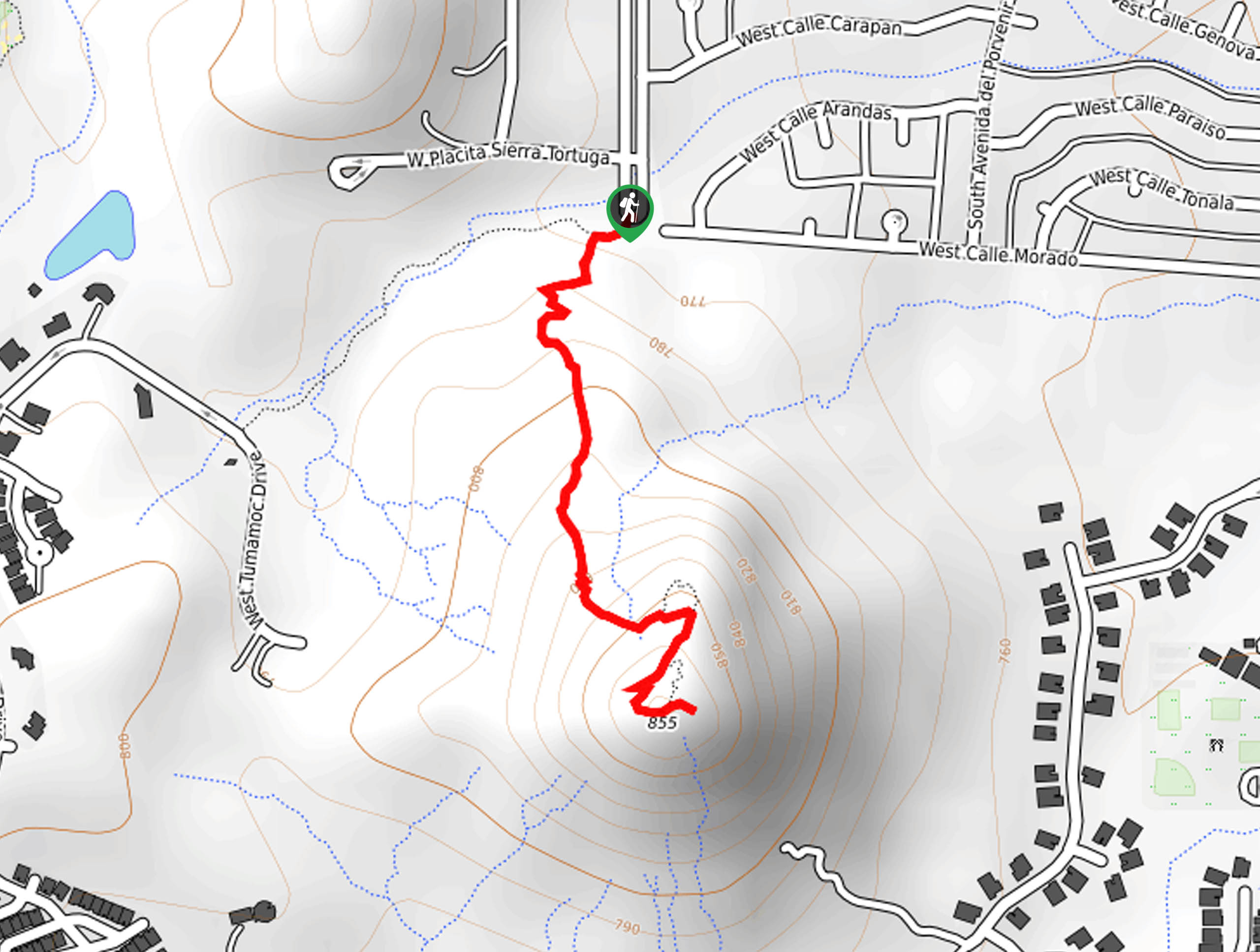
The trailhead for the Jack and George Mountain Trail is at the end of S Shannon Road.

About
| Backcountry Campground | No |
| When to do | October-May |
| Pets allowed | Yes - On Leash |
| Family friendly | Yes |
| Route Signage | Poor |
| Crowd Levels | Low |
| Route Type | Out and back |
Jack and George Mountain Trail
Elevation Graph
Weather
Jack and George Mountain Trail Description
The Jack and George Mountain Trail is the epitome of short and sweet. It will take most hikers less than an hour to complete and it offers nice views of the city and mountains surrounding it. This route is a good quick win early in the morning or after a long day when you need a bit of fresh air.
This route is poorly marked. Well, it’s really not marked at all. The trailhead is also blocked off from the road you’ll use to access it (Shannon), so go through the gate on the right side, look to your left, and you should see the trail there. Dogs are permitted on this trail as long as they’re on leash.
From the trailhead, locate the route heading up the mountain. The trail isn’t marked or clear at times, so a GPS route can be helpful. You’ll ascend the mountain from the north. There are some loose patches of gravel, so watch your footing as you climb. It’s a somewhat steep but short ascent, and from the top, you can look out over Tucson. When you’re ready, turn back and retrace your steps, keeping an eye out for the deer that frequent this area.
Similar hikes to the Jack and George Mountain Trail hike

Shantz, Cholla, and Cactus Forest Loop
The Shantz, Cholla, and Cactus Forest Loop is an easy trail in Tucson’s Saguaro National Park East. The star of…

Cactus Forest, Squeeze Pen, and Pink Hill Loop
The Cactus Forest, Squeeze Pen, and Pink Hill Loop is an easy trail in Tucson’s Saguaro National Park East. This…

Hugh Norris, Sendero Esperanza, and Dobbie Wash Loop
The Hugh Norris, Sendero Esperanza, and Dobbie Wash Loop is a bit of a mouthful, but it’s a great hike…
Comments