
50 Year Trail
View Photos
50 Year Trail
Difficulty Rating:
If a casual, meandering desert walk sounds like the right adventure for you, head up to the 50 Year Trail north of Tucson. This route is used by hikers, mountain bikers, and horseback riders alike. It’s a mostly flat trail, making it suitable for all ages and skill levels. Those who prefer big views and a physical challenge will likely prefer other trails, but keep this one in mind for a casual nature walk. Expect moderate traffic.
Getting there
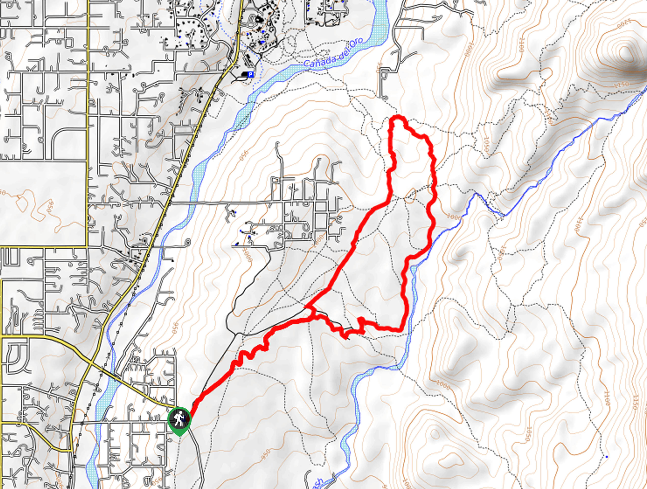
The trailhead for the 50 Year Trail is on Golder Ranch Road.

About
| Backcountry Campground | No |
| When to do | October-May |
| Pets allowed | Yes - On Leash |
| Family friendly | Yes |
| Route Signage | Average |
| Crowd Levels | Moderate |
| Route Type | Loop |
50 Year Trail
Elevation Graph
Weather
50 Year Trail Descritpion
The 50 Year Trail is located north of Catalina State Park on the north end of Tucson. This route is a very laid-back trip through the desert, with pleasant views and almost no elevation gain to consider. It’s good for families and beginner hikers and also used by horseback riders and mountain bikers. Hikers who prefer a physical challenge and bigger views might prefer other routes, but this is a good one to keep in mind for a relaxed nature walk.
Remember to share the trail because of its mixed traffic. Announce yourself to horseback riders if passing from behind.
From the trailhead, take North Equestrian Trail to 50 Year Trail. You’ll weave up to where the loop splits. Keep right and hike towards the Sutherland Wash. You’ll follow this wash for a while before the trail pulls away, heading straight north. When you reach The Chutes, take this route south, completing the loop and returning to 50 Year Trail and the equestrian track to arrive back at the trailhead. If you find this area confusing, a downloaded GPS track can help you stay on the right trail.
Similar hikes to the 50 Year Trail hike

Shantz, Cholla, and Cactus Forest Loop
The Shantz, Cholla, and Cactus Forest Loop is an easy trail in Tucson’s Saguaro National Park East. The star of…

Cactus Forest, Squeeze Pen, and Pink Hill Loop
The Cactus Forest, Squeeze Pen, and Pink Hill Loop is an easy trail in Tucson’s Saguaro National Park East. This…

Hugh Norris, Sendero Esperanza, and Dobbie Wash Loop
The Hugh Norris, Sendero Esperanza, and Dobbie Wash Loop is a bit of a mouthful, but it’s a great hike…
Comments