Devil’s Bridge Hike
View Photos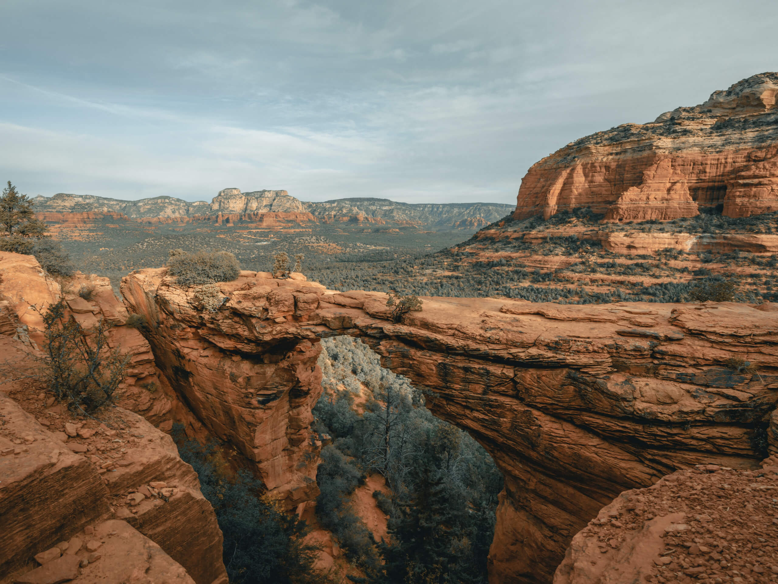
Devil’s Bridge Hike
Difficulty Rating:
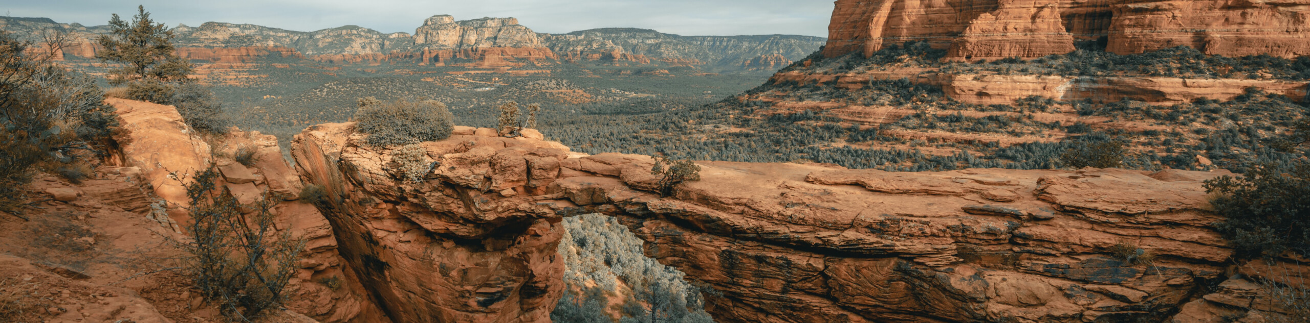
Devil’s Bridge is a natural sandstone bridge in Sedona, Arizona. This geological feature is the star on this very popular moderate trail. Climb out onto the bridge and gaze over a great view of the iconic red rocks of Sedona. This is a fun hike for most ages and definitely one to bring a camera for.
This hike is either 2.0mi long or about 45.0mi long depending on which trailhead you start at. With a 4X4 vehicle, you can drive up to the actual trailhead for the hike for a shorter walk. Without a 4X4, you’ll need to hike up one of two access roads. This guide starts from the Dry Creek Road trailhead, which is where most hikers without a 4X4 vehicle start (those with one can drive up Dry Creek Road). Expect heavy traffic on this very popular trail. Arriving early is a must in the busy season (April-May and October).
Getting there
The trailhead for Devil’s Bridge is at the start of Dry Creek Road.

About
| Backcountry Campground | No |
| When to do | Year-round |
| Pets allowed | Yes - On Leash |
| Family friendly | Yes |
| Route Signage | Good |
| Crowd Levels | High |
| Route Type | Out and back |
Devil’s Bridge Hike
Elevation Graph
Weather
Devil’s Bridge Hike Description
Devil’s Bridge is one of the most popular hikes in the Sedona area. At the end of this trail, a delicate sandstone bridge extends across Red Rock Country and the viewing area next to it provides a perfect spot to snap photos from. This hike captures some of the magic that Sedona’s rock formations are known for.
This hike is rated as moderate. Most of the trail is gradual, but there’s a steep incline near the end that may require a bit of hands-on help for some. Active children and beginners should still be able to make it, especially since the steep climbing section has some rocky steps to help you out.
The actual trailhead for this hike is about two miles up Dry Creek Road. If you have a high-clearance vehicle, you can drive up to the trailhead and shorten the hike. Don’t attempt this if you’re not in a capable vehicle, though. There are large rocks on the trail that could damage smaller vehicles. You can park at the Dry Creek Road parking area and walk the extra distance.
We strongly recommend arriving as early as you can- this parking area will fill up and there will be a line at the bridge for pictures. If you can start hiking as soon as there’s daylight, you’ll have the least crowded experience.
From the Dry Creek Road parking lot, take the obvious path across the creek bed and slowly uphill. The first section of the hike up to the actual trailhead is dusty and not incredibly scenic, so we recommend putting your head down and hiking quickly to have more time to enjoy the bridge.
At a 4-way junction, look for the trail on your far right. The scenery improves as you near the bridge (although the scenery in Sedona is nearly always great), and you’ll start gradually gaining more elevation.
At the scrambling section, make use of the step-shaped rocks and climb up. From here, you can either kick back on the viewing area and admire the bridge or climb over the arch for a photo. There’s also a trail on the left that takes you underneath the bridge if you want to gaze up at it.
Head out onto the bridge if you’d like. Little ones might benefit from having their hands held as the bridge is fairly exposed. On busy days, you will need to wait in line for a photo, sometimes for quite a while.
Look out at your incredible surroundings, which include the Grassy Knolls, Mescal Mountain, Capitol Butte, and Maroon Mountain. Once you’re ready, retrace your steps to the parking lot.
Trail Highlights
Devil’s Bridge
Devil’s Bridge is the largest natural sandstone arch in the Sedona area. It’s accessible on a fairly quick and easy hike and draws a high number of visitors each year.
Frequently Asked Questions
Is Devil’s Bridge a vortex hike?
No, it’s not a vortex hike. Try the Airport Mesa hike if you want to visit a vortex.
Has anyone ever fallen off Devil’s Bridge?
There have been a couple of people who fell off the bridge. We recommend caution as you navigate the bridge.
Is Devil’s Bridge free?
You’ll need to grab a daily Red Rock Pass for $5 at the trailhead. This gives you all-day access to Red Rock Country Trails. Weekly and annual passes are also available.
Insider Hints
Sedona can be very hot in the summer months. If you’re hiking between June and September, we recommend hiking early in the morning to avoid the heat of the day. Bring lots of water.
This hike gets busy! Try visiting early in the morning or later in the afternoon to miss most of the crowds.
If there’s no more parking at the trailhead, you can start from the Mescal Trailhead instead.
Planning a trip to Sedona? See if you can get a reservation at the excellent (but very busy) Elote Cafe.
Similar hikes to the Devil’s Bridge Hike hike

Margs Draw Trail
Margs Draw Trail is a bit of a hidden gem. This trail doesn’t get as much traffic as other nearby…

Baby Bell, Llama, and Bail Loop
The Baby Bell, Llama, and Bail Loop is a 3.6mi hike in Sedona near Bell Rock and Courthouse…

Herkenham Trail
Herkenham Trail is a 2.0mi out and back trail in the Coconino National Forest near Sedona. This route…
Comments