
Wyming Brook and Rivelin Reservoir Walk
View PhotosWyming Brook and Rivelin Reservoir Walk
Difficulty Rating:
The Wyming Brook and Rivelin Reservoir Walk is a 6.3km lollipop route that takes you through the dense woodland terrain surrounding the upper and lower Rivelin Reservoirs. Along the trail, walkers will experience a tranquil forest atmosphere filled with moss-covered trees and small, trickling waterfalls that give this former hunting ground an almost magical feel. This is a perfect walk for the entire family to get out and explore the natural beauty of the forest.
Getting there
To get to the Wyming Brook and Rivelin Reservoir Walk car park from Sheffield, head west on the A57 for 0.9mi and make a slight right to continue on for another 0.7mi. Turn left onto Sandygate Road, following it for 0.9mi. Keep right to continue on Redmires Road for 2.5mi and turn right to enter the car park.

About
| When to do | Year-Round |
| Backcountry Campsites | No |
| Pets allowed | Yes - On Leash |
| Family friendly | Yes |
| Route Signage | Average |
| Crowd Levels | Moderate |
| Route Type | Lollipop |
Wyming Brook and Rivelin Reservoir Walk
Elevation Graph
Weather
Wyming Brook and Rivelin Reservoir Walk Description
The Wyming Brook and Rivelin Reservoir Walk is a popular route for walkers and outdoor education activities, which might increase foot traffic along the path during peak hours. Make sure to arrive early to secure parking at the trailhead. Additionally, there are a few bits of rocky terrain along the brook that might impede travel for some walkers; however, these are more than manageable if you are cautious. A fair stretch of the northern part of the walk also follows along the A57, making for the least exciting part of the journey until you are able to round the reservoir and get back to more scenic terrain.
Although the route loses a few points for the stretch along the A57, the majority of the trail passes through a breathtaking stretch of forest terrain that you can explore to your heart’s content. Historically, the forests and crags around Wyming Brook were part of the Rivelin Chase hunting grounds that were reserved for the nobility; however, the area is now a protected nature reserve that the public can take full advantage of. Whether you are looking for a bit of peace and quiet along the trails or are after a fun family adventure, The Wyming Brook and Rivelin Reservoir Walk is a perfect option close to Sheffield.
Setting out from the car park, make your way north along the track for 150ft and take the path branching off to the right. From here, follow the trail into the forest and cross over the flowing waters of Wyming Brook before turning left at the first junction in the trail. In 120ft, you will cross the brook once again by means of a bridge before continuing on for 0.5mi through the lush cover of the wood. As you make your way through this serene stretch of woodland trail, you will travel closely along the edge of Wyming Brook, crossing over it several times as it approaches the calm waters of the Rivelin Lower Reservoir.
After making your way down a series of steps, you will come to a kissing gate at the edge of Wyming Brook Drive. Pass through the gate and head to the left, following the track through the beautiful atmosphere of the forest for 0.7mi, where you will come to a bridge over Reddicar Clough. Cross over the bridge and continue along the track for another 0.5mi, enjoying the shade of the tree canopy as the path meanders through the forest and meets up with Rivelin Brook, running alongside it until you arrive at another bridge.
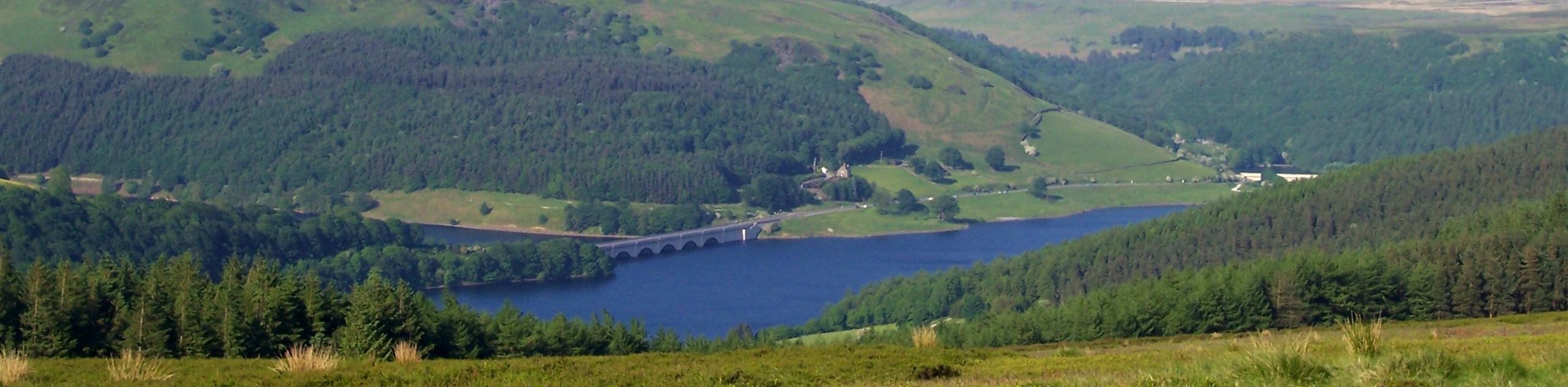
Make your way across the brook and head right at the junction, where you will eventually come to a gate next to a car park. Pass through the gate and make your way east along the A57 for the least scenic and exciting part of the walk, taking in some views of the reservoir and forested backdrop of the surrounding landscape. After 0.8mi of walking along the road, turn right to pass by the old dam house on your left and walk south along the dam wall of the Rivelin Lower Reservoir.
Once you have reached the other side, head to the right and make your way towards a gate along the southern edge of the reservoir. With the Fox Holes Lodge on your left, pass through the gate and continue on for 0.1mi to arrive at a kissing gate on your left. Pass through the gate and follow the same trail through the forest that you initially used to reach the reservoir. After 0.6mi of walking alongside the meandering course of Wyming Brook, you will arrive back at the car park, having completed the Wyming Brook and Rivelin Reservoir Walk.
Trail Highlights
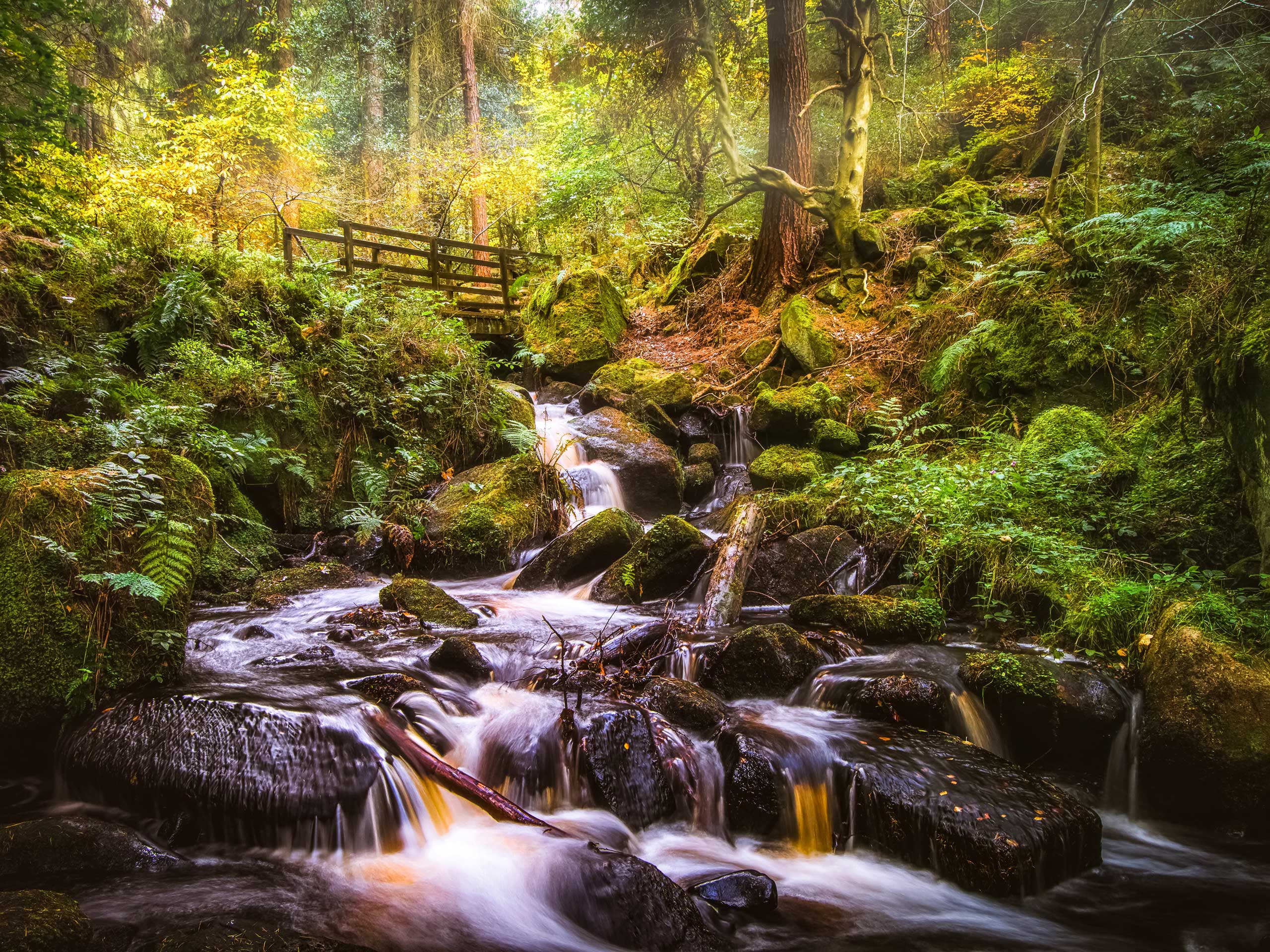
Wyming Brook
The Wyming Brook is a short river near Sheffield that is sourced from the Redmires Reservoir and flows down some fairly steep terrain towards the Rivelin Reservoir. Historically, the area surrounding the brook was a part of the Rivelin Chase hunting and hawking grounds that were utilized by the nobility. In modern times, the area is part of a nature reserve where the public can explore the natural beauty of the serene woodland landscape and spot several species of local birds.
Other amazing walks in Peak District National Park
Check out our guides to Kinder Scout, Mam Tor, Stanage Edge, Dovedale, and Padley Gorge. Or see all of our Peak District walks on 10Adventures.
Insider Hints
This route is popular during peak hours, so make sure to arrive early to secure parking.
Parts of this trail can be quite rocky and steep, take care when travelling with children and wear proper walking boots.
The trail is dog-friendly, so make sure to bring your canine companions for a full family adventure.
Similar hikes to the Wyming Brook and Rivelin Reservoir Walk hike

Valehouse Reservoir Circular
The Valehouse Reservoir Circular is a 3.1mi lollipop trail near Glossop that travels around the edge of the…

Edale Rocky Ridges Walk
The Edale Rocky Ridges Walk is just that - an adventurous walk along a rugged ridgeline. While out on the…
Ladybower Reservoir & Derwent Edge Walk
The Ladybower Reservoir & Derwent Edge Walk is a fantastic route that offers gorgeous views across the Peak District Landscape.…
Comments