
Dunford Bridge to Penistone Walk
View Photos
Dunford Bridge to Penistone Walk
Difficulty Rating:
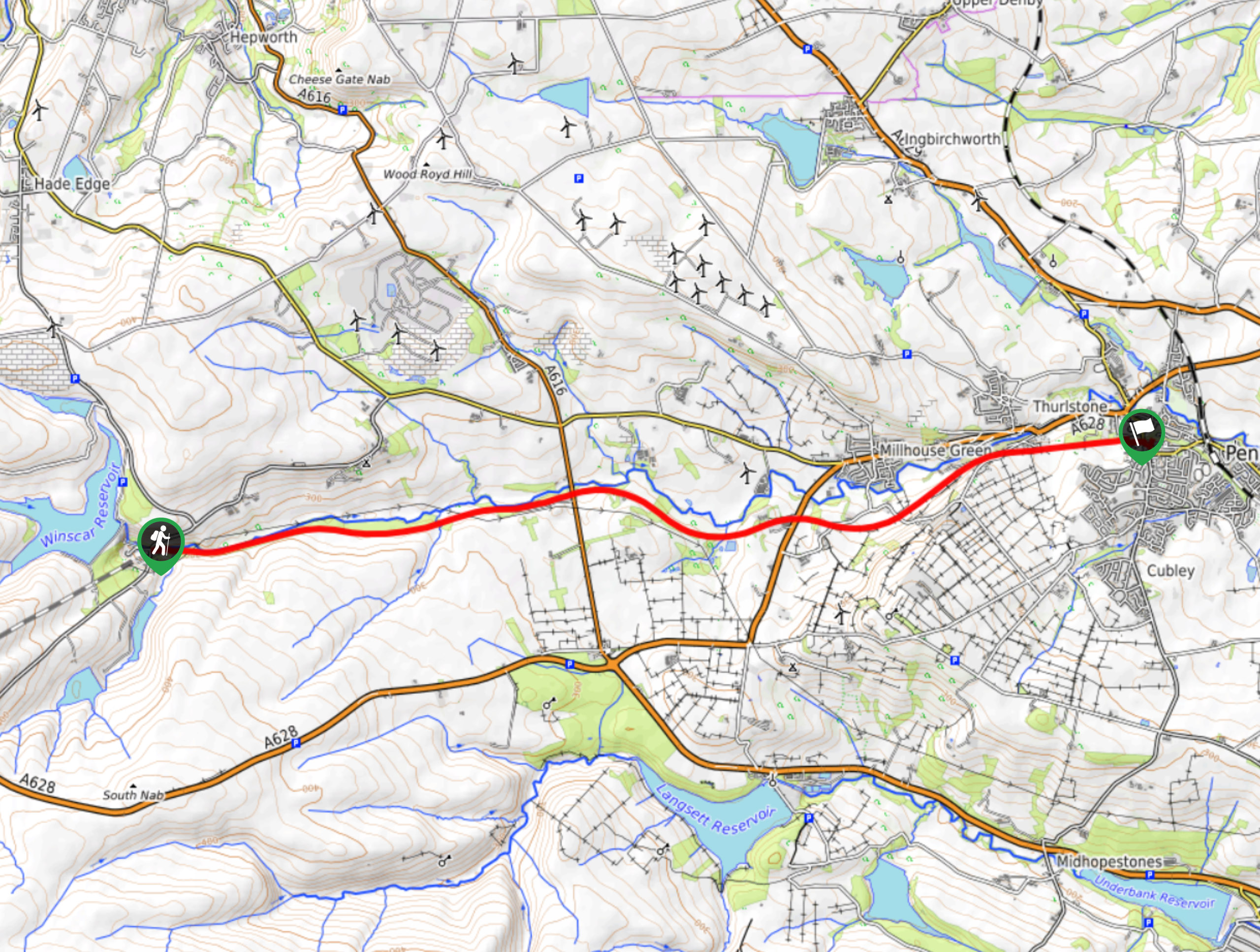
The walk from Dunford Bridge to Penistone is a charming stroll along some fairly flat terrain that connects the village to the larger town. The trail runs parallel to the River Don and offers some scenic views of the surrounding landscape as you cut through the countryside towards the east. Although you can walk this route, it is largely used by cyclists, so make sure to keep an eye out and leave enough room for people to pass.
Getting there
To reach the car park for the Dunford Bridge to Penistone Walk from Penistone, head west on Thurlstone Road for 1.6mi and turn right onto Lee Lane. After 2.6mi, turn left onto Brook Hill Lane and follow it for 1.5mi. Continue onto Windle Edge and after 0.3mi, you will find the car park on the left.

About
| When to do | Year-Round |
| Backcountry Campsites | No |
| Pets allowed | Yes - On Leash |
| Family friendly | Yes |
| Route Signage | Average |
| Crowd Levels | Moderate |
| Route Type | One Way |
Dunford Bridge to Penistone Walk
Elevation Graph
Weather
Dunford Bridge to Penistone Trail Description
Walking from Dunford Bridge to Penistone isn’t an overly challenging task, as the terrain is fairly flat and follows along a dedicated track; however, the route is largely utilized by cyclists, so make sure to keep an eye out while walking the trail and keep to the side to allow any passers by enough room to safely do so. Additionally, this is a one-way walk between the two points, so be sure to make arrangements for a pick up in Penistone or you will have to double back along the trail for an 18km round trip.
This route is a scenic stroll through the countryside that will expose you to some amazing views of the farms, villages, and woodlands that make up the terrain along the edge of the Peak District. Along the trail, you will follow closely along the winding banks of the River Don as it weaves between villages to eventually arrive at the town of Penistone. This walk is perfect for a leisurely weekend stroll, as long as you arrive early enough to snag a parking spot!
Setting out from the car park, head east along the trail and pass by the picnic area, keeping right at the fork to avoid walking along the private track that goes down to the edge of the River Don. Keep straight along the tree-lined path for the next 1.8mi, enjoying the intermittent views of the countryside until you pass under a bridge. From here, continue on for 0.5mi to pass by the Pennine Cottage on your right and arrive at the old railway station at the edge of the A616.
Cross over the road and continue along the trail, keeping straight for the next 1.3mi. Along this stretch of the walk, you will pass under three bridges and arrive at a crossing over Manchester Road. Make your way over the bridge and continue on to the east along the final leg of the walk.
As you walk along the forested trail, you will begin to feel the influence of the city increase, as the open fields of the countryside are at first interrupted by a series of small cottages, only to be replaced by more densely packed urban areas. After 1.9mi of walking from the last bridge crossing, you will arrive at the end of the trail in the heart of Penistone. From here, you can find a place for a quick drink and bite to eat in town, or make your way back to the car park in Dunford Bridge via your desired method of transportation.
Other amazing walks in Peak District National Park
Check out our guides to Kinder Scout, Mam Tor, Stanage Edge, Dovedale, and Padley Gorge. Or see all of our Peak District walks on 10Adventures.
Insider Hints
This trail is largely used by cyclists, so keep an eye out and leave plenty of room to pass.
Similar hikes to the Dunford Bridge to Penistone Walk hike

Valehouse Reservoir Circular
The Valehouse Reservoir Circular is a 3.1mi lollipop trail near Glossop that travels around the edge of the…

Three Edges Walk
The Three Edges Walk is a challenging circuit in Derbyshire that will take you along three escarpments that offer some…

Edale Rocky Ridges Walk
The Edale Rocky Ridges Walk is just that - an adventurous walk along a rugged ridgeline. While out on the…
Comments