
Digley Reservoir & Moors Circular Walk
View Photos
Digley Reservoir & Moors Circular Walk
Difficulty Rating:
The Digley Reservoir & Moors Circular Walk is an 5.3mi circuit on the edge of the Peak District that will take you to an elevated position on the moor for some nice views of the surrounding area. Terrain along this route is fairly easy-going, with only a few steep sections of trail and some pleasant walking paths along the edge of the water. This is a nice intermediate length route for a leisurely weekend stroll across the rugged terrain of the moor.
Getting there
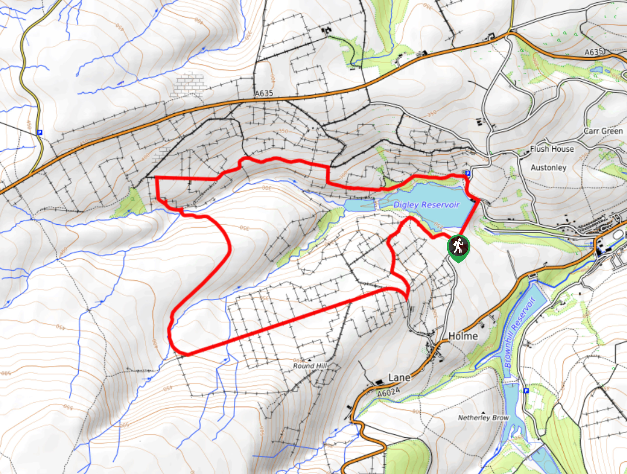
To reach the car park for the Digley Reservoir & Moors Circular from Holmfirth, drive southwest on Huddersfield Road for 1.7mi and turn right onto Field End Lane. After 0.3mi, continue onto Bank Top Lane and follow it for another 0.3mi. Turn left onto Fieldhead Lane and you will find the car park on the right in 0.2mi.

About
| When to do | March-November |
| Backcountry Campsites | No |
| Pets allowed | Yes - On Leash |
| Family friendly | Older Children only |
| Route Signage | Average |
| Crowd Levels | Moderate |
| Route Type | Circuit |
Digley Reservoir & Moors Circular Walk
Elevation Graph
Weather
Digley Reservoir & Moors Circular Trail Description
Walking the Digley Reservoir & Moors Circular Walk is a popular adventure for both seasoned and casual walkers alike due to the relatively easy terrain, intermediate length of the route, and scenic views of the surrounding Peak District landscape. Setting out from the car park, head northeast to walk alongside the dam wall before turning west to traverse a wonderful stretch of woodland terrain along the water’s edge. Enjoy the intermittent views across the reservoir before climbing slightly uphill to the west alongside Marsden Clough. Turn south and cross over the stream, traversing the rugged terrain of the moor while absorbing the beautiful views of the surrounding moor and farmland. Once you have met up with Issues Road, follow it east to descend through the open farmland to return to the car park where you began.
Other amazing walks in Peak District National Park
Check out our guides to Kinder Scout, Mam Tor, Stanage Edge, Dovedale, and Padley Gorge. Or see all of our Peak District walks on 10Adventures.
Similar hikes to the Digley Reservoir & Moors Circular Walk hike

Valehouse Reservoir Circular
The Valehouse Reservoir Circular is a 3.1mi lollipop trail near Glossop that travels around the edge of the…

Three Edges Walk
The Three Edges Walk is a challenging circuit in Derbyshire that will take you along three escarpments that offer some…

Edale Rocky Ridges Walk
The Edale Rocky Ridges Walk is just that - an adventurous walk along a rugged ridgeline. While out on the…
Comments