
Mount Fromme Trail
View Photos
Mount Fromme Trail
Difficulty Rating:
The Mount Fromme Trail is a great out-and-back option for when you are looking to spend half a day and reconnect with nature. Better known for its mountain bike trails, Mount Fromme is less popular with hikers, which is excellent if you are looking for a bit of solitude. With beautiful views from the summit, this is a less-travelled option that should be on everyone’s list.
Getting there
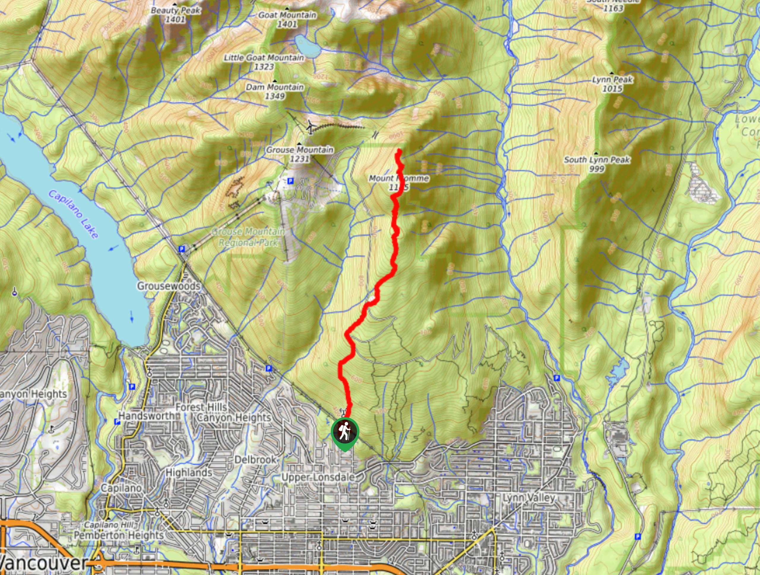
To get to the Mount Fromme trailhead from Vancouver, head west along the Trans Canada Highway/BC-1, taking exit 18 for Lonsdale Avenue. Follow Lonsdale Avenue North for 0.7mi and turn right onto Braemar Road. In 820ft, turn right onto St. Georges Avenue and the trailhead will be at the end of the cul-de-sac.

About
| When to do | July-November |
| Backcountry Campsites | No |
| Pets allowed | Yes - On Leash |
| Family friendly | No |
| Route Signage | Average |
| Crowd Levels | Moderate |
| Route Type | Out and back |
Mount Fromme Trail
Elevation Graph
Weather
Mount Fromme Trail Description
This 6.4mi hike on Vancouver’s North Shore is less well-travelled than many other routes in the surrounding area, possibly due to the partially obstructed views and high level of tree cover along the trail. Mount Fromme is known more for its mountain bike trails than its hiking routes, so mind the trail markers as these two types of trails intersect along the route, making it difficult to navigate if you are not paying attention.
The Mount Fromme trail is a great half-day option if you are just looking to get out into the wilderness along a less populated trail. The gradual climb and near-constant tree cover make this a pleasant hike, where you won’t be baking in the sun or traversing any particularly difficult sections of terrain. As mentioned, the views from Mount Fromme are partially obstructed, and while there are more scenic hikes along the North Shore, you will still be rewarded with views of nearby Lynn Ridge, Coliseum Mountain, and Mount Seymour.
From the end of the cul-de-sac on Saint Georges Avenue, follow the trail as it enters the forest and crosses over a small wooden bridge. You will soon arrive at a cleared section of trees along a stretch of power lines. Turn right, walking underneath the power lines until you reach a junction in the trail leading to the left. Follow this path to the left as you set out on the St. Georges Trail.
Approximately 164ft up the trail it will transition into a narrower path leading through the trees. Follow this trail as it climbs steeply uphill, making your way to a series of quick junctions. Go left at the first junction and in a few meters you will need to turn right to continue on the St. Georges Trail.
As you gain elevation along the route, you will quickly come upon a junction with the Baden Powell Trail. Continue on the path straight ahead, crossing over the Baden Powell Trail and uphill to a technical section of trail over loose rocks and roots. The St. Georges trail will come to an end as you meet up with the Old Grouse Mountain Highway.
From here, head left on the gravel road for 492ft, where the road will turn a corner. Along the outside edge of the bend in the road there will be a trail junction that leads out in several directions. This can be tricky to navigate if you are unfamiliar with the area. Do not follow the wide trail that heads north away from the road. Instead, take the Peer Gynt trail that can be found to the right of the wooden trail sign and follow it uphill through the trees.
As you continue climbing, the trail will once again reach a junction with the Old Grouse Mountain Highway. Cross directly over to the other side and through the ditch, utilizing the handrope to pull yourself over the embankment and back onto the trail. Keep moving along the trail as it gradually makes its way toward Mount Fromme.
At this point in the route, the trail will begin to steepen, leaving behind the gradual incline that has been a constant since the beginning of the hike. You will need to pull yourself up and over some rooted trees as you continue your ascent to the peak of Mount Fromme. As the trail levels out, you will reach a junction where you will turn right, with the summit only a few hundred meters in front of you.
From your vantage point at the summit of Mount Fromme, there will not be many views of the city to the south, as the tree cover is too heavy. Instead, look to the north for some beautiful views of back-country mountains, where you will be able to see all the way out to Garibaldi Provincial Park on a clear day. To the east you will be able to spot Mount Seymour, the Lynn Ridge, and Mount Elsay off in the distance.
After spending a few moments resting up and taking in the views, head back down the tree-covered trail along the same route to return to your car having completed the Mount Fromme Trail.
Hiking Route Highlights
Mount Seymour
Named after Frederick Seymour, the second Governor of the Colony of British Columbia, this peak stands at 4754ft and is the namesake of Mount Seymour Provincial Park.
Garibaldi Provincial Park
Located 43.5mi north of Vancouver, Garibaldi Provincial Park was established in 1920 and spans an area over 1950 square kilometers. The western portion of the park is easily accessible due to its proximity to the Sea to Sky Highway, and as a result the park sees over 100,000 day users each year.
Similar hikes to the Mount Fromme Trail hike

Lynn Lake Trail
The Lynn Lake Trail is a lengthy hike through the Lynn Headwaters backcountry that is sure to get you off…

Old Buck and Bridle Trail Loop
The Old Buck and Bridle Trail Loop is an amalgamation of the Old Buck, Bridle, and Baden Powell trails that…

Goldie and Flower Lake Loop
The Goldie and Flower Lake Loop is a short trail that makes its way through the peaceful terrain surrounding these…
Comments