
Westwood Lake Trail
View Photos
Westwood Lake Trail
Difficulty Rating:
The Westwood Lake Trail is a 3.6mi hiking circuit west of Nanaimo, BC that will lead you around the edge of this stunning woodland lake for a fun, family-friendly adventure. Along the trail, you will experience a peaceful forest setting and have access to some amazing views that stretch out across the calm lake and the surrounding woodland landscape. This trail is perfect for a quick outdoor getaway to reconnect with nature without needing to leave the city.
Getting there
To reach the Westwood Lake Trail parking area from Nanaimo, head west on Fitzwilliam Street for 2625ft and continue straight onto Third Street for another 1.2mi. Keep straight onto Jingle Pot Road and follow it for 0.8mi before turning left on Westwood Road. In 0.6mi, you will find the parking area on your right.

About
| When to do | Year-Round |
| Backcountry Campsites | No |
| Pets allowed | Yes - On Leash |
| Family friendly | Yes |
| Route Signage | Average |
| Crowd Levels | High |
| Route Type | Circuit |
Westwood Lake Trail
Elevation Graph
Weather
Westwood Lake Trail Description
While the Westwood Lake Trail is a great route for almost every variety of hiker, there are a few minor elevation gains along the foot of Mount Benson that could limit travel for those who are less mobile. Additionally, this trail is connected to a number of other hiking routes in the area, and as such it is riddled with intersecting routes. While the trail is well-marked, it might still be a good idea to bring a trail map or GPS to avoid any confusion while out on the trail.
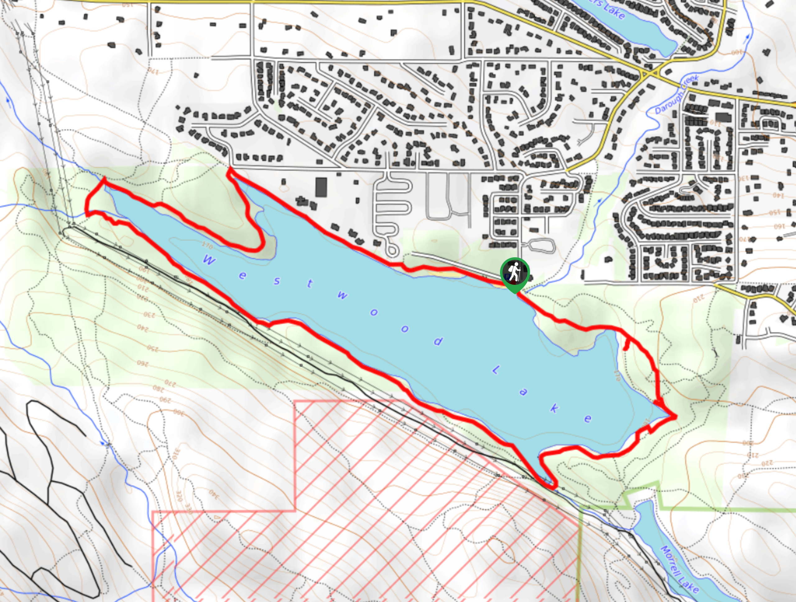
The well-kept pathways and amazingly scenic views along this trail make it a perfect option for those hikers looking for a fun adventure without leaving Nanaimo. The trail works around the heavily-wooded shores of Westwood Lake and provides hikers with a great sightline across its calm waters. For little required effort, this is an awesome route with great views that can be enjoyed by all.
Setting out from the trailhead, make your way west along the north shore of the lake with the water on your left and a residential neighbourhood on your right. After enjoying the intermittent views across the water for 0.7mi, the trail will turn to the south and begin to enter a more dense stretch of forest along the western edge of the lake. From here, follow the trail as it winds along the edge of the water and provides a nice view of the large number of fallen trees scattered across the surface of the lake.
Reaching the southwest corner of the trail loop, follow the path as it turns to the east and crosses over a creek, before following closely along the southern shore of the lake. Here, you will have a different perspective of the water, this time with the city in the backdrop. Continue east on the trail, as it bobs up and down along a series of minor climbs and falls. Roughly 1.2mi from the creek crossing, you will briefly exit the cover of the forest to work around the southeast corner of the lake before returning to the shade of the forest canopy overhead.
Enjoy the last 0.9mi of peaceful forest atmosphere, as you hike past large mature trees and gaze out across the water on the return to the trailhead where you began your hike. For those looking to spend some more time around Westwood Lake, try exploring the strong network of trails in the area or planting yourself at one of the two beaches near the parking area for a fun day in the sun.
Insider Hints
Arrive early, as the trail can become quite busy during peak times.
This is a family-friendly trail but it does have some minor elevation gains near the foot of Mount Benson.
The trail is well-marked; however, there are a number of intersecting trails that might cause some confusion. Bring a trail map or GPS to stay on the correct path.
Similar hikes to the Westwood Lake Trail hike
Crystal and McKay Lakes Loop Trail
The Crystal and McKay Lakes Loop Trail is a 4.1mi hiking circuit southwest of Nanaimo that winds through…
Living Forest River Walk
The Living Forest River Walk is a wonderfully scenic out-and-back trail in Nanaimo that will take you along the edge…
Benson Creek Falls Trail
The Benson Creek Falls trail is a 1.8mi out-and-back hiking route near Nanaimo, BC, that will lead you…
Comments